Category:Maps of Bandelier National Monument
US national monuments: Agate Fossil Beds · Aztec Ruins · Bandelier · Cabrillo · Canyon de Chelly · Cedar Breaks · Colorado · Craters of the Moon · Devils Postpile · Devils Tower · Dinosaur · Effigy Mounds · Florissant Fossil Beds · Gila Cliff Dwellings · Hovenweep · Jewel Cave · John Day Fossil Beds · Lava Beds · Little Bighorn Battlefield · Montezuma Castle · Muir Woods · Natural Bridges · Organ Pipe Cactus · Rainbow Bridge · Statue of Liberty · Sunset Crater Volcano · Timpanogos Cave · Walnut Canyon · Wupatki ·
English: Maps of Bandelier National Monument
Wikimedia category | |||||
| Upload media | |||||
| Instance of | |||||
|---|---|---|---|---|---|
| Category combines topics | |||||
| Bandelier National Monument | |||||
U.S. national park in New Mexico  .jpg) | |||||
| Instance of | |||||
| Named after | |||||
| Location |
| ||||
| Visitor center | |||||
| Operator | |||||
| Heritage designation |
| ||||
| IUCN protected areas category | |||||
| Inception |
| ||||
| Area |
| ||||
| Elevation above sea level |
| ||||
| Visitors per year |
| ||||
| official website | |||||
 | |||||
Media in category "Maps of Bandelier National Monument"
The following 15 files are in this category, out of 15 total.
-
 Bandelier National Monument, New Mexico LOC 99440674.jpg 5,003 × 6,942; 4.7 MB
-
 Bandelier National Monument, New Mexico LOC 99440674.tif 5,003 × 6,942; 99.37 MB
-
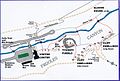
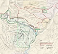
 NPS bandelier-detail-map.jpg 694 × 1,807; 234 KB
-
 NPS bandelier-detail-map.pdf 654 × 1,704; 1.46 MB
-
 NPS bandelier-geologic-map.jpg 4,582 × 2,767; 4.58 MB
-
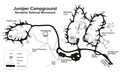
 NPS bandelier-juniper-campground-map.jpg 1,960 × 1,190; 223 KB
-
 NPS bandelier-juniper-campground-map.pdf 2,100 × 1,275; 78 KB
-
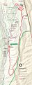
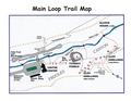
 NPS bandelier-main-loop-trail-map.jpg 1,353 × 918; 240 KB
-
 NPS bandelier-main-loop-trail-map.pdf 1,650 × 1,275; 1.32 MB
-
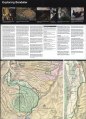
 NPS bandelier-map.jpg 1,705 × 1,588; 474 KB
-
 NPS bandelier-map.pdf 1,827 × 1,702; 3.03 MB
-
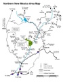
 NPS bandelier-regional-map.jpg 1,190 × 1,540; 209 KB
-
 NPS bandelier-regional-map.pdf 1,275 × 1,650, 2 pages; 305 KB
-
 NPS bandelier-trail-map.gif 1,105 × 1,430; 101 KB
-
 NPS bandelier-vegetation-map.jpg 5,148 × 3,546; 4.18 MB


