Category:Maps of Iași County
Counties of Romania: Alba · Arad · Argeș · Bacău · Bihor · Bistrița-Năsăud · Botoșani · Brașov · Brăila · Buzău · Caraș-Severin · Cluj · Constanța · Covasna · Călărași · Dolj · Dâmbovița · Galați · Giurgiu · Gorj · Harghita · Hunedoara · Ialomița · Iași · Ilfov · Maramureș · Mehedinți · Mureș · Neamț · Olt · Prahova · Sălaj · Satu Mare · Sibiu · Suceava · Teleorman · Timiș · Tulcea · Vâlcea · Vaslui · Vrancea – Capital city: Bucharest
Wikimedia category | |||||
| Upload media | |||||
| Instance of | |||||
|---|---|---|---|---|---|
| Category combines topics | |||||
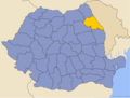
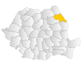
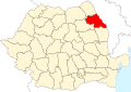
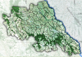
| Iași County | |||||
county of Romania    | |||||
| Instance of |
| ||||
| Location | |||||
| Capital | |||||
| Legislative body |
| ||||
| Population |
| ||||
| Area |
| ||||
| official website | |||||
 | |||||
Subcategories
This category has the following 6 subcategories, out of 6 total.
H
- Maps of Hârlău (3 F)
I
- Maps of Iași (12 F)
P
- Maps of Pașcani (3 F)
- Maps of Podu Iloaiei (3 F)
T
- Maps of Târgu Frumos (4 F)
Media in category "Maps of Iași County"
The following 15 files are in this category, out of 15 total.
-
 Iasi.png 283 × 214; 9 KB
-
 Iasi.svg 1,300 × 1,000; 290 KB
-
 Iasi County.svg 1,958 × 1,380; 1.05 MB
-
 Iasi in Romania.svg 1,611 × 1,152; 815 KB
-
 Judetul Iasi 3D map.jpg 1,062 × 764; 534 KB
-
 Provinz Iasi Romania CIA2006.png 500 × 500; 639 KB
-
 Harta jud Iasi.png 990 × 694; 43 KB
-
 Romania Iasi Location map.jpg 988 × 696; 107 KB
-
 Harta de localizare Romania Iasi.svg 1,048 × 726; 1.9 MB
-
 Harta primari iasi 2020.png 1,500 × 958; 571 KB
-
 Iași Local 2024 M.svg 995 × 675; 142 KB
-
 Judetul Iasi (1).jpg 1,106 × 766; 237 KB
-
 Judetul Iasi (2).jpg 1,106 × 766; 133 KB
-
 Romania Iasi Location maps.GIF 600 × 416; 989 KB
-
 UAT - Judetul Iasi.jpg 1,106 × 766; 184 KB


.jpg)
.jpg)

