Category:Maps of Sibiu County
Counties of Romania: Alba · Arad · Argeș · Bacău · Bihor · Bistrița-Năsăud · Botoșani · Brașov · Brăila · Buzău · Caraș-Severin · Cluj · Constanța · Covasna · Călărași · Dolj · Dâmbovița · Galați · Giurgiu · Gorj · Harghita · Hunedoara · Ialomița · Iași · Ilfov · Maramureș · Mehedinți · Mureș · Neamț · Olt · Prahova · Sălaj · Satu Mare · Sibiu · Suceava · Teleorman · Timiș · Tulcea · Vâlcea · Vaslui · Vrancea – Capital city: Bucharest
Wikimedia category | |||||
| Upload media | |||||
| Instance of | |||||
|---|---|---|---|---|---|
| Category combines topics | |||||
| Sibiu County | |||||
county of Romania    | |||||
| Instance of |
| ||||
| Location | Romania | ||||
| Capital | |||||
| Legislative body |
| ||||
| Inception |
| ||||
| Population |
| ||||
| Area |
| ||||
| official website | |||||
 | |||||
Subcategories
This category has the following 13 subcategories, out of 13 total.
A
- Maps of Agnita (4 F)
- Maps of Avrig (6 F)
C
- Maps of Cisnădie (4 F)
- Maps of Copșa Mică (5 F)
D
- Maps of Dumbrăveni (7 F)
M
- Maps of Mediaș (8 F)
- Maps of Miercurea Sibiului (4 F)
O
- Maps of Ocna Sibiului (5 F)
R
- Maps of Rășinari, Sibiu (3 F)
S
- Maps of Săliște (4 F)
- Maps of Sibiu (18 F)
T
- Maps of Tălmaciu (9 F)
Media in category "Maps of Sibiu County"
The following 28 files are in this category, out of 28 total.
-
 Sibiu.png 283 × 214; 9 KB
-
 Sibiu.svg 1,300 × 1,000; 290 KB
-
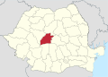
 Sibiu County.svg 1,958 × 1,380; 1.05 MB
-
 Sibiu in Romania.svg 1,611 × 1,152; 815 KB
-
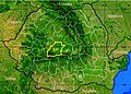 Judetul Sibiu 3D map.jpg 1,062 × 764; 184 KB
-
 Provinz Sibiu Romania CIA2006.png 400 × 400; 399 KB
-
 Sibiu-district-base.png 800 × 704; 25 KB
-
 Harta jud Sibiu.png 1,000 × 833; 26 KB
-
 Jud Sibiu.png 1,000 × 833; 29 KB
-
 Romania Sibiu Location map.jpg 813 × 705; 74 KB
-
 Romania Sibiu Location map.svg 838 × 722; 5.03 MB
-
 Harta de localizare judetul Sibiu, Romania.svg 1,534 × 1,294; 6.97 MB
-
 Prezentare Judetul Sibiu.gif 783 × 675; 2.78 MB
-
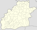
 SB County Blank Map.png 290 × 270; 26 KB
-
 Sibiu (Judeţ) BV043905167.jpg 14,406 × 11,102; 28.63 MB
-
 Harta jud Sibiu.svg 1,175 × 958; 1.14 MB
-
 Harta Tilisca.JPG 3,088 × 2,304; 364 KB
-
 HartaIstoricăRacovița.jpg 1,459 × 958; 723 KB
-
 HartaIstoricăRacovița.svg 3,520 × 2,833; 3.52 MB
-
 Prelucrare 3D pentru Colun, Sibiu.jpg 1,024 × 768; 394 KB
-
 Prelucrare 3D pentru Noul Roman, Sibiu.jpg 1,024 × 768; 405 KB
-
 Prelucrare 3D pentru Sacel, Sibiu.jpg 1,024 × 768; 336 KB
-
 Racoviţa harta toponimică.jpg 4,661 × 3,746; 2.86 MB
-
 RacovițaHartăToponimică.svg 3,180 × 2,590; 8.2 MB
-
 Sibiu 2008 alegeri locale.svg 880 × 780; 1.06 MB
-
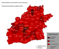 Sibiu County administrative map.png 1,534 × 1,294; 119 KB
-
 Sibiu County Hungarians.png 720 × 600; 84 KB
-
 Zona Racovita - localitati apropiate.png 543 × 244; 7 KB


_BV043905167.jpg)


