Category:Maps of Kreis Gütersloh
Wikimedia category | |||||
| Upload media | |||||
| Instance of | |||||
|---|---|---|---|---|---|
| Category combines topics | |||||
| Gütersloh | |||||
district of North Rhine-Westphalia  Gütersloh district administration building, 2008    | |||||
| Instance of |
| ||||
| Named after | |||||
| Location | Detmold Government Region, North Rhine-Westphalia, Germany | ||||
| Capital | |||||
| Head of government |
| ||||
| Inception |
| ||||
| Population |
| ||||
| Area |
| ||||
| Elevation above sea level |
| ||||
| official website | |||||
 | |||||
Subcategories
This category has the following 22 subcategories, out of 22 total.
!
- Maps of Distrikt Bielefeld (23 F)
- Maps of Distrikt Minden (2 F)
- Maps of Kreis Halle (17 F)
- Maps of Kreis Wiedenbrück (9 F)
B
- Maps of Borgholzhausen (26 F)
G
H
- Maps of Harsewinkel (18 F)
- Maps of Herzebrock-Clarholz (10 F)
L
R
- Maps of Rheda-Wiedenbrück (17 F)
- Maps of Rietberg (22 F)
S
- Maps of Schloß Holte-Stukenbrock (18 F)
- Maps of Steinhagen (Westfalen) (20 F)
V
- Maps of Verl (30 F)
- Maps of Versmold (26 F)
W
- Maps of Werther (Westfalen) (16 F)
Media in category "Maps of Kreis Gütersloh"
The following 18 files are in this category, out of 18 total.
-
 Bahnstrecke Haller-Willelm.png 1,200 × 849; 885 KB
-
 Haller Wilhelm2.png 851 × 620; 32 KB
-
 Kreis Gütersloh - nature reserves.png 1,334 × 1,304; 1.87 MB
-
 Kreis Gütersloh location map.svg 286 × 284; 15.15 MB
-
 Lage des Kreises Gütersloh in Deutschland.PNG 197 × 235; 3 KB
-
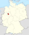 Locator map GT in Germany.svg 1,075 × 1,273; 637 KB
-
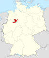
 Locator map GT in North Rhine-Westphalia.svg 657 × 656; 479 KB
-
 Locator map Minden-Ravensberg in Germany.svg 1,075 × 1,273; 947 KB
-
 North rhine w gt old colours.png 263 × 245; 39 KB
-
 North rhine w gt.png 593 × 585; 73 KB
-
 North rhine w GT.svg 660 × 660; 221 KB
-
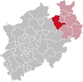 NRW RB Detmold GT.svg 592 × 584; 246 KB
-
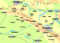
 Ravensberger-Land.png 345 × 325; 210 KB
-
 Ravensberger-Mulde.png 2,000 × 1,571; 479 KB
-
 RB Detmold 1975 beschriftet Guetersloh.svg 575 × 724; 39 KB
-
 RB Detmold 1975 Kreiseinteilung Guetersloh.png 309 × 388; 3 KB
-
 Senne-Bahn.png 1,400 × 1,685; 1.48 MB
-
 Warendorfer Bahn01.png 1,223 × 685; 237 KB


