<nowiki>Category:Maps of Lääne-Viru County; categoría de Wikimedia; kategori Wikimedia; Wikimedia category; د ويکيمېډيا وېشنيزه; Vikimedya kategorisi; ویکیمیڈیا زمرہ; kategória projektov Wikimedia; категорія проєкту Вікімедіа; 维基媒体分类; Wikimedia-Kategorie; ৱিকিমিডিয়া শ্ৰেণী; kategorie na projektech Wikimedia; Wikimedia-Kategorie; विकिपीडिया:श्रेणी; page de catégorie de Wikimedia; kategorija na Wikimediji; विकिपीडिया वर्ग; категорија на Викимедији; Wikimedia-Kategorie; Wikimedia-kategori; kategori Wikimédia; تصنيف ويكيميديا; pajenn rummata eus Wikimedia; Wikimedia:ကဏ္ဍခွဲခြင်း; 維基媒體分類; Wikimedia категориясы; categoría de Wikimedia; Wikimedia-categorie; Wikimedia-Kategorie; tudalen categori Wikimedia; kategori e Wikimedias; ردهٔ ویکیپدیا; 维基媒体分类; Wikimedia-kategory; ვიკიპედია:კატეგორიზაცია; ウィキメディアのカテゴリ; categoria Wikimedia; تصنيف بتاع ويكيميديا; විකිමීඩියා ප්රභේද පිටුව; categoria Vicimediorum; विकिमीडिया श्रेणी; Wikimedia-luokka; Wikimedia-categorie; விக்கிமீடியப் பகுப்பு; катэгорыя ў праекце Вікімэдыя; Викимедиа проектындагы төркем; catigurìa di nu pruggettu Wikimedia; หน้าหมวดหมู่วิกิมีเดีย; Wikimedia:Kategorija; Wikimedia-Kategorie; Wikimedia:Klassys; категория на Уикимедия; categorie a unui proiect Wikimedia; categurìa 'e nu pruggette Wikimedia; Wikimedia-kategori; kawan Wikimèdia; гурӯҳи Викимедиа; 위키미디어 분류; Wikimedia-bólkur; kategorio en Vikimedio; kategori Wikimedia; Wikimedia:Ronnaghys; উইকিমিডিয়া বিষয়শ্রেণী; kategori Wikimedia; 维基媒体分类; וויקימעדיע קאַטעגאָריע; kategorija w projektach Wikimedije; thể loại Wikimedia; Wikimedia projekta kategorija; Wikimedia-kategorie; categoria de um projeto da Wikimedia; Wikimedia category; категорияд Ангилал; Wikimedia-kategori; kategori Wikimedia; پۆلی ویکیمیدیا; Wikimedia category; Vikimédia ñemohenda; Wikimédia-kategória; વિકિપીડિયા શ્રેણી; Wikimediako kategoria; категория в проекте Викимедиа; Wikimedia-Kategorie; Kategoriya ning Wikimedia; Wikimedia-kategorie; Wîkîmediya:Kategorî; विकिमिडिया श्रेणी; Wikimedia-Kategorie; קטגוריה במיזמי ויקימדיה; Викимедиа проектындагы төркем; κατηγορία εγχειρημάτων Wikimedia; categoría de Wikimedia; विकिमिडिया श्रेणी; Wikimedia-kategoriija; гурӯҳи Викимедиа; Wikimedia-Kategorie; Wikimedia-categorie; Wikimedia category; categoria di un progetto Wikimedia; categoria de Wikimedia; jamii ya Wikimedia; 维基媒体分类; Wikimedia kategooria; 維基媒體分類; Vikipidiya:Shopni; Wikimedia proyektındağı törkem; катэгорыя ў праекце Вікімедыя; ẹ̀ka Wikimedia; 維基媒體分類; categoria de um projeto da Wikimedia; Викимедиина категорија; kategorija na Wikimediji; tumbung Wikimedia; Վիքիմեդիայի նախագծի կատեգորիա; kategorija Wikimedie; kategorya ng Wikimedia; kategoria ti Wikimedia; Viciméid catagóir; kategori Wikimedia; kategoria w projekcie Wikimedia; വിക്കിമീഡിയ വർഗ്ഗം; 維基媒體分類; kategori Wikimedia; Wikimedia-kategori; زمرو:وڪيپيڊيا زمرا بندي; Викимедиа категорияһы; categoría de Wikimedia; 維基媒體分類; 维基媒体分类; guruhi Vikimedia</nowiki>
Subcategories
This category has the following 3 subcategories, out of 3 total.


 EE Lääne-Viru outline.svg 656 × 942; 4.16 MB
 Estonia Lääne-Viru locator map.svg 1,668 × 1,393; 629 KB
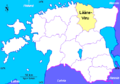 Estonia map Lanne Viru.PNG 500 × 350; 13 KB
 Karepa.gif 2,947 × 1,446; 371 KB
 Laane-Viru municipalities.png 1,056 × 816; 38 KB
 Laane-Virumaa vallad.png 673 × 870; 110 KB
 Lääne-Viru County in Estonia.svg 1,666 × 1,391; 422 KB
 Lääne-Viru in Estonia.svg 1,668 × 1,393; 751 KB
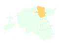 Lääne-Viru maakond.svg 884 × 636; 450 KB
 Lääne-Viru municipalities 2017.png 810 × 894; 64 KB
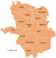 Lääne-Virumaa vallad.svg 403 × 416; 533 KB
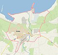 Map of Kunda 2020-10-05.jpg 1,212 × 1,154; 554 KB
 Taps Liefland 1774.jpg 3,959 × 2,210; 1.21 MB
 USSR map NO 35-2 Rakvere.jpg 4,941 × 4,362; 5.14 MB
 Vironiae Occidentalis municipia.PNG 640 × 495; 99 KB
 Вырезка из карты Люфтваффе Taps 1941.jpg 229 × 262; 44 KB
 Деловой-топплан 2011.jpg 4,370 × 6,157; 5.95 MB
 Деревня Тапс на карте Лифляндии и Эстляндии 1801.jpg 937 × 956; 236 KB


