Category:Maps of Wayne County, Pennsylvania
Counties of Pennsylvania : Adams · Allegheny · Armstrong · Beaver · Bedford · Berks · Blair · Bradford · Bucks · Butler · Cambria · Cameron · Carbon · Centre · Chester · Clarion · Clearfield · Clinton · Columbia · Crawford · Cumberland · Dauphin · Delaware · Elk · Erie · Fayette · Forest · Franklin · Fulton · Greene · Huntingdon · Indiana · Jefferson · Juniata · Lackawanna · Lancaster · Lawrence · Lebanon · Lehigh · Luzerne · Lycoming · McKean · Mercer · Mifflin · Monroe · Montgomery · Montour · Northampton · Northumberland · Perry · Philadelphia · Pike · Potter · Schuylkill · Snyder · Somerset · Sullivan · Susquehanna · Tioga · Union · Venango · Warren · Washington · Wayne · Westmoreland · Wyoming · York
Wikimedia category | |||||
| Upload media | |||||
| Instance of | |||||
|---|---|---|---|---|---|
| Category combines topics | |||||
| Wayne County | |||||
county in Pennsylvania, United States   | |||||
| Instance of | |||||
| Named after | |||||
| Location | Pennsylvania | ||||
| Capital | |||||
| Inception |
| ||||
| Population |
| ||||
| Area |
| ||||
| Different from | |||||
| official website | |||||
 | |||||
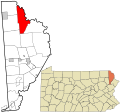
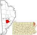
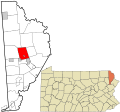
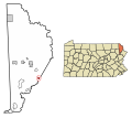
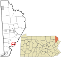
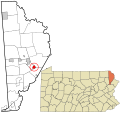
Wayne County is located in northeastern Pennsylvania in the United States. Its county seat is Honesdale.
Subcategories
This category has only the following subcategory.
.
Media in category "Maps of Wayne County, Pennsylvania"
The following 48 files are in this category, out of 48 total.
-
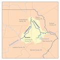 Lackariversmap.png 500 × 500; 107 KB
-
 Lehighrivermap.png 300 × 300; 22 KB
-
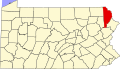 Map of Pennsylvania highlighting Wayne County.svg 4,950 × 2,846; 106 KB
-
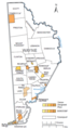
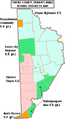 Map of Wayne County Pennsylvania School Districts.png 284 × 520; 12 KB
-

-
 Map of Wayne County, Pennsylvania No Text.png 1,112 × 2,420; 62 KB
-
 Map of Wayne County, Pennsylvania.png 1,112 × 2,420; 119 KB
-

-

-

-
-

-
-

-

-

-
-

-

-
-

-

-

-

-

-

-

-

-

-

-

-

-

-

-

-

-

-

-

-

-

-

-
-

-

-
-
 Wayne County Pennsylvania incorporated and unincorporated areas.svg 835 × 781; 4.14 MB
-
 Wayne County, Pennsylvania, Municipalities and CDPs.png 345 × 639; 76 KB


