Category:Maps of census statistical areas in Arizona
States of the United States: Alabama · Alaska · Arizona · Arkansas · California · Colorado · Connecticut · Delaware · Florida · Georgia · Idaho · Illinois · Indiana · Iowa · Kansas · Kentucky · Louisiana · Maine · Maryland · Massachusetts · Michigan · Minnesota · Mississippi · Missouri · Montana · Nebraska · Nevada · New Hampshire · New Jersey · New Mexico · New York · North Carolina · North Dakota · Ohio · Oklahoma · Oregon · Pennsylvania · Rhode Island · South Carolina · South Dakota · Tennessee · Texas · Utah · Vermont · Virginia · Washington · West Virginia · Wisconsin
Puerto Rico
Puerto Rico
Media in category "Maps of census statistical areas in Arizona"
The following 6 files are in this category, out of 6 total.
-
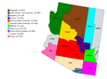 Arizona CBSAs.png 4,932 × 3,651; 553 KB
-
 Heber Map.png 881 × 511; 156 KB
-
 HeberMap.png 882 × 600; 196 KB
-
 HeberOvergaardMap.png 882 × 554; 204 KB
-
 Phoenixmetro.png 300 × 300; 35 KB
-
 Safford Micropolitan Area.png 300 × 350; 11 KB


