Category:Maps of census statistical areas in Maryland
States of the United States: Alabama · Alaska · Arizona · Arkansas · California · Colorado · Connecticut · Delaware · Florida · Georgia · Idaho · Illinois · Indiana · Iowa · Kansas · Kentucky · Louisiana · Maine · Maryland · Massachusetts · Michigan · Minnesota · Mississippi · Missouri · Montana · Nebraska · Nevada · New Hampshire · New Jersey · New Mexico · New York · North Carolina · North Dakota · Ohio · Oklahoma · Oregon · Pennsylvania · Rhode Island · South Carolina · South Dakota · Tennessee · Texas · Utah · Vermont · Virginia · Washington · West Virginia · Wisconsin
Puerto Rico
Puerto Rico
Media in category "Maps of census statistical areas in Maryland"
The following 12 files are in this category, out of 12 total.
-
 Baltimore-Towson Metropolitan Area.png 566 × 311; 22 KB
-
 Baltimore-Washington-NOVA Metropolitan Area.png 403 × 301; 36 KB
-
 Dc msa map.png 500 × 500; 244 KB
-
 Dc-balt-metro.jpg 674 × 444; 43 KB
-
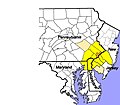 DelawareValley.jpg 924 × 805; 158 KB
-
 Delawarevalleymap.png 300 × 300; 29 KB
-
 Map of the USA highlighting the Baltimore Metropolitan Area.gif 4,200 × 3,105; 1.78 MB
-
 Map of Washington-Baltimore-Arlington CSA, 2012.jpg 2,256 × 2,943; 3.1 MB
-
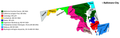 Maryland CBSAs 2020.png 6,396 × 2,044; 709 KB
-
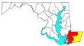
 Salisbury MSA.png 591 × 297; 6 KB
-
 Salisbury-Ocean Pines CSA.png 566 × 311; 22 KB
-
 Washington-Baltimore-Northern Virginia CSA, 2005.png 953 × 713; 130 KB


