Category:Maps showing 1944
| ← 1940 1941 1942 1943 1944 1945 1946 1947 1948 1949→ |
English: Maps showing the year 1944 (i.e. history maps)
See also category: 1944 maps. and 1940s maps for more maps showing this year usually created not long after the given year.
See also category: 1944 maps. and 1940s maps for more maps showing this year usually created not long after the given year.
Subcategories
This category has the following 3 subcategories, out of 3 total.
M
N
- NavWarMaps (8 F)
Media in category "Maps showing 1944"
The following 20 files are in this category, out of 20 total.
-
 Comprehensive Cartographia - South America 1944.png 1,579 × 2,160; 156 KB
-
Evolution of United States standard time zone boundaries.webm 29 s, 3,507 × 2,480; 4.58 MB
-
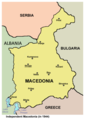
 Independent Macedonia 1944 EN.png 908 × 1,313; 30 KB
-
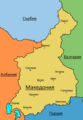
 Macedonia 1944 bg.png 320 × 449; 48 KB
-
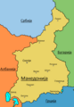
 Macedonia 1944 en2.png 320 × 449; 55 KB
-
 The settlement of the northern part of the Aukh district by Laks in 1944.svg 744 × 1,064; 477 KB
-
 World War II 1944 01.png 1,357 × 628; 33 KB
-
 World War II 1944 02.png 1,357 × 628; 34 KB
-
 World War II 1944 03.png 1,357 × 628; 33 KB
-
 World War II 1944 04.png 1,357 × 628; 34 KB
-
 World War II 1944 05.png 1,357 × 628; 33 KB
-
 World War II 1944 06.png 1,357 × 628; 33 KB
-
 World War II 1944 07.png 1,357 × 628; 33 KB
-
 World War II 1944 08.png 1,357 × 628; 33 KB
-
 World War II 1944 09.png 1,357 × 628; 34 KB
-
 World War II 1944 10.png 1,357 × 628; 33 KB
-
 World War II 1944 11.png 1,357 × 628; 33 KB
-
 World War II 1944 12.png 1,357 × 628; 33 KB
-
 Независима Държава Македония 1944.png 908 × 1,313; 29 KB
-
 Независна Држава Македониjа 1944.png 908 × 1,313; 29 KB


