Category:SVG maps of the history of Belgium
Media in category "SVG maps of the history of Belgium"
The following 43 files are in this category, out of 43 total.
-
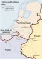 Partition-plan-Talleyrand-en.svg 426 × 599; 312 KB
-
 1815-VerenigdKoninkrijkNederlanden-en.svg 791 × 1,112; 209 KB
-
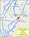 Covering of the Senne EN v1.2.svg 1,416 × 1,750; 107 KB
-
 Voutement de la Senne FR.svg 1,416 × 1,750; 106 KB
-
 Belgien 1914 - Eroberung von Lüttich.svg 664 × 581; 13 KB
-
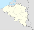 Belgium location map 1839-1919.svg 1,136 × 988; 427 KB
-
 Departments of French Empire Nethes 1811.svg 957 × 838; 960 KB
-
 Departments of French Empire North 1811-de.svg 525 × 775; 52 KB
-
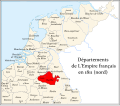
 Departments of French Empire North 1811-fr.svg 525 × 775; 144 KB
-
 District of Brussels.svg 450 × 456; 509 KB
-
 France Flanders language-de.svg 504 × 346; 119 KB
-
 Generaal gouvernementen 1814 Lage Landen-es.svg 646 × 818; 600 KB
-
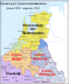 Generaal gouvernementen 1814 Lage Landen.svg 683 × 838; 794 KB
-
 Generaal gouvernementen 1815 Lage Landen.svg 683 × 838; 714 KB
-
 German occupation of Belgium 1914-1916-es.svg 831 × 727; 571 KB
-
 Departments of French Empire Jemmapes 1811.svg 957 × 838; 960 KB
-
 LandenVanOvermaas.svg 712 × 770; 904 KB
-
 Limburg grenswijzigingen 20ste eeuw.svg 512 × 438; 402 KB
-
 Limburggrenzen.svg 1,301 × 1,721; 61 KB
-
 LimburgTeilung1839 mk.svg 524 × 765; 80 KB
-
 LimburgTeilung1839.svg 524 × 765; 79 KB
-
 Departments of French Empire Lys 1811.svg 957 × 838; 960 KB
-
 Map Burgundian Netherlands 1477-af.svg 744 × 1,052; 125 KB
-
 Map Burgundian Netherlands 1477-es.svg 737 × 850; 345 KB
-
 Map Burgundian Netherlands 1477-fr.svg 748 × 858; 126 KB
-
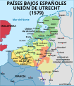 Map Union of Arras and Utrecht 1579-es.svg 750 × 860; 132 KB
-
 Map Union of Arras and Utrecht 1579-fr.svg 750 × 860; 132 KB
-
 Map Union of Arras and Utrecht 1579-gl.svg 750 × 860; 173 KB
-
 Military Administration in Belgium and Northern France (1942).svg 450 × 456; 500 KB
-
 Departments of French Empire Ourthe 1811.svg 957 × 838; 960 KB
-
 OvermaasPartage 1661 hu.svg 678 × 826; 1.46 MB
-
 OvermaasPartage1661 de.svg 678 × 826; 1.46 MB
-
 OvermaasPartage1661.svg 678 × 826; 1.47 MB
-
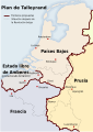 Partition-plan-Flahaut-es.svg 426 × 599; 225 KB
-
 Partition-plan-Flahaut-nl.svg 426 × 599; 312 KB
-
 Partition-plan-Talleyrand-de.svg 426 × 599; 471 KB
-
 Partition-plan-Talleyrand-nl.svg 426 × 599; 312 KB
-
 PaísesBajosAustriacos1786.svg 2,623 × 2,233; 621 KB
-
 Proposed Wallonia in 1905.svg 1,650 × 1,344; 226 KB
-
 Reichsgau Flandern.svg 450 × 456; 509 KB
-
 Reichsgau Wallonien.svg 450 × 456; 509 KB
-
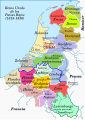 Reino Unido de los Países Bajos en 1815-es.svg 791 × 1,112; 527 KB
-
 Departments of French Empire SambreMeuse 1811.svg 957 × 838; 960 KB


.svg)


