Category:SVG maps of the history of Estonia

Media in category "SVG maps of the history of Estonia"
The following 21 files are in this category, out of 21 total.
-
 Teutonic Order 1466-es.svg 1,210 × 1,053; 1.79 MB
-
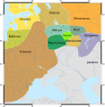
 Ancient Estonian counties.svg 1,281 × 878; 221 KB
-
 Baltic states territorial changes 1939-45 en.svg 1,198 × 1,302; 411 KB
-
 Baltic states territorial changes 1939-45 es.svg 1,198 × 1,302; 411 KB
-
 Confederation of Livonia 1260-fr.svg 955 × 1,034; 1.36 MB
-
 Confederazione Livone.svg 955 × 1,034; 621 KB
-
 Finno-ugrian-map-de.svg 963 × 987; 927 KB
-
 Finno-ugrian-map-es.svg 963 × 987; 1.01 MB
-
 Finno-ugrian-map-pt.svg 963 × 987; 992 KB
-
 Finno-ugrian-map-ukr.svg 963 × 987; 927 KB
-
 Finno-ugrian-map.svg 963 × 987; 927 KB
-
 Finnugroj en 1000 (eo).svg 963 × 987; 927 KB
-
 Inflanty 1260.svg 895 × 969; 984 KB
-
 Kievan-rus-1015-1113-(hu).svg 2,166 × 2,659; 608 KB
-
 Księstwo Kurlandii i Semigalii w 1740 roku 1740.svg 1,074 × 945; 482 KB
-
 Livland 1260.svg 955 × 1,034; 790 KB
-
 Medieval Livonia 1260 hu.svg 1,273 × 1,379; 1.07 MB
-
 Medieval Livonia 1260.svg 955 × 1,034; 734 KB
-
 Moonsund 1917 map.svg 2,980 × 4,213; 1.52 MB
-
 PBW June 1920-es.svg 2,014 × 1,567; 1.36 MB
-
 Reichskommissariat Ostland (1942).svg 450 × 456; 506 KB


.svg)

.svg)


.svg)