Category:St Nivet's Church, Lanivet
| Object location | | View all coordinates using: OpenStreetMap |
|---|
church in Cornwall, England, UK  | |||||
| Upload media | |||||
| Instance of | |||||
|---|---|---|---|---|---|
| Location | Lanivet, Cornwall, South West England, England | ||||
| Diocese | |||||
| Heritage designation |
| ||||
| Religion or worldview | |||||
 | |||||
Media in category "St Nivet's Church, Lanivet"
The following 24 files are in this category, out of 24 total.
-
 Cross in Lanivet Churchyard - geograph.org.uk - 56428.jpg 461 × 640; 98 KB
-
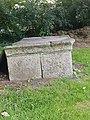 Lanivet - 18th century chest tomb.jpg 2,889 × 3,851; 3.15 MB
-
 Lanivet - Centre of Cornwall (01).jpg 1,853 × 2,964; 1.65 MB
-
 Lanivet - Centre of Cornwall (02).jpg 1,788 × 3,184; 2.02 MB
-
 Lanivet - Centre of Cornwall (03).jpg 2,734 × 2,726; 1.56 MB
-
 Lanivet - Centre of Cornwall (04).jpg 3,024 × 4,032; 3.83 MB
-
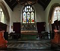
 Lanivet - Church of St Nivet (01).jpg 3,215 × 2,960; 1.89 MB
-
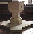
 Lanivet - Church of St Nivet (02).jpg 3,456 × 2,890; 2.18 MB
-
 Lanivet - Church of St Nivet (03).jpg 3,391 × 2,790; 2.3 MB
-
 Lanivet - Church of St Nivet (04).jpg 3,456 × 2,941; 2.18 MB
-
 Lanivet - Church of St Nivet (05).jpg 3,125 × 2,113; 2.02 MB
-
 Lanivet - Church of St Nivet (06).jpg 3,235 × 3,176; 1.74 MB
-
 Lanivet - Church of St Nivet (07).jpg 2,922 × 2,663; 1.55 MB
-
 Lanivet - Church of St Nivet (08).jpg 3,397 × 2,918; 1.36 MB
-
 Lanivet - Church of St Nivet (09).jpg 1,690 × 2,318; 610 KB
-
 Lanivet - Church of St Nivet (10).jpg 2,853 × 2,946; 1.35 MB
-
 Lanivet - Church of St Nivet (11).jpg 966 × 2,133; 505 KB
-
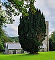 Lanivet - Irish Yew.jpg 2,382 × 2,625; 1.66 MB
-
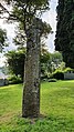
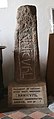
 Lanivet - Wheelhead Cross.jpg 2,150 × 2,185; 2.05 MB
-
 Lanivet Church - geograph.org.uk - 2098033.jpg 640 × 442; 84 KB
-
 Lanivet Church - geograph.org.uk - 56426.jpg 473 × 640; 101 KB
-
 Lanivet Church - geograph.org.uk - 6415006.jpg 1,024 × 718; 264 KB
-
 St Nivet's Church, Lanivet Geograph-4177122-by-Rob-Purvis.jpg 640 × 480; 164 KB
-
 The Victoria history of the county of Cornwall (1906) (14775397294).jpg 1,600 × 2,150; 303 KB


.jpg)
.jpg)
.jpg)
.jpg)
.jpg)
.jpg)
.jpg)
.jpg)
.jpg)
.jpg)
.jpg)
.jpg)
.jpg)
.jpg)
.jpg)


_(14775397294).jpg)