Category:United Kingdom photographs taken on 2004-10-21
Countries of Europe: Belgium · Estonia · Germany · Hungary · Italy · Netherlands‡ · Romania · Russia‡ · Ukraine · United Kingdom
‡: partly located in Europe
‡: partly located in Europe
| ← | 21 October 2004 | → | ||
| ← | October 2004 | → | ||

United Kingdom photographs taken on 21 October 2004.
Image files should be categorized here automatically using {{taken on}} template. Direct categorisation is also possible, if automatic is impossible.
Media in category "United Kingdom photographs taken on 2004-10-21"
The following 25 files are in this category, out of 25 total.
-

-
 Bridgemere Memorial, nr Nantwich.jpg 640 × 480; 240 KB
-
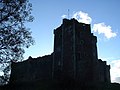 Doune Castle - geograph.org.uk - 194857.jpg 640 × 480; 79 KB
-
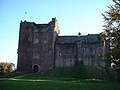 Doune Castle - geograph.org.uk - 194859.jpg 640 × 480; 79 KB
-

-

-
 Muggleswick All Saints Church - geograph.org.uk - 107479.jpg 640 × 480; 145 KB
-
 Muggleswick All Saints Church - geograph.org.uk - 107480.jpg 640 × 480; 137 KB
-
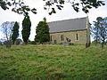
 Nether Lochaber Parish Church - geograph.org.uk - 36469.jpg 276 × 206; 50 KB
-
 RCAF Memorial 437 (T) Husky Squadron - geograph.org.uk - 92685.jpg 640 × 480; 173 KB
-
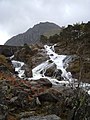 Rhaeadr Ogwen with Tryfan beyond - geograph.org.uk - 1379664.jpg 480 × 640; 85 KB
-
 St Bartholomew 13c Chapel and Corton Farm - geograph.org.uk - 290546.jpg 640 × 480; 116 KB
-
 The Avich Falls - geograph.org.uk - 107794.jpg 640 × 480; 111 KB
-
 Underneath Ashness - geograph.org.uk - 298089.jpg 526 × 640; 127 KB
-
 Waterloo Bridge London - 2004 - panoramio.jpg 2,048 × 1,536; 1.37 MB
-
 West Sedgemoor, Somerset - geograph.org.uk - 49412.jpg 640 × 480; 358 KB
-
 Blakehill Farm - geograph.org.uk - 92896.jpg 640 × 480; 107 KB
-
 High Street, Cricklade - geograph.org.uk - 92697.jpg 640 × 480; 113 KB
-
 Northycote Farm, Bushbury - geograph.org.uk - 14978.jpg 640 × 480; 93 KB
-
 Parking at the foot of the Wrekin - geograph.org.uk - 92954.jpg 640 × 480; 155 KB
-
 Ploughing at Breakheart Bottom - geograph.org.uk - 314640.jpg 640 × 427; 60 KB
-
 Pylon near Rudry - geograph.org.uk - 74366.jpg 640 × 480; 157 KB
-
 Swell Drove, West Sedgemoor, Somerset - geograph.org.uk - 50540.jpg 640 × 418; 165 KB
-
 The Imber Range Path at Breakheart Bottom - geograph.org.uk - 314637.jpg 640 × 427; 106 KB
-
 Wrekin Farm - geograph.org.uk - 92942.jpg 640 × 480; 100 KB


_Husky_Squadron_-_geograph.org.uk_-_92685.jpg)


