Category:United Kingdom photographs taken on 2005-09-03
Countries of Europe: Austria · Belgium · Czech Republic · Denmark · France‡ · Germany · Greece · Hungary · Republic of Ireland · Italy · Latvia · Netherlands‡ · Poland · Portugal‡ · Russia‡ · Serbia · Slovakia · Spain‡ · Sweden · Switzerland · Turkey‡ · Ukraine · United Kingdom
‡: partly located in Europe
‡: partly located in Europe
| ← | 3 September 2005 | → | ||
| ← | September 2005 | → | ||

United Kingdom photographs taken on 3 September 2005.
Image files should be categorized here automatically using {{taken on}} template. Direct categorisation is also possible, if automatic is impossible.
Subcategories
This category has the following 2 subcategories, out of 2 total.
Media in category "United Kingdom photographs taken on 2005-09-03"
The following 200 files are in this category, out of 489 total.
(previous page) (next page)-

-
 19th century graffiti at Blackstone Edge - geograph.org.uk - 99416.jpg 1,600 × 1,200; 966 KB
-
 A break in the trees - geograph.org.uk - 49695.jpg 640 × 395; 150 KB
-
 A Cottage - geograph.org.uk - 48405.jpg 640 × 480; 104 KB
-
 A Cottage near Achuirghill - geograph.org.uk - 48429.jpg 640 × 480; 125 KB
-
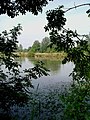 A Priory Pond^ - geograph.org.uk - 48556.jpg 482 × 640; 119 KB
-
 A sea of boulders at Blackstone Edge - geograph.org.uk - 271260.jpg 1,600 × 1,200; 561 KB
-
 A Strange Visitor - geograph.org.uk - 452924.jpg 640 × 480; 107 KB
-

-
 A436 at Kilkenny - geograph.org.uk - 48370.jpg 640 × 480; 92 KB
-
 A65 Junction - geograph.org.uk - 48675.jpg 640 × 480; 157 KB
-
 A65 junction - geograph.org.uk - 48694.jpg 640 × 480; 146 KB
-
 A85, Loch Earn - geograph.org.uk - 48533.jpg 640 × 480; 66 KB
-
 Abandoned Railway at Threshfield - geograph.org.uk - 49242.jpg 640 × 480; 75 KB
-
 Across the Corrie of the Scotsman - geograph.org.uk - 1281833.jpg 640 × 480; 60 KB
-
 Albert Dock and the Three Graces - geograph.org.uk - 674758.jpg 480 × 621; 122 KB
-
 All Saints Church, Bolton - geograph.org.uk - 49529.jpg 640 × 480; 76 KB
-
 All Saints Church, Sherburn in Elmet.jpg 640 × 476; 102 KB
-
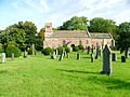
 All Saints' church, Eagle, Lincs. - geograph.org.uk - 48459.jpg 640 × 480; 99 KB
-
 An old Lime Kiln at Loch an Eilein. - geograph.org.uk - 419702.jpg 640 × 427; 159 KB
-
 Arkelby Mill - geograph.org.uk - 48537.jpg 640 × 392; 103 KB
-
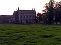 Arkleby Hall, Arkleby - geograph.org.uk - 48542.jpg 640 × 480; 114 KB
-
 Askrigg - geograph.org.uk - 54329.jpg 640 × 480; 114 KB
-
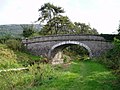 Atkinson's Bridge, Farleton - geograph.org.uk - 49614.jpg 640 × 480; 96 KB
-

-
 Bakers Lane byway (Causeway End) - geograph.org.uk - 48526.jpg 640 × 482; 73 KB
-
 Baldernock Parish Church, near Milngavie, East Dunbartonshire.jpg 640 × 480; 88 KB
-
 Barn at Tregolds, near St Merryn - geograph.org.uk - 50740.jpg 640 × 480; 215 KB
-
 Barns at Oaks Farm - geograph.org.uk - 48662.jpg 640 × 480; 78 KB
-
 Bassenthwaite Lake south end.jpg 640 × 480; 112 KB
-

-
 Beaford Bridge - geograph.org.uk - 49843.jpg 640 × 480; 150 KB
-
 Bealach an Easain - geograph.org.uk - 49683.jpg 640 × 480; 89 KB
-
 Beausale - geograph.org.uk - 50476.jpg 640 × 467; 114 KB
-
 Beausale Village Club - geograph.org.uk - 50477.jpg 640 × 480; 93 KB
-
 Bellman's Farm, Padham's Green - geograph.org.uk - 48331.jpg 640 × 332; 39 KB
-
 Workers' Housing - geograph.org.uk - 356552.jpg 635 × 508; 71 KB
-

-
 Berkswell and Balsall Rugby Club - geograph.org.uk - 49943.jpg 640 × 480; 101 KB
-

-
 Biddulph Grange Garden - geograph.org.uk - 48567.jpg 528 × 640; 188 KB
-
 Biddulph Grange Garden - geograph.org.uk - 48582.jpg 620 × 436; 157 KB
-
 Big Wood - geograph.org.uk - 49137.jpg 640 × 480; 97 KB
-
 Blackstone Edge Fold farm - geograph.org.uk - 99203.jpg 640 × 480; 129 KB
-
 Blennerhasset, Village Green - geograph.org.uk - 48549.jpg 640 × 424; 102 KB
-
 Bmi.a319-100.g-dbca.arp.jpg 1,780 × 1,120; 909 KB
-
 Bolton - geograph.org.uk - 56186.jpg 640 × 480; 58 KB
-
 Bolton Bridge over the River Eden - geograph.org.uk - 49532.jpg 640 × 480; 74 KB
-
 Braeside Park, Balloch - geograph.org.uk - 371454.jpg 640 × 427; 75 KB
-
 Bransholme Housing Estate - geograph.org.uk - 49206.jpg 480 × 640; 69 KB
-
 Bridge 115, Garsdale Head - geograph.org.uk - 76809.jpg 640 × 480; 68 KB
-
 Bridge of Orchy Junction - geograph.org.uk - 48585.jpg 640 × 440; 94 KB
-
 Bridge of Orchy Road Junction - geograph.org.uk - 48598.jpg 640 × 436; 71 KB
-
 Bridgewater canal Bridge - geograph.org.uk - 49166.jpg 640 × 480; 133 KB
-
 Britaw.b747-400.g-bnlo.arp.jpg 1,800 × 1,148; 405 KB
-
 British Airways B747-400 G-BNLO.jpg 1,800 × 1,148; 398 KB
-
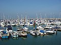 Brixham Marina - geograph.org.uk - 48408.jpg 640 × 480; 94 KB
-
 Broad Head Drain - geograph.org.uk - 99208.jpg 1,600 × 1,200; 451 KB
-
 Buittle Cemetery - geograph.org.uk - 697698.jpg 640 × 480; 95 KB
-
 Burghley House - geograph.org.uk - 264731.jpg 640 × 480; 71 KB
-
 Burnham Out to Sea - panoramio.jpg 500 × 375; 65 KB
-
 Burnham Sea Wall - panoramio.jpg 500 × 375; 83 KB
-
 Buttsbury Church - St Marys - geograph.org.uk - 48328.jpg 640 × 480; 120 KB
-
 Byway to Warner's Farm - geograph.org.uk - 48492.jpg 482 × 640; 153 KB
-
 Caerphilly Station - geograph.org.uk - 3333042.jpg 1,024 × 692; 931 KB
-
 Cairn on the shoulder of Ward Law - geograph.org.uk - 48561.jpg 640 × 480; 76 KB
-
 Cannizaro House, Wimbledon - geograph.org.uk - 1417756.jpg 640 × 480; 64 KB
-
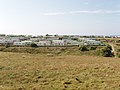
 Caravan Park, Greatstone-On-Sea - geograph.org.uk - 683629.jpg 640 × 480; 55 KB
-
 Caravan site at Mother Ivey's Bay - geograph.org.uk - 50620.jpg 640 × 480; 102 KB
-
 Carlam Hill Farm - geograph.org.uk - 49207.jpg 640 × 480; 98 KB
-
 Carnforth Station - geograph.org.uk - 48655.jpg 640 × 480; 117 KB
-
 Cars and cattle approaching Mochrum - geograph.org.uk - 567675.jpg 640 × 479; 130 KB
-

-
 Carting it away^ - geograph.org.uk - 48573.jpg 640 × 480; 94 KB
-
 Cataclews Point, by Harlyn Bay - geograph.org.uk - 50646.jpg 640 × 480; 111 KB
-
 Chapel at Hartpury - geograph.org.uk - 631771.jpg 640 × 426; 79 KB
-
 Chapel at Hartpury - geograph.org.uk - 631774.jpg 640 × 426; 57 KB
-
 Chelmer at Springfield - geograph.org.uk - 48559.jpg 482 × 640; 97 KB
-
 Chelmer from the A130 - geograph.org.uk - 48488.jpg 482 × 640; 124 KB
-
 Chelmer Park - geograph.org.uk - 48299.jpg 640 × 427; 62 KB
-
 Chesil railway tunnel entrance.jpg 640 × 480; 94 KB
-

-
 Clawthorpe Hall Business Centre - geograph.org.uk - 49626.jpg 640 × 480; 73 KB
-
 Clay Lane - geograph.org.uk - 92536.jpg 640 × 480; 82 KB
-
 Clay Lane - geograph.org.uk - 92542.jpg 480 × 640; 192 KB
-
 Cliffe Pools Panorama - geograph.org.uk - 104147.jpg 640 × 308; 63 KB
-
 Cock Green - geograph.org.uk - 48514.jpg 640 × 482; 103 KB
-
 Cod Rock and Mew Stone - geograph.org.uk - 48411.jpg 640 × 480; 87 KB
-
 Collinpark Wood - geograph.org.uk - 49257.jpg 640 × 426; 168 KB
-
 Compton Green - geograph.org.uk - 49260.jpg 640 × 426; 141 KB
-
 Corsend Farm, Hartpury - geograph.org.uk - 49243.jpg 640 × 426; 112 KB
-
 Cow at Freiston Shore - geograph.org.uk - 1010890.jpg 2,048 × 1,536; 1.47 MB
-
 Cowes Roads - geograph.org.uk - 81920.jpg 640 × 480; 141 KB
-
 Creag Each - geograph.org.uk - 48611.jpg 640 × 480; 59 KB
-
 Cricket at the Steelworks - geograph.org.uk - 48576.jpg 640 × 480; 63 KB
-

-

-
 Crossmichael Church and graveyard - geograph.org.uk - 697892.jpg 640 × 480; 65 KB
-
 Dew Pond, Ditchling Beacon - geograph.org.uk - 48421.jpg 640 × 479; 119 KB
-
 Dock Tarn, Watendlath Fell - geograph.org.uk - 904862.jpg 640 × 487; 147 KB
-
 Dundurn.jpg 640 × 480; 57 KB
-
 Dunston - geograph.org.uk - 48290.jpg 640 × 480; 133 KB
-
 Eagle War Memorial - geograph.org.uk - 48457.jpg 480 × 640; 113 KB
-
 East Mill - geograph.org.uk - 356562.jpg 637 × 421; 57 KB
-
 East Mill - geograph.org.uk - 356572.jpg 633 × 434; 70 KB
-
 Ere the Winter Storms Begin - geograph.org.uk - 48571.jpg 640 × 480; 83 KB
-
 Eroding peat at Sun End - geograph.org.uk - 99426.jpg 1,600 × 1,200; 1.06 MB
-
 Exposed peat and blazing heather - geograph.org.uk - 99516.jpg 1,600 × 1,200; 466 KB
-
 Farmland, Abbott's Barton, Winchester - geograph.org.uk - 48530.jpg 640 × 480; 54 KB
-
 Fishing boats on Beer beach - geograph.org.uk - 82697.jpg 640 × 480; 132 KB
-
 Flagged section of Pennine Way, Langfield Common - geograph.org.uk - 99529.jpg 1,600 × 1,200; 541 KB
-
 Flecket Hill - geograph.org.uk - 74579.jpg 600 × 450; 91 KB
-
 Footpath along embankment near Light Hazzles Reservoir - geograph.org.uk - 99500.jpg 1,600 × 1,200; 531 KB
-
 Footpath and driveway - geograph.org.uk - 48657.jpg 640 × 480; 82 KB
-
 Footpath and Pauntley Court - geograph.org.uk - 49264.jpg 640 × 426; 147 KB
-

-
 Footpath through the maize - geograph.org.uk - 57697.jpg 640 × 480; 272 KB
-
 Footpath to Stonethwaite - geograph.org.uk - 904867.jpg 640 × 460; 104 KB
-
 Forgan Church - geograph.org.uk - 48666.jpg 640 × 438; 116 KB
-
 Fowler Ploughing Engines - geograph.org.uk - 291866.jpg 640 × 480; 62 KB
-

-
 Fruid Dam - geograph.org.uk - 74661.jpg 600 × 450; 95 KB
-
 Gardens on the Burghley House Estate - geograph.org.uk - 264742.jpg 640 × 480; 55 KB
-

-
 Gate entrance to Ormiston House - geograph.org.uk - 48553.jpg 640 × 480; 205 KB
-
 Giggleswick Art Department - geograph.org.uk - 231359.jpg 640 × 286; 110 KB
-
 Glen Prosen Village Kirk - geograph.org.uk - 67385.jpg 640 × 480; 128 KB
-
 Gloucestershire Way near St Paul's Epistle - geograph.org.uk - 48388.jpg 640 × 480; 165 KB
-
 Green Screening - geograph.org.uk - 49807.jpg 640 × 480; 176 KB
-
 Gulland Rock from Harlyn Bay - geograph.org.uk - 50656.jpg 480 × 640; 128 KB
-
 Hackley Bay - geograph.org.uk - 108335.jpg 640 × 480; 83 KB
-
 Hampton Wick Station - geograph.org.uk - 818792.jpg 640 × 457; 114 KB
-
 Harbour, Isle of Whithorn - geograph.org.uk - 567688.jpg 640 × 479; 86 KB
-
 Hartpury Mill - geograph.org.uk - 49244.jpg 640 × 426; 162 KB
-
 Harvesting - geograph.org.uk - 48574.jpg 640 × 480; 96 KB
-
 Hasfield Church - geograph.org.uk - 49230.jpg 426 × 640; 132 KB
-
 Hawbridge over the River Severn - geograph.org.uk - 49823.jpg 640 × 426; 129 KB
-
 St Mary, Hellesdon, Norfolk - geograph.org.uk - 319655.jpg 640 × 480; 109 KB
-
 High Bransholme - geograph.org.uk - 49204.jpg 640 × 480; 88 KB
-
 Hill to west of Sun End - geograph.org.uk - 99440.jpg 1,600 × 1,200; 438 KB
-
 Holderness Drain - geograph.org.uk - 49202.jpg 640 × 480; 134 KB
-
 Horse in the mist - Flickr - thekeithhall.jpg 2,048 × 1,536; 1.71 MB
-
 Humphrey Head from the south - geograph.org.uk - 48658.jpg 640 × 480; 103 KB
-
 Inniscord Loch - geograph.org.uk - 437923.jpg 640 × 480; 114 KB
-
 Interior of Hartpury church - geograph.org.uk - 631780.jpg 640 × 426; 74 KB
-
 Interior of Upleadon Church - geograph.org.uk - 630397.jpg 426 × 640; 52 KB
-
 Interior of Upleadon Church - geograph.org.uk - 630401.jpg 426 × 640; 67 KB
-
 Invercauld House - panoramio.jpg 2,048 × 1,536; 802 KB
-
 Isle of Wight 2005-09-03.jpg 1,244 × 683; 755 KB
-
 Junction of Pennine Way and Long Causeway - geograph.org.uk - 99541.jpg 1,600 × 1,200; 1.11 MB
-
 Kent Viaduct from Arnside - geograph.org.uk - 48656.jpg 640 × 480; 88 KB
-
 Kirkby Malham Church - geograph.org.uk - 48831.jpg 480 × 640; 91 KB
-
 Kirkstyle Inn, Knarsdale - geograph.org.uk - 485530.jpg 640 × 480; 90 KB
-
 La Crêperie de Hampstead - 2005.jpg 2,560 × 1,920; 3.04 MB
-
 Langber Lane - geograph.org.uk - 48813.jpg 640 × 480; 165 KB
-
 Langdon Park - geograph.org.uk - 819221.jpg 640 × 457; 107 KB
-
 Libyan.arab.airlines.a320-200.ts-inj.london.arp.jpg 1,600 × 1,072; 267 KB
-
 Lion Farm, Beausale - geograph.org.uk - 49946.jpg 640 × 480; 124 KB
-
 Llyn Crafnant - geograph.org.uk - 51674.jpg 640 × 427; 116 KB
-
 Loch Dubh - geograph.org.uk - 48387.jpg 640 × 480; 115 KB
-
 Loch Earn.jpg 629 × 425; 49 KB
-
 London Hill - geograph.org.uk - 48400.jpg 640 × 480; 103 KB
-
 Long Row - geograph.org.uk - 356538.jpg 637 × 418; 60 KB
-

-
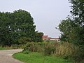
 Lower House - geograph.org.uk - 49246.jpg 640 × 426; 152 KB
-
 Lyme Park Lantern.jpg 640 × 480; 111 KB
-
 Lymm Dam - geograph.org.uk - 49101.jpg 640 × 480; 52 KB
-
 Lymm Dam - geograph.org.uk - 49103.jpg 640 × 480; 68 KB
-
 Lymm Dam Panorama - geograph.org.uk - 49106.jpg 640 × 171; 25 KB
-
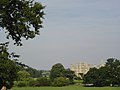
 Main Entrance, Normansfield - geograph.org.uk - 49895.jpg 640 × 480; 208 KB
-
 Marconi Radar Tower - geograph.org.uk - 48310.jpg 427 × 640; 68 KB
-
 Marion and Stormin' Norman - geograph.org.uk - 949064.jpg 640 × 480; 69 KB
-

-
 Meall na h-Eilde - geograph.org.uk - 49679.jpg 640 × 480; 98 KB
-
 Meikle Bin - geograph.org.uk - 162821.jpg 640 × 480; 73 KB
-
 Meripilus giganteus - geograph.org.uk - 49898.jpg 640 × 480; 253 KB
-
 Mile End Hospital, East London - geograph.org.uk - 48350.jpg 640 × 480; 79 KB
-
 Mile End Lock, Regent's Canal, East London - geograph.org.uk - 48355.jpg 640 × 480; 129 KB
-
 Mill Loch Holm - geograph.org.uk - 430641.jpg 640 × 316; 36 KB
-
 Mobile homes at Station Fields - geograph.org.uk - 48318.jpg 640 × 480; 144 KB
-
 Mother Ivey's Bay - geograph.org.uk - 50622.jpg 480 × 640; 106 KB
-
 Mull of Galloway 05-09-03 33.jpeg 1,800 × 1,350; 904 KB
-
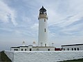 Mull of Galloway Lighthouse 05-09-03 14.jpeg 1,900 × 1,425; 617 KB
-
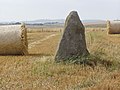 Mundurno Standing Stone - geograph.org.uk - 931969.jpg 640 × 480; 92 KB
-
 Nash Point - geograph.org.uk - 87206.jpg 640 × 480; 92 KB
-
 Norman arch, Pauntley Church - geograph.org.uk - 630578.jpg 426 × 640; 113 KB
-
 Normansfield Hospital - geograph.org.uk - 819136.jpg 640 × 457; 82 KB
-
 Normansfield Park - geograph.org.uk - 49808.jpg 640 × 480; 166 KB
-
 Normansfield Park - geograph.org.uk - 49896.jpg 640 × 441; 212 KB
-
 Normansfield Theatre - geograph.org.uk - 49803.jpg 640 × 418; 199 KB
-
 Normansfield Theatre Stage - geograph.org.uk - 49802.jpg 640 × 432; 187 KB
-

-

-
 Orms Gill Green - geograph.org.uk - 48815.jpg 640 × 480; 152 KB
-
 Park House - geograph.org.uk - 49023.jpg 640 × 480; 132 KB
-

-
 Pauntley Church - geograph.org.uk - 116733.jpg 426 × 640; 119 KB
-
 Pauntley Church - geograph.org.uk - 49262.jpg 640 × 426; 138 KB
-
 Pauntley Church - geograph.org.uk - 630581.jpg 426 × 640; 79 KB
-
 Pauntley Church and Dovecote - geograph.org.uk - 630582.jpg 640 × 426; 71 KB


_-_geograph.org.uk_-_48526.jpg)


