Category:United Kingdom photographs taken on 2006-02-11
Countries of Europe: Austria · Croatia · Denmark · Finland · France‡ · Germany · Italy · Latvia · Lithuania · Netherlands‡ · Poland · Portugal‡ · Russia‡ · Serbia · Slovakia · Spain‡ · Sweden · Switzerland · Turkey‡ · United Kingdom
Specific status: Isle of Man
‡: partly located in Europe
Specific status: Isle of Man
‡: partly located in Europe
| ← | Saturday 11 February 2006 | → | ||
| ← | February 2006 | → | ||

United Kingdom photographs taken on 11 February 2006.
Image files should be categorized here automatically using {{taken on}} template. Direct categorisation is also possible, if automatic is impossible.
Subcategories
This category has the following 2 subcategories, out of 2 total.
Media in category "United Kingdom photographs taken on 2006-02-11"
The following 200 files are in this category, out of 509 total.
(previous page) (next page)-
 "I jumped" - Flickr - Fin Fahey.jpg 487 × 640; 93 KB
-
 "One" Railway Looking Towards Rayleigh - geograph.org.uk - 120402.jpg 640 × 480; 117 KB
-

-
 A Terrace of Houses, Hornsea - geograph.org.uk - 660070.jpg 640 × 480; 56 KB
-
 A46 Junction to Cotgrave and Owthorpe - geograph.org.uk - 120399.jpg 640 × 480; 107 KB
-
 A46 Junction to Widmerpool and Kinoulton - geograph.org.uk - 120407.jpg 640 × 427; 115 KB
-
 A55 at Gaerwen intersection - geograph.org.uk - 120634.jpg 640 × 480; 48 KB
-
 A816 approaching Oban from the south. - geograph.org.uk - 120760.jpg 640 × 480; 51 KB
-

-
 Aberdeen Angus - geograph.org.uk - 128347.jpg 640 × 480; 99 KB
-
 St Mildred's Church, Bingham Road - geograph.org.uk - 220201.jpg 640 × 480; 79 KB
-
 Aislaby, nr Whitby.jpg 640 × 480; 79 KB
-
 All Saints Stibbard.jpg 640 × 406; 95 KB
-
 All Saints, Bale, Norfolk - geograph.org.uk - 320346.jpg 473 × 640; 177 KB
-
 All Saints, Bale, Norfolk - geograph.org.uk - 320348.jpg 640 × 496; 125 KB
-
 All Saints, Bale, Norfolk - geograph.org.uk - 320349.jpg 640 × 480; 103 KB
-
 All Saints, Stibbard, Norfolk - geograph.org.uk - 320372.jpg 640 × 398; 95 KB
-
 Arable Field at Skelder Hill Farm - geograph.org.uk - 120517.jpg 640 × 480; 89 KB
-
 Arena tram junction.jpg 640 × 480; 84 KB
-
 Army Cadet building - geograph.org.uk - 127504.jpg 640 × 480; 50 KB
-
 Aylestone packhorse bridge - geograph.org.uk - 121481.jpg 640 × 480; 118 KB
-

-
 Balkholme.jpg 640 × 480; 194 KB
-
 Barbarafield Farm - geograph.org.uk - 120511.jpg 640 × 392; 58 KB
-
 Beechwood Cross - geograph.org.uk - 120563.jpg 640 × 427; 126 KB
-
 Bentalls Centre - geograph.org.uk - 120618.jpg 640 × 480; 100 KB
-
 Beside Craigrothie Burn - geograph.org.uk - 120519.jpg 640 × 480; 94 KB
-

-
 Black Hill - geograph.org.uk - 120332.jpg 640 × 480; 53 KB
-
 Black Hill car dealership - geograph.org.uk - 120871.jpg 640 × 480; 44 KB
-
 Blythe Hill Tavern - geograph.org.uk - 120334.jpg 640 × 465; 86 KB
-
 Bogs of Mayne Memorial near Elgin - geograph.org.uk - 121216.jpg 640 × 480; 83 KB
-
-
 Bridge No. TJG2-2 - geograph.org.uk - 121399.jpg 640 × 480; 195 KB
-
 Bridge on the Calderdale Way - geograph.org.uk - 1748594.jpg 2,272 × 1,712; 1.25 MB
-
 Brinklow Church - geograph.org.uk - 172603.jpg 427 × 640; 70 KB
-
 Burn at Auchtermuchty - geograph.org.uk - 120687.jpg 640 × 480; 138 KB
-
 Canvey Point - geograph.org.uk - 120367.jpg 640 × 231; 23 KB
-
 Carn Dearg - geograph.org.uk - 121309.jpg 640 × 480; 65 KB
-
 Catholic church of St Walstan, Costessey - geograph.org.uk - 120395.jpg 640 × 480; 287 KB
-
 Catholic church of St Walstan, Costessey.jpg 463 × 349; 111 KB
-
 Chapel in Gaerwen - geograph.org.uk - 120557.jpg 640 × 480; 53 KB
-
 Chichester Hall Hotel - geograph.org.uk - 120378.jpg 640 × 480; 81 KB
-

-
 Christ Church, Fulmodeston, Norfolk - geograph.org.uk - 320373.jpg 640 × 480; 144 KB
-
 Christians in Action, Parkview Road - geograph.org.uk - 220202.jpg 640 × 480; 96 KB
-
 Church of the Good Shepherd - geograph.org.uk - 120370.jpg 480 × 640; 176 KB
-
 Clapham Village Hall - geograph.org.uk - 749174.jpg 640 × 426; 58 KB
-
 Coast Artillery School - remains - geograph.org.uk - 122370.jpg 640 × 480; 46 KB
-
 College Ride, Camberley - geograph.org.uk - 121659.jpg 640 × 480; 81 KB
-
 College Road, College Town - geograph.org.uk - 121608.jpg 640 × 480; 91 KB
-
 Converted chapel in Llanddaniel Fab - geograph.org.uk - 120552.jpg 640 × 480; 61 KB
-
 Converted church, Taymount Rise - geograph.org.uk - 219413.jpg 640 × 480; 111 KB
-
 Corehead Farm below the Devils Beeftub - geograph.org.uk - 194598.jpg 640 × 480; 106 KB
-
 Costessey weir - geograph.org.uk - 120379.jpg 640 × 480; 218 KB
-
 Costessey.JPG 480 × 640; 244 KB
-
 Cotness Farmland - geograph.org.uk - 121394.jpg 640 × 480; 166 KB
-
 Cottages - geograph.org.uk - 120468.jpg 640 × 480; 54 KB
-
 Cottages at Tai Rhos - geograph.org.uk - 120570.jpg 640 × 480; 64 KB
-
 Craig y don - geograph.org.uk - 122489.jpg 640 × 480; 40 KB
-
 Craigrothie - geograph.org.uk - 120506.jpg 640 × 438; 51 KB
-
 Crossroads on the A30 - geograph.org.uk - 120648.jpg 640 × 480; 271 KB
-
 Crowthorne Road, Sandhurst - geograph.org.uk - 121650.jpg 640 × 480; 89 KB
-
 Cut down hedgerow trees - geograph.org.uk - 120555.jpg 640 × 427; 118 KB
-
 Dale Street methodist church rooms - geograph.org.uk - 127431.jpg 640 × 480; 58 KB
-
 Deep Sea World - geograph.org.uk - 230398.jpg 553 × 640; 52 KB
-
 Deer Park Equestrian Centre, Brockhampton - geograph.org.uk - 120417.jpg 640 × 426; 131 KB
-
 Derelict Car Dealers - geograph.org.uk - 120351.jpg 640 × 480; 51 KB
-
 Derelict cottage in Whittington - geograph.org.uk - 120852.jpg 640 × 426; 132 KB
-
 Derelict Filling Station - geograph.org.uk - 120881.jpg 640 × 480; 43 KB
-
 Descending from Windmill Hill - geograph.org.uk - 120699.jpg 640 × 480; 246 KB
-
 Disused Lawn Roller, The Moors Centre - geograph.org.uk - 120545.jpg 640 × 427; 76 KB
-
 Doublegate Lane, Shotgate - geograph.org.uk - 120392.jpg 640 × 480; 77 KB
-
 Drybridge Station - geograph.org.uk - 120494.jpg 640 × 480; 140 KB
-
 Duck Bridge, Topstone Farm - geograph.org.uk - 120528.jpg 640 × 480; 65 KB
-
 Dyke, Carn Dearg. - geograph.org.uk - 121303.jpg 508 × 640; 87 KB
-
 East Berkshire Golf Club - geograph.org.uk - 121640.jpg 640 × 480; 95 KB
-
 East end of St George's - geograph.org.uk - 845376.jpg 640 × 480; 145 KB
-
 Eastrington railway station.jpg 640 × 480; 107 KB
-
 End of the Orme - geograph.org.uk - 122363.jpg 640 × 480; 50 KB
-

-
 Ey Burn. - geograph.org.uk - 121276.jpg 640 × 480; 114 KB
-
 Ey Burn. - geograph.org.uk - 121315.jpg 640 × 456; 66 KB
-
 Ey Burn. - geograph.org.uk - 121341.jpg 640 × 499; 91 KB
-
 Fallen tree, Pitmedden Forest - geograph.org.uk - 120427.jpg 640 × 480; 67 KB
-
 Farmland at SE774253 - geograph.org.uk - 121404.jpg 640 × 480; 159 KB
-
 Farmland at SE838278 - geograph.org.uk - 121390.jpg 640 × 480; 157 KB
-
 Farmland at SE872301 - geograph.org.uk - 121389.jpg 640 × 480; 166 KB
-
 Field near Tai Hirion - geograph.org.uk - 120714.jpg 640 × 480; 58 KB
-
 Fields at Pitmedden - geograph.org.uk - 120410.jpg 640 × 480; 116 KB
-
 Fields of Acton Beauchamp - geograph.org.uk - 120425.jpg 640 × 479; 58 KB
-

-
 Footpath by the Mere, Hornsea - geograph.org.uk - 660080.jpg 640 × 480; 80 KB
-
 Footpath enters forest - geograph.org.uk - 121436.jpg 640 × 427; 121 KB
-
 Forest Hill Fire Station - geograph.org.uk - 120346.jpg 640 × 453; 63 KB
-
 Forest path - geograph.org.uk - 120513.jpg 640 × 480; 70 KB
-
 Forest road - geograph.org.uk - 120474.jpg 640 × 480; 60 KB
-
 Forest track - geograph.org.uk - 120694.jpg 640 × 480; 73 KB
-

-
 Former church, Augusta Place - geograph.org.uk - 127439.jpg 480 × 640; 52 KB
-
 Frozen pond, Pitmedden Forest - geograph.org.uk - 120453.jpg 640 × 480; 67 KB
-
 Fulstow Village Hall - geograph.org.uk - 131297.jpg 640 × 480; 103 KB
-

-
 Gate entrance to farm livestock. - geograph.org.uk - 120848.jpg 640 × 480; 145 KB
-

-

-
 German visitor to Popham - geograph.org.uk - 120647.jpg 640 × 480; 68 KB
-
 Glanwydden - geograph.org.uk - 122496.jpg 640 × 480; 33 KB
-
 Glassart Burn - geograph.org.uk - 120495.jpg 480 × 640; 77 KB
-
 Glassart Den Community Woodland - geograph.org.uk - 120682.jpg 640 × 480; 154 KB
-
 Goats and cottage, Pitmedden - geograph.org.uk - 120465.jpg 640 × 480; 70 KB
-
 Going for a lunchtime pint? - geograph.org.uk - 120681.jpg 640 × 480; 101 KB
-
 Great Orme - geograph.org.uk - 122368.jpg 640 × 480; 49 KB
-
 Great Orme Cliffs - geograph.org.uk - 122372.jpg 640 × 480; 34 KB
-
 Gunton Lane, Costessey - geograph.org.uk - 120411.jpg 640 × 480; 267 KB
-
 Halifax Bomber Disaster Balkholme.jpg 640 × 480; 100 KB
-
 Halifax Bomber Memorial Plaque.jpg 480 × 640; 113 KB
-
 Hangar at RAF Milltown. - geograph.org.uk - 121280.jpg 640 × 480; 105 KB
-
 Heathland near Sandhurst - geograph.org.uk - 121598.jpg 640 × 480; 77 KB
-
 Hemerdon Village - geograph.org.uk - 120576.jpg 640 × 415; 82 KB
-
 St Martin Parish Church, Hindringham.jpg 397 × 640; 114 KB
-
 St Martin, Hindringham, Norfolk - geograph.org.uk - 320342.jpg 640 × 478; 112 KB
-
 St Martin, Hindringham, Norfolk - geograph.org.uk - 320343.jpg 640 × 482; 93 KB
-
 Holy Trinity Church Hall - geograph.org.uk - 127476.jpg 640 × 480; 69 KB
-
 Home Farm Plantation - geograph.org.uk - 660106.jpg 640 × 480; 137 KB
-
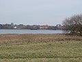 Hornsea Mere - geograph.org.uk - 660089.jpg 640 × 480; 62 KB
-
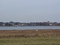 Hornsea Mere - geograph.org.uk - 660095.jpg 640 × 480; 46 KB
-
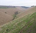 Horse Dale - geograph.org.uk - 121663.jpg 640 × 584; 110 KB
-
 How's that for a Bog - geograph.org.uk - 121053.jpg 640 × 480; 64 KB
-
 Jersey Marine Beach - geograph.org.uk - 461059.jpg 640 × 480; 57 KB
-
 Jersey Marine Beach - geograph.org.uk - 461077.jpg 640 × 480; 52 KB
-
 Jointure Farm. - geograph.org.uk - 121290.jpg 640 × 480; 120 KB
-
 Kilpin - geograph.org.uk - 121406.jpg 640 × 480; 140 KB
-
 King's Ride, Camberley - geograph.org.uk - 121621.jpg 640 × 480; 88 KB
-
 Kingsley Junior School - geograph.org.uk - 127486.jpg 640 × 480; 74 KB
-
 Kingsley School Sixth Form Centre - geograph.org.uk - 127492.jpg 640 × 480; 54 KB
-

-
 Laigh Milton Viaduct - geograph.org.uk - 120514.jpg 640 × 480; 80 KB
-
 Larches, Pitmedden Forest - geograph.org.uk - 120458.jpg 640 × 480; 77 KB
-
 Laxton.jpg 640 × 480; 155 KB
-

-
 Leigh Beck, Canvey Island - geograph.org.uk - 120369.jpg 640 × 480; 41 KB
-
 Lighthouse at Hurst Castle seen at dusk - geograph.org.uk - 120898.jpg 640 × 427; 102 KB
-
 Little Sparta track - geograph.org.uk - 120527.jpg 480 × 640; 112 KB
-
 Little Sparta woodland - geograph.org.uk - 120529.jpg 640 × 480; 79 KB
-
 Llangaffo Church - geograph.org.uk - 120582.jpg 640 × 480; 51 KB
-
 St Hilary's - geograph.org.uk - 122486.jpg 640 × 480; 68 KB
-
 Loch Assynt - geograph.org.uk - 120938.jpg 640 × 480; 59 KB
-
-
 Loch Leitir Easaidh - geograph.org.uk - 120951.jpg 640 × 480; 71 KB
-
 Loch Leitir Easaidh - geograph.org.uk - 121045.jpg 640 × 480; 62 KB
-
 Loch Leitir Easaidh - geograph.org.uk - 121049.jpg 640 × 480; 35 KB
-

-
 Loch na h- lnnse fraoich - geograph.org.uk - 121061.jpg 640 × 480; 53 KB
-
 Lock Lane, Sandiacre - geograph.org.uk - 199570.jpg 640 × 480; 48 KB
-
 Look-out - geograph.org.uk - 122371.jpg 640 × 480; 49 KB
-
 Looking at Quinag from the Road - geograph.org.uk - 120921.jpg 640 × 480; 92 KB
-

-
 Looking Towards Lochan an Ais - geograph.org.uk - 120859.jpg 640 × 480; 72 KB
-
 Looking West along Loch Assynt - geograph.org.uk - 120904.jpg 640 × 480; 67 KB
-
 Malt House, Perry Green - geograph.org.uk - 120973.jpg 640 × 426; 117 KB
-
 Marker Post, Lealholm Rigg - geograph.org.uk - 120471.jpg 640 × 480; 67 KB
-
 Metham Hall.jpg 640 × 480; 194 KB
-
 Milepost Near Skelder Wood Car Park - geograph.org.uk - 120508.jpg 640 × 480; 77 KB
-
 Milepost on the Cloud Trail - geograph.org.uk - 120836.jpg 480 × 640; 93 KB
-
 Mill Barn, Irby Hill Farm - geograph.org.uk - 120611.jpg 640 × 480; 57 KB
-
 Minor road to Windmill Hill - geograph.org.uk - 120693.jpg 480 × 640; 363 KB
-

-

-
 Nags Head Postbox - geograph.org.uk - 561666.jpg 640 × 480; 109 KB
-
 Near Common Farm - geograph.org.uk - 121388.jpg 640 × 480; 190 KB
-
 Near Gogarth - geograph.org.uk - 122367.jpg 640 × 480; 27 KB
-
 Near Lasborough. - panoramio.jpg 2,560 × 1,920; 2.36 MB
-
 Newbiggin Hall - geograph.org.uk - 120499.jpg 640 × 480; 55 KB
-
 Newly Planted Field - geograph.org.uk - 120466.jpg 640 × 427; 130 KB
-
 Newton's Row, Sparkwell - geograph.org.uk - 120498.jpg 640 × 427; 88 KB
-
 Norwich Road, Costessey - geograph.org.uk - 120416.jpg 640 × 480; 181 KB
-
 Oaklands Lane, Wokingham Without - geograph.org.uk - 121644.jpg 640 × 480; 88 KB
-
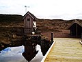
 Old cabin by Lake Vyrnwy - geograph.org.uk - 404692.jpg 640 × 424; 110 KB
-
 Old School House and Shop, Whittington - geograph.org.uk - 120446.jpg 640 × 426; 109 KB
-
 Old Shed - geograph.org.uk - 120558.jpg 640 × 480; 136 KB
-
 St Leonard's Church old Warden. - geograph.org.uk - 120306.jpg 640 × 475; 116 KB
-
 Parade of shops, Owlsmoor - geograph.org.uk - 121604.jpg 640 × 480; 83 KB
-
 Pasture at Priory Farm - geograph.org.uk - 1608948.jpg 640 × 438; 57 KB
-
 Pawnbrokers - geograph.org.uk - 126752.jpg 640 × 480; 62 KB
-
 Perry Green Lake Fishing Pond - geograph.org.uk - 120970.jpg 640 × 426; 149 KB
-
 Planning Notice, Coopers Farm - geograph.org.uk - 120479.jpg 640 × 480; 59 KB
-

-
 Playground, Stamford Gardens - geograph.org.uk - 127507.jpg 640 × 480; 97 KB
-
 Playing Fields at Filton - geograph.org.uk - 121419.jpg 640 × 480; 95 KB
-
 Popham - geograph.org.uk - 120640.jpg 640 × 480; 74 KB
-

-
 Public Right of Way Sign, Moorcock - geograph.org.uk - 120493.jpg 640 × 480; 51 KB
-
 Pylons in the Lea Valley - geograph.org.uk - 120845.jpg 640 × 480; 81 KB
-
 Quinag and a lovely old Road Bridge - geograph.org.uk - 120917.jpg 640 × 480; 122 KB
-
 Railway line - geograph.org.uk - 120566.jpg 640 × 480; 73 KB
-
 Railway line near to Star - geograph.org.uk - 120653.jpg 640 × 480; 67 KB
-
 Rathfern Primary School - geograph.org.uk - 120322.jpg 640 × 476; 81 KB
-
 Rayleigh Substation - geograph.org.uk - 120372.jpg 640 × 153; 29 KB
-
 Recycled Bath Tubs - geograph.org.uk - 120488.jpg 640 × 480; 83 KB


