Category:United Kingdom photographs taken on 2006-10-21
Countries of Europe: Andorra · Armenia‡ · Austria · Belgium · Czech Republic · Denmark · France‡ · Georgia‡ · Germany · Greece · Hungary · Republic of Ireland · Italy · Latvia · Netherlands‡ · Norway · Poland · Portugal‡ · Russia‡ · Serbia · Slovakia · Spain‡ · Sweden · Switzerland · Ukraine · United Kingdom
Specific status: Isle of Man
‡: partly located in Europe
Specific status: Isle of Man
‡: partly located in Europe
| ← | 21 October 2006 | → | ||
| ← | October 2006 | → | ||

United Kingdom photographs taken on 21 October 2006.
Image files should be categorized here automatically using {{taken on}} template. Direct categorisation is also possible, if automatic is impossible.
Subcategories
This category has only the following subcategory.
Media in category "United Kingdom photographs taken on 2006-10-21"
The following 200 files are in this category, out of 705 total.
(previous page) (next page)-
 "Holly Wood" - geograph.org.uk - 264219.jpg 640 × 480; 189 KB
-
 12 Charlston place Muirtown where we stayed for 3 years in the 70s - panoramio.jpg 2,816 × 2,120; 1.42 MB
-

-
 A74(M) - geograph.org.uk - 265754.jpg 640 × 480; 84 KB
-
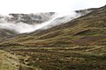
 Above the Back Burn - geograph.org.uk - 264367.jpg 640 × 480; 156 KB
-
 Above Warren Cottage - geograph.org.uk - 265631.jpg 640 × 480; 115 KB
-
 Across Toddle Moss to Harryburn Brae - geograph.org.uk - 265339.jpg 640 × 480; 80 KB
-
 Amanita muscaria on Pound Common - geograph.org.uk - 264175.jpg 640 × 480; 169 KB
-
 Amphilectus fucorum 7233939.jpg 2,048 × 1,362; 740 KB
-
 An Teallach from A'Mhaighdean - geograph.org.uk - 264220.jpg 640 × 432; 54 KB
-
 Anarchist Book Fair.jpg 2,592 × 1,944; 2.08 MB
-
 Anchor Bridge and Inn - geograph.org.uk - 264142.jpg 600 × 450; 216 KB
-
 Anglesey Abbey, Lode, Cambridgeshire.jpg 1,600 × 1,061; 1.46 MB
-
 Antennella secundaria 7233928.jpg 2,048 × 1,362; 709 KB
-
 Apple Days at Brogdale - geograph.org.uk - 264429.jpg 640 × 486; 97 KB
-
 Artigarvan, Strabane - geograph.org.uk - 306291.jpg 640 × 480; 132 KB
-
 Audlem fire station - geograph.org.uk - 266802.jpg 640 × 427; 229 KB
-
 Autumn colours in Glen Clunie - geograph.org.uk - 318393.jpg 600 × 399; 75 KB
-
 Autumn Footpath - geograph.org.uk - 888893.jpg 640 × 481; 165 KB
-
 Avon viaduct - geograph.org.uk - 1005295.jpg 640 × 480; 26 KB
-
 B4154, Rushall - geograph.org.uk - 264060.jpg 640 × 480; 97 KB
-
 B4154, Rushall - geograph.org.uk - 264061.jpg 640 × 480; 77 KB
-
 Ballymagorry - geograph.org.uk - 306284.jpg 640 × 480; 183 KB
-

-
 Barn at Lilling Hall Farm - geograph.org.uk - 264266.jpg 640 × 480; 125 KB
-
 Beach huts, Exmouth - geograph.org.uk - 264505.jpg 640 × 480; 63 KB
-
 Beside Wilding's Copse - geograph.org.uk - 265715.jpg 480 × 640; 122 KB
-
 Besthorpe Nature Reserve - geograph.org.uk - 264553.jpg 640 × 427; 46 KB
-
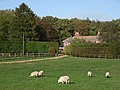
 Beware of sheep - geograph.org.uk - 265793.jpg 640 × 480; 86 KB
-
 Bewdley fire station - geograph.org.uk - 266871.jpg 640 × 427; 202 KB
-
 Birkenhead - geograph.org.uk - 264644.jpg 640 × 480; 140 KB
-
 Black Gutter Bottom - geograph.org.uk - 264814.jpg 640 × 480; 58 KB
-
 Bloxwich Cemetery - geograph.org.uk - 263996.jpg 500 × 375; 239 KB
-
 Blue Anchor railway station MMB 01.jpg 1,600 × 1,200; 317 KB
-
 Blue Anchor railway station MMB 02.jpg 1,600 × 1,200; 527 KB
-
 Blue Anchor railway station MMB 03 3850.jpg 1,600 × 1,200; 349 KB
-
 Blue Anchor railway station MMB 04.jpg 1,600 × 1,200; 317 KB
-
 Blue Anchor railway station MMB 05.jpg 1,600 × 1,200; 475 KB
-
 Boatmans Arms - geograph.org.uk - 264267.jpg 500 × 363; 168 KB
-
 Boats at Topsham - geograph.org.uk - 264491.jpg 480 × 640; 121 KB
-
 Bourton on the water - panoramio.jpg 2,592 × 1,944; 1.16 MB
-
 Bowling Green Marsh - geograph.org.uk - 264749.jpg 640 × 480; 72 KB
-
 Bressenden Place - geograph.org.uk - 264353.jpg 640 × 480; 124 KB
-
 Bridge Inn, Topsham - geograph.org.uk - 265859.jpg 640 × 480; 85 KB
-
 Bridge over Girnock Burn, Littlemill - geograph.org.uk - 337849.jpg 510 × 377; 110 KB
-
 Bridge over the Muckle Burn - geograph.org.uk - 264633.jpg 640 × 480; 197 KB
-
 Bridge over Water of Cruden - geograph.org.uk - 264560.jpg 640 × 480; 53 KB
-
 Bridgehill Garth, Topsham - geograph.org.uk - 265866.jpg 640 × 465; 77 KB
-
 Bridgend major road works - geograph.org.uk - 264559.jpg 640 × 480; 71 KB
-
 Bridleway East of Oakham Common - geograph.org.uk - 264136.jpg 640 × 480; 194 KB
-
 Bridleway into Great Spelty Wood - geograph.org.uk - 264462.jpg 640 × 480; 96 KB
-
 Bridleway on Pound Common - geograph.org.uk - 264165.jpg 640 × 480; 158 KB
-
 Bridleway on Telegraph Hill - geograph.org.uk - 264215.jpg 640 × 480; 193 KB
-
 Bromyard fire station - geograph.org.uk - 266862.jpg 640 × 427; 184 KB
-
 Burslem fire station - geograph.org.uk - 266819.jpg 640 × 427; 187 KB
-
 Bus terminus at Braemar - geograph.org.uk - 341915.jpg 640 × 466; 71 KB
-
 Cairn on Burbage Moor - geograph.org.uk - 264249.jpg 480 × 640; 114 KB
-
 Calgary Beach - geograph.org.uk - 269702.jpg 640 × 353; 55 KB
-
 Callater Burn in Glen Clunie - geograph.org.uk - 1504892.jpg 640 × 425; 125 KB
-
 Camps - geograph.org.uk - 264376.jpg 640 × 480; 87 KB
-
 Camps Dam - geograph.org.uk - 264387.jpg 640 × 480; 94 KB
-
 Camps Reservoir - geograph.org.uk - 264397.jpg 640 × 480; 26 KB
-
 Camps Reservoir - geograph.org.uk - 264401.jpg 640 × 480; 63 KB
-
 Camps Reservoir - geograph.org.uk - 264406.jpg 640 × 480; 89 KB
-
 Canalside allotments - geograph.org.uk - 264036.jpg 500 × 375; 198 KB
-
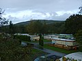 Caravan site in Irfon Valley, Garth - geograph.org.uk - 388709.jpg 640 × 480; 123 KB
-
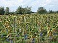
 Carrot crop protected with straw - geograph.org.uk - 264634.jpg 640 × 480; 195 KB
-
 Cattle, Warren Farm - geograph.org.uk - 265619.jpg 640 × 480; 139 KB
-
 Causeway, Topsham - geograph.org.uk - 264801.jpg 480 × 640; 96 KB
-
 Cemetery Crina Bottom - geograph.org.uk - 264529.jpg 480 × 640; 144 KB
-
 Chapel Place, Topsham - geograph.org.uk - 265816.jpg 480 × 640; 71 KB
-
 Chase Woods - geograph.org.uk - 265736.jpg 640 × 480; 141 KB
-
 Church at Upper Chapel - geograph.org.uk - 432280.jpg 640 × 480; 115 KB
-
 Church End House, Twyning - geograph.org.uk - 265946.jpg 640 × 480; 130 KB
-
 Church Hall in Totland - geograph.org.uk - 264336.jpg 640 × 480; 66 KB
-

-
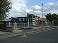 Clayhanger Church and School - geograph.org.uk - 264236.jpg 500 × 375; 150 KB
-
 Cleobury Mortimer fire station - geograph.org.uk - 266863.jpg 640 × 426; 214 KB
-
 Closing Down at Cozee Carpets - geograph.org.uk - 314111.jpg 640 × 431; 112 KB
-
 Clover on field margin - geograph.org.uk - 266129.jpg 640 × 479; 162 KB
-
-
 Commemorative Plaque - Hunters Sty - geograph.org.uk - 264305.jpg 427 × 640; 83 KB
-

-
 Control Tower, RAF Topcliffe - geograph.org.uk - 265072.jpg 640 × 480; 60 KB
-
 Coomb Dod summit - geograph.org.uk - 279750.jpg 640 × 480; 75 KB
-
 Copse, Woodlands Farm - geograph.org.uk - 265599.jpg 640 × 480; 107 KB
-
 Corbel, Topsham - geograph.org.uk - 264468.jpg 480 × 640; 51 KB
-
 Corpus Christi entrance Oxford.jpg 480 × 640; 100 KB
-
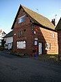
 Cottage beside Dyke Parish Church - geograph.org.uk - 264645.jpg 640 × 480; 179 KB
-
 Cottages on Church Road, Lympstone - geograph.org.uk - 264658.jpg 640 × 480; 110 KB
-
 Crewe fire station - geograph.org.uk - 266809.jpg 640 × 427; 214 KB
-
 Cromer House, Topsham - geograph.org.uk - 265806.jpg 640 × 492; 93 KB
-
 Cruwys Morchard, by Forke Farm - geograph.org.uk - 263922.jpg 640 × 427; 148 KB
-
 Cruwys Morchard, Forke Farm - geograph.org.uk - 263920.jpg 640 × 427; 206 KB
-
 Cruwys Morchard, Greenfield Cross - geograph.org.uk - 263916.jpg 640 × 427; 126 KB
-
 Cruwys Morchard, lane by Penn Coppice - geograph.org.uk - 263924.jpg 640 × 427; 315 KB
-
 Cruwys Morchard, near Pulsards Farm - geograph.org.uk - 263913.jpg 640 × 427; 179 KB
-
 Cruwys Morchard, Pennymoor - geograph.org.uk - 263940.jpg 640 × 427; 161 KB
-
 Culter Cleuch Shank - geograph.org.uk - 279779.jpg 640 × 480; 115 KB
-
 Cyclamen by the Goat Walk, Topsham - geograph.org.uk - 264757.jpg 640 × 480; 160 KB
-
 Dalvey Smithy Cottages - geograph.org.uk - 264589.jpg 640 × 480; 170 KB
-
 Deadman's Wood - geograph.org.uk - 265262.jpg 480 × 640; 158 KB
-
 Derelict Greenhouses - geograph.org.uk - 456563.jpg 640 × 361; 48 KB
-
 Disused clay pit - geograph.org.uk - 264356.jpg 550 × 412; 158 KB
-
 Disused public houses in Little Bloxwich - geograph.org.uk - 264537.jpg 600 × 450; 200 KB
-
 Downs, Ogbourne St George - geograph.org.uk - 265658.jpg 640 × 480; 116 KB
-
 Drinking fountain St Arvans - geograph.org.uk - 272620.jpg 480 × 640; 189 KB
-
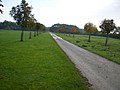
 Driveway to Thornton Grange Farm - geograph.org.uk - 264268.jpg 640 × 480; 114 KB
-
 Dungavel Hill - geograph.org.uk - 265782.jpg 640 × 393; 57 KB
-
 Dyke graveyard - geograph.org.uk - 264649.jpg 640 × 480; 159 KB
-
 Dyke Parish Church - geograph.org.uk - 264643.jpg 640 × 480; 152 KB
-
 Earnhill Farm - geograph.org.uk - 264635.jpg 640 × 480; 197 KB
-
 Earnhill House - geograph.org.uk - 264637.jpg 640 × 480; 154 KB
-

-
 Eas Fors - First Cataract - geograph.org.uk - 269712.jpg 480 × 640; 122 KB
-
 Eas Fors - Looking over the edge - geograph.org.uk - 282727.jpg 640 × 480; 127 KB
-
 Eas Fors - Second Cataract - geograph.org.uk - 269811.jpg 640 × 480; 151 KB
-
 Eas Fors - Third Cataract - geograph.org.uk - 269814.jpg 640 × 480; 134 KB
-
 East Lodge Dalvey House - geograph.org.uk - 264592.jpg 640 × 480; 202 KB
-
 Easy Way to Werneth Low - geograph.org.uk - 1077699.jpg 584 × 621; 135 KB
-
 Elizabeth Hall, Exmouth - geograph.org.uk - 265888.jpg 640 × 480; 101 KB
-
 Elm Grove School, Topsham - geograph.org.uk - 265863.jpg 480 × 640; 75 KB
-
 Emblem on Little Bloxwich Bridge - geograph.org.uk - 264547.jpg 640 × 480; 272 KB
-
 Entrance to Moy House - geograph.org.uk - 264620.jpg 640 × 480; 179 KB
-
 Esslemont Castle ruin - geograph.org.uk - 264577.jpg 640 × 480; 130 KB
-
 Estate gateposts and path sign - geograph.org.uk - 264618.jpg 640 × 480; 189 KB
-

-

-
 Exeter Airport terminal - geograph.org.uk - 264716.jpg 640 × 480; 94 KB
-
 Fabulous Furry Freaks - geograph.org.uk - 977171.jpg 640 × 480; 97 KB
-
 Farm Track - geograph.org.uk - 266127.jpg 640 × 480; 85 KB
-
 Farm Track Bridge - geograph.org.uk - 266121.jpg 640 × 480; 105 KB
-
 Farm Woodland - geograph.org.uk - 266128.jpg 640 × 379; 77 KB
-
 Farmland above Ogbourne St George - geograph.org.uk - 265656.jpg 640 × 480; 140 KB
-
 Farmland and Chase Wood - geograph.org.uk - 265744.jpg 640 × 480; 110 KB
-
 Farmland and copse, Mildenhall Warren - geograph.org.uk - 265617.jpg 640 × 480; 110 KB
-
 Farmland and wood above Aldbourne - geograph.org.uk - 265786.jpg 640 × 480; 79 KB
-
 Farmland near Ogbourne St George - geograph.org.uk - 265634.jpg 640 × 480; 116 KB
-
 Farmland near Ogbourne St George - geograph.org.uk - 265644.jpg 640 × 480; 109 KB
-
 Farr Wind Farm - geograph.org.uk - 265849.jpg 480 × 640; 35 KB
-
 Farthingloe Valley - geograph.org.uk - 355972.jpg 640 × 480; 70 KB
-
 Fence alongside Exeter Airport - geograph.org.uk - 264698.jpg 480 × 640; 74 KB
-
 Ferry - geograph.org.uk - 264650.jpg 640 × 480; 162 KB
-

-
 Ferry Road from Topsham Quay - geograph.org.uk - 265178.jpg 640 × 480; 108 KB
-
 Ferry Road, Topsham - geograph.org.uk - 265181.jpg 480 × 640; 96 KB
-
 Ferryside Scene - geograph.org.uk - 518907.jpg 640 × 480; 77 KB
-
 Field View - geograph.org.uk - 266132.jpg 640 × 480; 94 KB
-
 Fields, Roberton - geograph.org.uk - 265766.jpg 640 × 480; 102 KB
-
 Findhorn - panoramio (1).jpg 2,048 × 1,536; 860 KB
-
 Findhorn - panoramio (2).jpg 2,048 × 1,536; 827 KB
-
 Findhorn - panoramio (3).jpg 2,048 × 1,536; 844 KB
-
 Findhorn - panoramio.jpg 2,048 × 1,536; 868 KB
-
 Findhorn bay - panoramio.jpg 2,048 × 1,536; 853 KB
-
 Fire Station in Aldridge Road - geograph.org.uk - 264321.jpg 600 × 450; 195 KB
-
 Flood protection on the Muckle Burn - geograph.org.uk - 264629.jpg 640 × 480; 168 KB
-
 Flooding at sunset - geograph.org.uk - 264636.jpg 640 × 480; 192 KB
-

-
 Fore Street, Topsham - geograph.org.uk - 265673.jpg 640 × 480; 87 KB
-
 Fore Street, Topsham - geograph.org.uk - 265762.jpg 640 × 480; 96 KB
-
 Forest Mills - geograph.org.uk - 263820.jpg 640 × 480; 81 KB
-
 Former warehouses, Topsham - geograph.org.uk - 264483.jpg 640 × 480; 110 KB
-
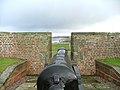 Fort George Cannon. - panoramio.jpg 2,816 × 2,120; 1.45 MB
-
 Fort George Church in the rain. - panoramio.jpg 2,816 × 2,120; 1.51 MB
-
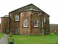 Fort George Church. - panoramio.jpg 2,048 × 1,536; 888 KB
-
 Fort George church. - panoramio.jpg 2,048 × 1,536; 824 KB
-
 Fort George I spent 3 years stationed there - panoramio.jpg 2,288 × 1,712; 733 KB
-
 Fort George Rainbow - panoramio.jpg 2,288 × 1,712; 717 KB
-
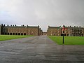 Fort George. - panoramio.jpg 2,288 × 1,712; 694 KB
-
 Free Range Cattle at Woolhouse Farm - geograph.org.uk - 264114.jpg 640 × 480; 154 KB
-
 Fuar Loch Mor - geograph.org.uk - 264386.jpg 640 × 482; 54 KB
-
 George and Dragon, Great Budworth.jpg 640 × 480; 157 KB
-
 Glasgow Cathedral - geograph.org.uk - 277899.jpg 378 × 640; 59 KB
-
 Glasgow High Court - geograph.org.uk - 277898.jpg 640 × 296; 39 KB
-
 Glasgow Royal Concert Hall 2.jpg 480 × 640; 59 KB
-
 Glen Clunie - geograph.org.uk - 531173.jpg 640 × 426; 58 KB
-
 Glen Clunie in autumn - geograph.org.uk - 531167.jpg 640 × 426; 59 KB
-
 Globe Hotel, Topsham - geograph.org.uk - 265794.jpg 640 × 528; 86 KB
-
 Gorse on Pound Common - geograph.org.uk - 264161.jpg 640 × 480; 184 KB
-
 Goscote Hospital - geograph.org.uk - 264042.jpg 600 × 450; 275 KB
-
 Grangegreen (farm) - geograph.org.uk - 264602.jpg 640 × 480; 193 KB
-
 Grangegreen entrance - geograph.org.uk - 264606.jpg 640 × 480; 181 KB
-
 Grapevines - geograph.org.uk - 265555.jpg 640 × 480; 145 KB
-
 Great Spelty Wood - geograph.org.uk - 266122.jpg 640 × 480; 70 KB
-
 Green - geograph.org.uk - 264545.jpg 640 × 456; 66 KB
-
 Freeman Street - geograph.org.uk - 313736.jpg 640 × 326; 108 KB
-
 The Angel Hotel - geograph.org.uk - 314500.jpg 640 × 450; 124 KB
-
 The Methodist Church, Wellington Street - geograph.org.uk - 314467.jpg 640 × 422; 103 KB
-
 The Wellington Arms - geograph.org.uk - 313729.jpg 640 × 348; 92 KB
-
 Grimsby Synagogue - geograph.org.uk - 264444.jpg 640 × 480; 113 KB
-
 Heneage Road School - geograph.org.uk - 264037.jpg 480 × 640; 167 KB
-
 Heneage Road School - geograph.org.uk - 264038.jpg 479 × 640; 132 KB
-
 Gt Budworth Post Office - geograph.org.uk - 267125.jpg 480 × 640; 147 KB
-

-
 Hale Purlieu - geograph.org.uk - 264368.jpg 640 × 480; 65 KB
-
 Hanley fire station - geograph.org.uk - 266823.jpg 640 × 427; 172 KB
-
 Hartley - geograph.org.uk - 270548.jpg 640 × 480; 107 KB
-
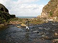 Heddon's Mouth - geograph.org.uk - 738451.jpg 640 × 480; 85 KB
-
 Heneage Road - geograph.org.uk - 264041.jpg 640 × 492; 171 KB
-
 Hereford Railway Station.jpg 640 × 480; 92 KB


_-_geograph.org.uk_-_265754.jpg)


_-_geograph.org.uk_-_264103.jpg)


.jpg)
.jpg)
.jpg)


_-_geograph.org.uk_-_264602.jpg)


