Category:United Kingdom photographs taken on 2007-01-22
Countries of Europe: Armenia‡ · Austria · Belgium · Bulgaria · Finland · France‡ · Germany · Republic of Ireland · Italy · Latvia · Netherlands‡ · Poland · Portugal‡ · Russia‡ · Serbia · Spain‡ · Sweden · Turkey‡ · United Kingdom
‡: partly located in Europe
‡: partly located in Europe
| ← | 22 January 2007 | → | ||
| ← | January 2007 | → | ||

United Kingdom photographs taken on 22 January 2007.
Image files should be categorized here automatically using {{taken on}} template. Direct categorisation is also possible, if automatic is impossible.
Subcategories
This category has only the following subcategory.
Media in category "United Kingdom photographs taken on 2007-01-22"
The following 200 files are in this category, out of 452 total.
(previous page) (next page)-
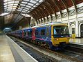
 166207 A London Paddington.JPG 2,048 × 1,536; 986 KB
-
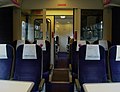
 166207 DMCO First Class Interior.JPG 1,971 × 1,488; 927 KB
-
 166207 DMCO Interior.JPG 2,015 × 1,517; 1.45 MB
-
 166218 London Paddington.JPG 2,048 × 1,536; 1.37 MB
-
 180108 A London Paddington.JPG 1,988 × 1,447; 1.34 MB
-
 180108 A M DMSO Interior 1.JPG 2,006 × 1,506; 872 KB
-
 180108 A M DMSO Interior 2.JPG 1,896 × 1,388; 927 KB
-
 180108 A MFO Interior.JPG 2,048 × 1,536; 926 KB
-
 180108 A MSO Interior.JPG 2,048 × 1,536; 942 KB
-
 180109 A London Paddington.JPG 1,930 × 1,494; 1.41 MB
-
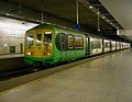 319011 B London St Pancras.JPG 1,983 × 1,535; 1.01 MB
-
 321415 DTCO First Class Interior.JPG 2,013 × 1,535; 1.22 MB
-
 321415 DTCO First Class Internal.JPG 2,015 × 1,535; 1.19 MB
-
 332005 RBS Advert First Class 1.JPG 1,927 × 1,365; 1.04 MB
-
 332007 A London Paddington.JPG 2,048 × 1,460; 1.22 MB
-
 332008 A First Class Interior.JPG 1,804 × 1,440; 768 KB
-
 332012 A London Paddington.JPG 1,921 × 1,273; 916 KB
-
 350115 x First Class Interior.JPG 2,010 × 1,496; 757 KB
-
 455740 D Wimbledon.JPG 1,973 × 1,465; 1.34 MB
-
 455857 D London Waterloo.JPG 1,597 × 1,507; 1.05 MB
-
 455905 455853 D London Waterloo.JPG 2,002 × 1,271; 2.43 MB
-
 A1 M18 Interchange - geograph.org.uk - 321784.jpg 640 × 480; 83 KB
-
 A22 Maresfield Bypass - geograph.org.uk - 318253.jpg 640 × 428; 78 KB
-
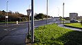
 A22-A272 (West) Roundabout - geograph.org.uk - 318269.jpg 640 × 429; 74 KB
-

-
 Access track to the Whirlaw Stones - geograph.org.uk - 322618.jpg 640 × 480; 147 KB
-
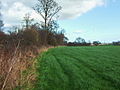
 Across the fields - geograph.org.uk - 319980.jpg 640 × 480; 118 KB
-
 Adam Smith College - geograph.org.uk - 319534.jpg 640 × 424; 51 KB
-
 Adam Smith Theatre - geograph.org.uk - 318642.jpg 640 × 424; 54 KB
-

-
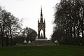 Albert Memorial - geograph.org.uk - 479172.jpg 640 × 426; 242 KB
-
 Alkmonton Old Hall Farm - geograph.org.uk - 318623.jpg 640 × 480; 57 KB
-
 Allington farm shop - geograph.org.uk - 318774.jpg 640 × 480; 59 KB
-
 Auchmannoch Crofthead road end - geograph.org.uk - 321847.jpg 640 × 426; 133 KB
-
 Auchmillan Land Use - geograph.org.uk - 321843.jpg 640 × 426; 58 KB
-
 Auchmillanhill Farm - geograph.org.uk - 321846.jpg 640 × 426; 64 KB
-
 Ayrshire Plain - geograph.org.uk - 322814.jpg 640 × 426; 50 KB
-
 Back Lane - geograph.org.uk - 319612.jpg 640 × 360; 80 KB
-
 Barn at Hunts Down - geograph.org.uk - 318329.jpg 640 × 480; 79 KB
-
 Barton Cottages - geograph.org.uk - 318353.jpg 640 × 480; 69 KB
-
 Barton Cottages - photoshopped 318353.jpg 535 × 385; 221 KB
-
 Bartonpark Farm - geograph.org.uk - 318607.jpg 640 × 480; 63 KB
-
 Beacon House, Hartlepool Headland - geograph.org.uk - 318318.jpg 640 × 480; 57 KB
-
 Becca Lodge - geograph.org.uk - 320719.jpg 640 × 480; 114 KB
-
 Belle Isle Park - geograph.org.uk - 320700.jpg 640 × 480; 78 KB
-
 Bent House - geograph.org.uk - 318349.jpg 640 × 480; 119 KB
-
 Blackdyke - geograph.org.uk - 322007.jpg 640 × 426; 76 KB
-
 Blackpark Moss - geograph.org.uk - 318350.jpg 600 × 401; 34 KB
-
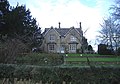
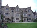 BolehydeManor.jpg 640 × 480; 72 KB
-
 Bracket Fungus at the Harewarren - geograph.org.uk - 318182.jpg 480 × 640; 142 KB
-
 Bride Stones - geograph.org.uk - 322910.jpg 640 × 480; 140 KB
-
-

-
 Bridleway from Hunts Down to Burcombe - geograph.org.uk - 318326.jpg 640 × 480; 97 KB
-

-

-
 Brook coming from Darwen Moor - geograph.org.uk - 318403.jpg 480 × 640; 114 KB
-
 Brookmount Road, Omagh - geograph.org.uk - 318866.jpg 640 × 479; 68 KB
-
 Brookmount Road, Omagh - geograph.org.uk - 318873.jpg 640 × 278; 28 KB
-
 Brookmount Road, Omagh - geograph.org.uk - 318875.jpg 640 × 351; 30 KB
-
 Broom Avenue - geograph.org.uk - 320676.jpg 640 × 360; 62 KB
-
 Brumber Hill Farm - geograph.org.uk - 320770.jpg 640 × 480; 75 KB
-
 Buildings at Hartlepool Historic Quay - geograph.org.uk - 318313.jpg 640 × 480; 65 KB
-
 Bull Ring at night - geograph.org.uk - 891436.jpg 640 × 480; 72 KB
-
 Bungalows - geograph.org.uk - 319703.jpg 640 × 360; 82 KB
-

-
 Caerloch Dhu - geograph.org.uk - 318981.jpg 640 × 480; 126 KB
-
 Cairn above Trevor - geograph.org.uk - 538352.jpg 640 × 480; 64 KB
-
 Catterton Beck from Catterton lane - geograph.org.uk - 320735.jpg 640 × 480; 160 KB
-
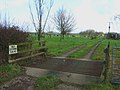 Cattle Grid - geograph.org.uk - 319988.jpg 640 × 480; 92 KB
-
 Cemex Works, Rugby.jpg 640 × 480; 129 KB
-
 Claypit Hill - geograph.org.uk - 318346.jpg 640 × 480; 117 KB
-
 Coastline at Balmae Ha'en - geograph.org.uk - 324172.jpg 640 × 427; 138 KB
-

-
 Converted Barn - geograph.org.uk - 319993.jpg 640 × 480; 115 KB
-
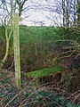
 Copse near the path - geograph.org.uk - 319281.jpg 640 × 480; 117 KB
-
 Cornfield - geograph.org.uk - 319878.jpg 640 × 480; 117 KB
-
 Cottages at Yatton Keynell - geograph.org.uk - 318730.jpg 565 × 418; 97 KB
-
 Council Offices - geograph.org.uk - 319444.jpg 640 × 424; 51 KB
-
 Country junction - geograph.org.uk - 318665.jpg 640 × 480; 171 KB
-
 Country Lane - geograph.org.uk - 318659.jpg 640 × 480; 171 KB
-
 Covert Farm - geograph.org.uk - 319886.jpg 640 × 480; 51 KB
-
 Crossroads at Broad Town - geograph.org.uk - 318008.jpg 640 × 480; 58 KB
-
 Crowfoot Farm - geograph.org.uk - 318589.jpg 640 × 480; 117 KB
-
 Cyclist and pedestrian by River Exe - geograph.org.uk - 320752.jpg 640 × 480; 80 KB
-
 Dairy Farm - geograph.org.uk - 327891.jpg 640 × 426; 79 KB
-
 Dairy House Farm - geograph.org.uk - 318614.jpg 640 × 480; 113 KB
-

-

-
 Disused Runway - geograph.org.uk - 319970.jpg 640 × 480; 119 KB
-
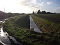 Drainage Ditch Near Gedney Drove End - geograph.org.uk - 318787.jpg 640 × 480; 107 KB
-
 Draycot Park - geograph.org.uk - 318373.jpg 634 × 461; 163 KB
-
 Duck Bay - geograph.org.uk - 393522.jpg 640 × 427; 59 KB
-
 Elm Row and Christ Church spire - geograph.org.uk - 321027.jpg 480 × 640; 113 KB
-
 Entrance drive, Sheldon Manor - geograph.org.uk - 318856.jpg 640 × 480; 132 KB
-
 Ewes and Lambs on Hunts Down - geograph.org.uk - 318330.jpg 640 × 480; 81 KB
-
 Exit from Leigh Delamere services - geograph.org.uk - 318789.jpg 640 × 480; 55 KB
-

-
 Farm track and footpath - geograph.org.uk - 318357.jpg 640 × 480; 118 KB
-
 Fen Drain, North Hykeham - geograph.org.uk - 318776.jpg 640 × 427; 75 KB
-
 Fen Lane - geograph.org.uk - 318778.jpg 640 × 427; 75 KB
-
 Fen Lane - geograph.org.uk - 318779.jpg 640 × 427; 80 KB
-
 Ffynnon Wen with a dusting of snow - geograph.org.uk - 318406.jpg 640 × 594; 124 KB
-
 FGW 43127 D London Paddington.JPG 2,017 × 1,355; 886 KB
-
 FGW Night Riviera Mark 3A SLEP 10594.JPG 1,989 × 1,392; 1.15 MB
-
 FGW Night Riviera Sleeper Mark 3A RFM 10225.JPG 2,048 × 1,536; 1.1 MB
-

-
 Field and pond - geograph.org.uk - 319266.jpg 640 × 480; 112 KB
-

-
 Field track and path - geograph.org.uk - 319985.jpg 640 × 480; 95 KB
-
 Field with mere - geograph.org.uk - 319983.jpg 640 × 480; 116 KB
-
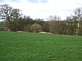
 Fields and woods - geograph.org.uk - 318672.jpg 640 × 480; 224 KB
-
 Fields Close to Holbeach Hurn - geograph.org.uk - 318805.jpg 640 × 480; 125 KB
-
 First Great Western Refreshed HST A3 TGS 44032 Interior.JPG 1,998 × 1,432; 1.09 MB
-
 Flailed Hedge - geograph.org.uk - 318685.jpg 640 × 427; 88 KB
-
 Flooded Meadows at Odstock - geograph.org.uk - 318381.jpg 640 × 480; 89 KB
-
 Foot of Bowling Alley, Rastrick - geograph.org.uk - 320863.jpg 480 × 640; 100 KB
-

-
 Footpath from Bent Lane. - geograph.org.uk - 319978.jpg 640 × 480; 117 KB
-
 Footpath off Toothill Bank, Rastrick - geograph.org.uk - 321479.jpg 640 × 498; 123 KB
-
 Footpath to Bungalow Farm - geograph.org.uk - 319997.jpg 640 × 480; 120 KB
-
 Footpath to Heathy Close - geograph.org.uk - 318362.jpg 640 × 480; 118 KB
-
 Footpath to North Greetwell - geograph.org.uk - 318727.jpg 640 × 427; 89 KB
-
 Gasometers across the Exe - geograph.org.uk - 320721.jpg 640 × 472; 64 KB
-

-
 Geographers^ at Pont Penllyn - geograph.org.uk - 318441.jpg 640 × 343; 73 KB
-
 Glaik Farm and Core Hill of Glaik - geograph.org.uk - 318351.jpg 600 × 401; 76 KB
-
 Glenalla - geograph.org.uk - 318773.jpg 640 × 480; 107 KB
-
 Gorse Flowers - geograph.org.uk - 319868.jpg 640 × 480; 88 KB
-
 Grassyards - geograph.org.uk - 322806.jpg 640 × 426; 47 KB
-
 Great Rock - geograph.org.uk - 322620.jpg 640 × 480; 113 KB
-
 Greater London House, Camden Town - geograph.org.uk - 319426.jpg 640 × 480; 108 KB
-
 Greetwell Lane - geograph.org.uk - 318687.jpg 640 × 427; 66 KB
-
 Greetwell Lane looking south - geograph.org.uk - 318690.jpg 640 × 427; 70 KB
-
 Westfield Drive - geograph.org.uk - 318724.jpg 640 × 427; 63 KB
-
 Guildhall St, Bury St Edmunds, Suffolk - geograph.org.uk - 357297.jpg 640 × 480; 105 KB
-

-
 Haha, off Huddersfield Road, Rastrick - geograph.org.uk - 320833.jpg 640 × 475; 162 KB
-
 Hampstead Square - geograph.org.uk - 324741.jpg 640 × 480; 113 KB
-
 Haylane Farm - geograph.org.uk - 318581.jpg 640 × 480; 64 KB
-

-
 Hedgeside Path - geograph.org.uk - 319873.jpg 640 × 480; 93 KB
-
 Hessle Haven - geograph.org.uk - 320731.jpg 640 × 480; 117 KB
-
 Hessle Railway Station 1.jpg 640 × 480; 126 KB
-
 Historic pic of Wythenshawe - late January 2007 - panoramio.jpg 2,048 × 1,536; 987 KB
-
 Holly Bank, Rastrick - geograph.org.uk - 320664.jpg 640 × 468; 112 KB
-

-
 House at Leigh Delamere - geograph.org.uk - 318394.jpg 625 × 439; 140 KB
-
 House off Huddersfield Road, Rastrick - geograph.org.uk - 321632.jpg 640 × 497; 152 KB
-

-
 Houses along Toothill Lane. Rastrick - geograph.org.uk - 321569.jpg 640 × 437; 60 KB
-
 Houses at Compton - geograph.org.uk - 319292.jpg 640 × 480; 118 KB
-
 Houses off Toothill Lane, Rastrick - geograph.org.uk - 321465.jpg 640 × 480; 113 KB
-

-

-
 Jetty, Hartlepool Headland - geograph.org.uk - 318319.jpg 640 × 480; 66 KB
-
 319011 B Nameplate.JPG 1,675 × 1,194; 559 KB
-
 Jumble Dyke, Rastrick - geograph.org.uk - 320667.jpg 640 × 482; 73 KB
-
 Kilfeaghan Dolmen - geograph.org.uk - 1096530.jpg 640 × 426; 77 KB
-
 Kirkcaldy - geograph.org.uk - 318620.jpg 640 × 424; 58 KB
-
 Kirkcaldy - geograph.org.uk - 318676.jpg 640 × 424; 47 KB
-
 Kirkcaldy - geograph.org.uk - 318760.jpg 640 × 424; 48 KB
-
 Kirkcaldy War Memorial - geograph.org.uk - 319496.jpg 640 × 424; 46 KB
-
 Kirkcaldy War Memorial - geograph.org.uk - 319504.jpg 640 × 424; 51 KB
-
 Kirkcudbright Lifeboat Station - geograph.org.uk - 324161.jpg 640 × 427; 61 KB
-
 Knowhead road junction - geograph.org.uk - 321982.jpg 640 × 426; 89 KB
-
 Lane near Piltdown Golf Club - geograph.org.uk - 318223.jpg 640 × 428; 152 KB
-
 Little used footpath - geograph.org.uk - 320001.jpg 480 × 640; 115 KB
-
 Livestock Farm - geograph.org.uk - 321819.jpg 640 × 426; 60 KB
-
 Livingstone Statue, Kensington - geograph.org.uk - 479173.jpg 640 × 426; 257 KB
-

-
 Londres - panoramio (1).jpg 1,280 × 960; 992 KB
-
 Long Ridge, Rastrick - geograph.org.uk - 321491.jpg 640 × 430; 68 KB
-
 Looking toward North Shian - geograph.org.uk - 500149.jpg 640 × 426; 53 KB
-
 Lough Skitter, Killybrack, Omagh - geograph.org.uk - 318901.jpg 640 × 215; 30 KB
-
 Lough Skitter, Killybrack, Omagh - geograph.org.uk - 318902.jpg 640 × 280; 38 KB
-
 Lough Skitter, Omagh - geograph.org.uk - 318893.jpg 640 × 295; 35 KB
-
 Lough Skitter, Omagh - geograph.org.uk - 318896.jpg 640 × 479; 68 KB
-
 Lyndhurst Avenue, Rastrick - geograph.org.uk - 321558.jpg 640 × 451; 74 KB
-
 M4 Motorway, looking west - geograph.org.uk - 318372.jpg 640 × 480; 53 KB
-
 Manor Farm - geograph.org.uk - 318738.jpg 640 × 427; 84 KB
-
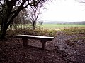 Memorial Seat at the Harewarren - geograph.org.uk - 318177.jpg 640 × 480; 130 KB
-
 Millennium Stone - geograph.org.uk - 318762.jpg 640 × 427; 83 KB
-
 Modernised Rural Dwelling House - geograph.org.uk - 321813.jpg 640 × 426; 67 KB
-
 MSC Napoli - geograph.org.uk - 318359.jpg 640 × 480; 64 KB
-
 National grid - geograph.org.uk - 318706.jpg 640 × 480; 92 KB
-
 New Bridleway - geograph.org.uk - 318601.jpg 640 × 480; 114 KB
-
 New farm near Birchills - geograph.org.uk - 319974.jpg 640 × 480; 119 KB
-
 New homes off Hawthorn Avenue - geograph.org.uk - 318713.jpg 640 × 427; 47 KB
-
 New housing off Fen Lane - geograph.org.uk - 318777.jpg 640 × 427; 70 KB
-
 Next year's fertiliser - geograph.org.uk - 319881.jpg 640 × 480; 71 KB
-

-
 No. 60, Southfield, Hessle - geograph.org.uk - 318484.jpg 640 × 480; 220 KB
-
 Old Runway - geograph.org.uk - 319965.jpg 640 × 480; 117 KB
-
 Omagh's main churches. - geograph.org.uk - 318887.jpg 640 × 479; 55 KB
-
 Orchard Road - geograph.org.uk - 318926.jpg 640 × 480; 79 KB
-
 Organic farm - geograph.org.uk - 318382.jpg 640 × 480; 92 KB
-
 Oxenshaw Farm - geograph.org.uk - 321829.jpg 640 × 426; 38 KB
-
 Oxenshaw Woodland - geograph.org.uk - 321993.jpg 640 × 426; 47 KB
-


_Roundabout_-_geograph.org.uk_-_318269.jpg)


_-_geograph.org.uk_-_646823.jpg)


.jpg)


