Category:United Kingdom photographs taken on 2007-03-15
Countries of Europe: Austria · Belarus · Belgium · France‡ · Germany · Hungary · Republic of Ireland · Italy · Malta · Netherlands‡ · Norway · Poland · Portugal‡ · Russia‡ · Slovakia · Spain‡ · Sweden · Switzerland · Turkey‡ · Ukraine · United Kingdom
‡: partly located in Europe
‡: partly located in Europe
| ← | 15 March 2007 | → | ||
| ← | March 2007 | → | ||

United Kingdom photographs taken on 15 March 2007.
Image files should be categorized here automatically using {{taken on}} template. Direct categorisation is also possible, if automatic is impossible.
Subcategories
This category has only the following subcategory.
S
Media in category "United Kingdom photographs taken on 2007-03-15"
The following 200 files are in this category, out of 517 total.
(previous page) (next page)-
 'Fairway Village', Normanton - geograph.org.uk - 366454.jpg 640 × 480; 66 KB
-
 'The Crown', Old Basing, Hampshire - geograph.org.uk - 367465.jpg 640 × 427; 101 KB
-
 A 'pont' at Pontdolgoch - geograph.org.uk - 379746.jpg 640 × 480; 86 KB
-
 A Lane and a Farm - geograph.org.uk - 368524.jpg 640 × 480; 108 KB
-
 A New Hedge - geograph.org.uk - 366746.jpg 640 × 480; 97 KB
-
 A@a from And. collection Bedford England" - panoramio.jpg 1,200 × 1,600; 532 KB
-
 Achneim Wood - geograph.org.uk - 372357.jpg 640 × 480; 118 KB
-
 Allotments, Barnfield Close, Swindon (2) - geograph.org.uk - 366719.jpg 640 × 480; 110 KB
-
 Allotments, Barnfield Close, Swindon - geograph.org.uk - 366716.jpg 640 × 480; 114 KB
-
 Ardnish - geograph.org.uk - 366625.jpg 640 × 425; 192 KB
-
 Avenue of Chestnuts - geograph.org.uk - 451659.jpg 640 × 427; 128 KB
-
 Back gardens of Smallridge - geograph.org.uk - 427203.jpg 640 × 480; 123 KB
-
 Banstead Heath at Hogden Bottom - geograph.org.uk - 370330.jpg 640 × 481; 94 KB
-
 Basing, Hampshire, Tithe Barn - geograph.org.uk - 1730293.jpg 3,456 × 2,304; 4.84 MB
-
 Bassett Cottage - geograph.org.uk - 367219.jpg 640 × 461; 93 KB
-
 Bassett Court - geograph.org.uk - 367220.jpg 640 × 480; 88 KB
-
 Beckford Bridge - from the river - geograph.org.uk - 427134.jpg 640 × 480; 143 KB
-
 Beckford Bridge - geograph.org.uk - 427130.jpg 640 × 480; 132 KB
-
 Belmont bus terminus, Surrey - geograph.org.uk - 366810.jpg 640 × 427; 95 KB
-
 Bench at Thistle Hill - geograph.org.uk - 369302.jpg 640 × 481; 130 KB
-
 Bike on a Lane - geograph.org.uk - 368620.jpg 640 × 480; 86 KB
-
 Blanchworth - geograph.org.uk - 367102.jpg 640 × 480; 86 KB
-
 BMX Downhill Course, Applegarth Field - geograph.org.uk - 366899.jpg 640 × 426; 102 KB
-

-
 Boston - panoramio (12).jpg 2,816 × 2,112; 2.44 MB
-
 Boston - panoramio (13).jpg 2,816 × 2,112; 2.76 MB
-
 Boston - panoramio (14).jpg 2,816 × 2,112; 2.65 MB
-
 Boston - panoramio (15).jpg 2,816 × 2,112; 2.65 MB
-
 Boston - panoramio (16).jpg 2,816 × 2,112; 2.62 MB
-
 Boston - panoramio (19).jpg 2,816 × 2,112; 2.15 MB
-
 Boston - panoramio (2).jpg 2,816 × 2,112; 2.49 MB
-
 Boston - panoramio (22).jpg 2,816 × 2,112; 2.69 MB
-
 Boston - panoramio (3).jpg 2,816 × 2,112; 1.69 MB
-
 Boston - panoramio (4).jpg 2,816 × 2,112; 2.41 MB
-
 Boston - panoramio (6).jpg 2,816 × 2,112; 2.86 MB
-
 Boston - panoramio (7).jpg 2,816 × 2,112; 2.3 MB
-
 Brackla Aerodrome perimeter track - geograph.org.uk - 372312.jpg 640 × 480; 88 KB
-
 Brickworks Chimney - geograph.org.uk - 366371.jpg 480 × 640; 72 KB
-
 Bridge over the Umborne Brook - geograph.org.uk - 427060.jpg 640 × 480; 128 KB
-
 Bridleway and Big Trees - geograph.org.uk - 368671.jpg 480 × 640; 92 KB
-
 Bridleway at Thistle Hill - geograph.org.uk - 369321.jpg 640 × 481; 135 KB
-
 Bridleway Junction On Walton Heath - geograph.org.uk - 369348.jpg 640 × 481; 117 KB
-
 Bridleway on the Buckland Hills - geograph.org.uk - 369579.jpg 640 × 481; 114 KB
-
-
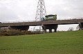
 Bristol to Gloucester train - geograph.org.uk - 367061.jpg 640 × 471; 105 KB
-
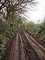
 Byway to Cleverhayes Farm - geograph.org.uk - 366531.jpg 640 × 480; 152 KB
-
 Caegoody - geograph.org.uk - 366753.jpg 640 × 480; 78 KB
-
 Cantray Bridge - geograph.org.uk - 372695.jpg 640 × 480; 182 KB
-
 Cantray Bridge Mill - geograph.org.uk - 372686.jpg 640 × 480; 145 KB
-
 Cardiff Bay - geograph.org.uk - 410365.jpg 640 × 480; 70 KB
-
 Carno Spar shop and Post Office - geograph.org.uk - 378536.jpg 640 × 480; 71 KB
-
 Carr Lane - geograph.org.uk - 370417.jpg 640 × 433; 99 KB
-
 Castle gate - geograph.org.uk - 372338.jpg 640 × 480; 106 KB
-
 Challenger Farm - geograph.org.uk - 427228.jpg 640 × 480; 100 KB
-
 Chantry House, North Nibley - geograph.org.uk - 367223.jpg 640 × 467; 78 KB
-
 Chisledon Hill, Higher Brixham - geograph.org.uk - 366676.jpg 480 × 640; 103 KB
-
 Church of St Cyr, Stinchcombe - geograph.org.uk - 367020.jpg 480 × 640; 89 KB
-
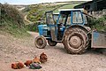
 Classic car at Grove farm - geograph.org.uk - 367450.jpg 640 × 480; 97 KB
-
 Cleave crossroads - geograph.org.uk - 424687.jpg 640 × 480; 108 KB
-
 Colnbrook Incinerator - geograph.org.uk - 366835.jpg 640 × 480; 117 KB
-
 Concrete ruins - geograph.org.uk - 372332.jpg 640 × 480; 59 KB
-
 Converted mill at Weycroft - geograph.org.uk - 427186.jpg 640 × 480; 105 KB
-
 Corner Lane - geograph.org.uk - 368660.jpg 640 × 480; 107 KB
-
 Corry Brook - geograph.org.uk - 427108.jpg 640 × 480; 125 KB
-
 St. Michael's church, Cotleigh - geograph.org.uk - 427050.jpg 640 × 480; 117 KB
-
 Cottage in Stinchcombe - geograph.org.uk - 367023.jpg 640 × 480; 91 KB
-
 Cottages at Commins Coch - geograph.org.uk - 373091.jpg 640 × 480; 78 KB
-
 Cottages on Cotleigh Road - geograph.org.uk - 424694.jpg 640 × 480; 84 KB
-
 Country lane in East Devon - geograph.org.uk - 424685.jpg 640 × 480; 120 KB
-

-
 Culbin Forest - geograph.org.uk - 373279.jpg 640 × 480; 78 KB
-
 Culbin Forest - geograph.org.uk - 373296.jpg 640 × 480; 94 KB
-
 Culbin Sands nature reserve - geograph.org.uk - 373248.jpg 640 × 480; 104 KB
-
 Daffodils and lorries at Pontdolgoch - geograph.org.uk - 379743.jpg 640 × 480; 71 KB
-
 Deep Slade from Pwlldu Head - geograph.org.uk - 461804.jpg 640 × 480; 126 KB
-
 Dew Pond - geograph.org.uk - 366750.jpg 640 × 480; 100 KB
-
 Dewsbury County Court.jpg 640 × 488; 91 KB
-
 Dewsbury station - geograph.org.uk - 367809.jpg 640 × 480; 99 KB
-
 Disused Ellesmere to Wrecsam Railway - geograph.org.uk - 366799.jpg 640 × 480; 134 KB
-
 Dol-fach village - geograph.org.uk - 378498.jpg 640 × 480; 119 KB
-
 Driveway to Wellands - geograph.org.uk - 427157.jpg 640 × 480; 97 KB
-
 Duck flighting pond at Caegoody - geograph.org.uk - 367181.jpg 640 × 480; 72 KB
-
 Duck pond and stables Buckland Farm - geograph.org.uk - 379196.jpg 640 × 480; 106 KB
-
 East Tuddenham Village sign - geograph.org.uk - 436442.jpg 480 × 640; 114 KB
-
 Easter Glackton Farm - geograph.org.uk - 372295.jpg 640 × 480; 56 KB
-
 Edgerton Moss from Grane Road - geograph.org.uk - 372224.jpg 640 × 480; 90 KB
-
 Eightlands housing estate, Dewsbury - geograph.org.uk - 367796.jpg 640 × 480; 70 KB
-
 Electricity Sub Station - geograph.org.uk - 366896.jpg 640 × 424; 62 KB
-
 Entrance Gates to Dawney Farm - geograph.org.uk - 366578.jpg 640 × 480; 119 KB
-
 Entrance to Southwold Pier - geograph.org.uk - 371276.jpg 640 × 516; 112 KB
-
 Entrance to Welbeck - geograph.org.uk - 366495.jpg 640 × 480; 62 KB
-
 Farm buildings by Chantry Wood - geograph.org.uk - 366535.jpg 640 × 480; 109 KB
-
 Farm cottages - geograph.org.uk - 366836.jpg 640 × 424; 52 KB
-
 Farm road and path to Stydd Hall - geograph.org.uk - 366627.jpg 640 × 480; 106 KB
-
 Farmland SE Of Burton Agnes - geograph.org.uk - 366548.jpg 640 × 480; 100 KB
-

-
 Feggy Coppice - geograph.org.uk - 366618.jpg 640 × 480; 63 KB
-
 Ferry Terminal - geograph.org.uk - 366397.jpg 640 × 480; 110 KB
-

-
 Fields South of Boville Park - geograph.org.uk - 366948.jpg 640 × 384; 55 KB
-
 Flash Lane - geograph.org.uk - 367568.jpg 640 × 480; 113 KB
-
 Footpath across a disused railway - geograph.org.uk - 366778.jpg 640 × 480; 142 KB
-
 Footpath through the farmyard - geograph.org.uk - 381115.jpg 640 × 480; 71 KB
-
 Footpath to Manor House Farm - geograph.org.uk - 381127.jpg 640 × 480; 111 KB
-
 Footpath towards Nantclimbers Wood - geograph.org.uk - 366759.jpg 640 × 480; 112 KB
-
 Fork in the road near Churchill, Devon - geograph.org.uk - 427211.jpg 640 × 480; 138 KB
-
 Fork right for Brinscombe Lane - geograph.org.uk - 427217.jpg 640 × 480; 132 KB
-
 Former harbourmaster's house, Bangor - geograph.org.uk - 366943.jpg 640 × 426; 136 KB
-
 Former wagon way - geograph.org.uk - 366934.jpg 640 × 424; 74 KB
-
 Foston A50 footbridge 368497 e61e7f86.jpg 640 × 480; 89 KB
-
 Foston Mill Farm - geograph.org.uk - 368501.jpg 640 × 480; 111 KB
-
 Freightliner - geograph.org.uk - 366390.jpg 640 × 480; 110 KB
-
 Frog Lane, North Nibley - geograph.org.uk - 367229.jpg 640 × 478; 75 KB
-
 Gabber Farm - geograph.org.uk - 418621.jpg 640 × 480; 83 KB
-
 Gable of Dewsbury station - geograph.org.uk - 367805.jpg 640 × 620; 84 KB
-
 Garth Avenue, Normanton - geograph.org.uk - 366438.jpg 640 × 480; 91 KB
-
 Gartly Moor Windfarm - geograph.org.uk - 415003.jpg 640 × 431; 96 KB
-
 Gate near Yards Lane, Brixham - geograph.org.uk - 366780.jpg 480 × 640; 102 KB
-
 Gateway to Eightlands Villa, Dewsbury - geograph.org.uk - 367779.jpg 640 × 480; 115 KB
-
 Georgian farmhouse north of Kilmington - geograph.org.uk - 427101.jpg 640 × 480; 112 KB
-
 Glen Etive Dusk - geograph.org.uk - 830695.jpg 640 × 480; 58 KB
-
 Gloucester to Bristol train - geograph.org.uk - 367408.jpg 640 × 480; 88 KB
-
 Godworthy Farm - geograph.org.uk - 366545.jpg 640 × 480; 68 KB
-
 Godworthy Moor - geograph.org.uk - 427291.jpg 640 × 480; 98 KB
-
 Goods line to Sharpness docks - geograph.org.uk - 367058.jpg 640 × 458; 91 KB
-
 Goosehill Junction Signal Box - geograph.org.uk - 366375.jpg 640 × 478; 128 KB
-
-
-
 Grazings near Gadlas - geograph.org.uk - 367163.jpg 640 × 480; 79 KB
-
 Great Batch - geograph.org.uk - 427275.jpg 640 × 480; 131 KB
-
 Greatwood Farm - geograph.org.uk - 366540.jpg 640 × 480; 62 KB
-
 Green Flag - Dawson's Corner - geograph.org.uk - 366684.jpg 638 × 405; 38 KB
-
 Green lane on Burgh Common, Attleborough - geograph.org.uk - 366603.jpg 640 × 424; 172 KB
-

-
 Hatson Pier - geograph.org.uk - 366381.jpg 640 × 480; 106 KB
-
 Hill Farm - geograph.org.uk - 366527.jpg 640 × 480; 116 KB
-
-
 Horsepool Street, Higher Brixham - geograph.org.uk - 366820.jpg 640 × 480; 69 KB
-
 Inchyettle Farm - geograph.org.uk - 372373.jpg 640 × 480; 108 KB
-
 Industry By Railway Line - geograph.org.uk - 367711.jpg 640 × 480; 91 KB
-
 Interior of Omagh Methodist Church - geograph.org.uk - 367168.jpg 640 × 480; 58 KB
-
 Isolated Barn - geograph.org.uk - 366630.jpg 640 × 480; 49 KB
-
 Jack and Jill Windmills - geograph.org.uk - 366558.jpg 640 × 480; 165 KB
-
 Jameson St, Hull - panoramio (1).jpg 917 × 1,200; 331 KB
-
 King's Moat, West Cowick - geograph.org.uk - 370416.jpg 640 × 427; 142 KB
-

-
 Kingston Drive, Normanton - geograph.org.uk - 366459.jpg 640 × 480; 94 KB
-

-
 Lane and stream - geograph.org.uk - 366544.jpg 480 × 640; 137 KB
-

-
 Lane snaking up the hill. - geograph.org.uk - 427285.jpg 640 × 480; 127 KB
-
 Lansallos, waterfall onto the beach - geograph.org.uk - 366822.jpg 480 × 640; 177 KB
-
 Laurel Cottage, Mogador - geograph.org.uk - 370157.jpg 640 × 481; 83 KB
-
 Lay-by on Normanton By-pass - geograph.org.uk - 366489.jpg 640 × 480; 67 KB
-
 Ladies Gym - Bradford Road - geograph.org.uk - 366707.jpg 636 × 439; 56 KB
-
 Olivet Chapel, Bradford Road, Leeds - geograph.org.uk - 366711.jpg 636 × 497; 58 KB
-
 Leigh House - Varley Street - geograph.org.uk - 366715.jpg 634 × 471; 63 KB
-
 Leigh House, Varley Street - geograph.org.uk - 366718.jpg 637 × 442; 59 KB
-
 Limestone Cliffs at Pwlldu Head - geograph.org.uk - 461811.jpg 640 × 480; 153 KB
-
 Limestone Cliffs at Southgate - geograph.org.uk - 461836.jpg 640 × 480; 138 KB
-
 Lincoln - panoramio (2).jpg 2,816 × 2,112; 2.52 MB
-
 Link road - geograph.org.uk - 366882.jpg 640 × 380; 50 KB
-
 Llanelli Masonic Hall - geograph.org.uk - 366920.jpg 640 × 480; 46 KB
-
 Local shops, Brinsham - geograph.org.uk - 367421.jpg 640 × 480; 58 KB
-
 Logging track in Jeremy's Wood - geograph.org.uk - 427081.jpg 640 × 480; 114 KB
-

-
 Los compañeros de Bagshot.JPG 1,024 × 768; 187 KB
-
 Lour Road, Forfar - geograph.org.uk - 654678.jpg 640 × 425; 86 KB
-
 M25 Eastwards at Mogador - geograph.org.uk - 369928.jpg 640 × 481; 71 KB
-
 M25 Motorway at Walton Heath - geograph.org.uk - 369528.jpg 640 × 481; 63 KB
-
 M25 Westwards at Mogador - geograph.org.uk - 369828.jpg 640 × 481; 69 KB
-
 M5 motorway, near Stinchcombe - geograph.org.uk - 367031.jpg 640 × 480; 64 KB
-
 M5 motorway, near Stinchcombe - geograph.org.uk - 367035.jpg 640 × 480; 53 KB
-
 M90 Motorway - geograph.org.uk - 366915.jpg 640 × 457; 49 KB
-
 Mappowder Church - geograph.org.uk - 367095.jpg 640 × 480; 201 KB
-
 Margery Grove at the Bridleway Crossing - geograph.org.uk - 370169.jpg 640 × 481; 108 KB
-
 Meandering farm road - geograph.org.uk - 373235.jpg 640 × 480; 126 KB
-
 Millgreen Farm - geograph.org.uk - 427111.jpg 640 × 480; 84 KB
-
 Miniature horses, Old Basing, Hampshire - geograph.org.uk - 367065.jpg 640 × 427; 144 KB
-
 Miscanthus - geograph.org.uk - 372244.jpg 640 × 480; 109 KB
-
 Molland, above the village - geograph.org.uk - 366789.jpg 640 × 427; 158 KB
-
 Molland, cottages near Great Champson - geograph.org.uk - 366767.jpg 640 × 427; 222 KB
-
 Molland, hedging - geograph.org.uk - 366770.jpg 640 × 427; 224 KB
-
 Molland, lane to Twitchen - geograph.org.uk - 366798.jpg 640 × 427; 194 KB
-
 Molland, Lower Hill - geograph.org.uk - 366775.jpg 640 × 427; 156 KB
-
 Molland, Luckworthy - geograph.org.uk - 366787.jpg 640 × 427; 180 KB
-
 Molland, Sheepwash - geograph.org.uk - 366774.jpg 640 × 427; 187 KB
-
 Molland, Smallacombe - geograph.org.uk - 366785.jpg 640 × 427; 224 KB
-
 Molland, towards West Molland Barton - geograph.org.uk - 366781.jpg 640 × 427; 171 KB
-
 Molland, West Molland Barton - geograph.org.uk - 366794.jpg 640 × 427; 169 KB
-
 Motorway - geograph.org.uk - 366862.jpg 640 × 424; 43 KB
-
-
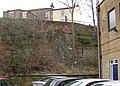 Mystery arch off Halifax Road, Dewsbury - geograph.org.uk - 367832.jpg 640 × 460; 111 KB
-
 New Pudsey Railway Station - geograph.org.uk - 366686.jpg 634 × 469; 71 KB
-
 Newland Surgery - geograph.org.uk - 366364.jpg 640 × 480; 68 KB
-
 Newlands of Little Urchany - geograph.org.uk - 372346.jpg 640 × 480; 98 KB
-
 Norleigh - geograph.org.uk - 372264.jpg 640 × 480; 55 KB
-
 North shore of Rubha Ardnish - geograph.org.uk - 366642.jpg 640 × 426; 121 KB
-
 Oddfellows Hall - Richardshaw Lane - geograph.org.uk - 366722.jpg 635 × 421; 57 KB
-
 Old houses, Milton Street, Brixham - geograph.org.uk - 366641.jpg 640 × 480; 80 KB


_-_geograph.org.uk_-_366719.jpg)


.jpg)
.jpg)
.jpg)
.jpg)
.jpg)
.jpg)
.jpg)
.jpg)
.jpg)
.jpg)
.jpg)
.jpg)


.jpg)


.jpg)


