Category:United Kingdom photographs taken on 2007-03-17
| ← | Saturday 17 March 2007 | → | ||
| ← | March 2007 | → | ||

United Kingdom photographs taken on 17 March 2007.
Image files should be categorized here automatically using {{taken on}} template. Direct categorisation is also possible, if automatic is impossible.
Subcategories
This category has the following 2 subcategories, out of 2 total.
L
S
Media in category "United Kingdom photographs taken on 2007-03-17"
The following 200 files are in this category, out of 1,063 total.
(previous page) (next page)-
 "Right of Way" West of Monkwood - geograph.org.uk - 368713.jpg 640 × 480; 189 KB
-
 "The Drive" - geograph.org.uk - 1203161.jpg 640 × 480; 125 KB
-
 'The Doors' - geograph.org.uk - 371290.jpg 480 × 640; 125 KB
-

-
 A Bridleway To Healaugh - geograph.org.uk - 369128.jpg 640 × 480; 103 KB
-
 A Bridleway To Healaugh - geograph.org.uk - 369134.jpg 640 × 480; 67 KB
-
 A Cow Barn At Healaugh Manor Farm - geograph.org.uk - 369139.jpg 640 × 480; 80 KB
-
 A Crossley oil engine - geograph.org.uk - 1574124.jpg 640 × 484; 72 KB
-
 A Field Of Rape - geograph.org.uk - 369124.jpg 640 × 480; 77 KB
-
 A Field Of Rape - geograph.org.uk - 369145.jpg 640 × 480; 101 KB
-

-
 A Ploughed Field - geograph.org.uk - 369126.jpg 640 × 480; 109 KB
-
 A slipway at Porth-y-wrach - geograph.org.uk - 369122.jpg 640 × 444; 67 KB
-
 A38 northbound - geograph.org.uk - 370941.jpg 640 × 480; 87 KB
-
 A38 southbound - geograph.org.uk - 370937.jpg 640 × 480; 75 KB
-
 Ackton Estate near Featherstone - geograph.org.uk - 368612.jpg 640 × 480; 64 KB
-
 Across the ploughed fields - geograph.org.uk - 380322.jpg 600 × 450; 197 KB
-
 Adnams Brewery, Southwold - geograph.org.uk - 371295.jpg 640 × 480; 88 KB
-
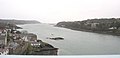
 Afon Menai east of Pont y Borth - geograph.org.uk - 369013.jpg 640 × 480; 39 KB
-
 Afon Menai from Pont y Borth - geograph.org.uk - 369260.jpg 640 × 309; 37 KB
-
 Akam House - geograph.org.uk - 372442.jpg 478 × 640; 87 KB
-

-
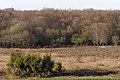 Alder carr at Matley Bog, New Forest - geograph.org.uk - 369897.jpg 640 × 427; 90 KB
-
 Alexanders at Gelliswick Bay - geograph.org.uk - 369714.jpg 640 × 480; 145 KB
-
 All dressed up... - geograph.org.uk - 394254.jpg 640 × 506; 117 KB
-

-
 All Saints' Church - geograph.org.uk - 377908.jpg 600 × 450; 86 KB
-
 Allt na Glaic Moire, Borrodale - geograph.org.uk - 369893.jpg 640 × 480; 155 KB
-
 Alnwick Town Hall - geograph.org.uk - 368756.jpg 480 × 640; 93 KB
-

-
 Approach to Welford Lock. - geograph.org.uk - 368367.jpg 640 × 480; 140 KB
-
 Approaching Bystaple Lane Level Crossing - geograph.org.uk - 369902.jpg 640 × 480; 116 KB
-

-
 Apsley House, 73 Wellington Street - geograph.org.uk - 368453.jpg 640 × 505; 91 KB
-
 Art work at Dysart harbour - geograph.org.uk - 1381503.jpg 640 × 400; 92 KB
-
 Ashford, Kent - geograph.org.uk - 1158633.jpg 640 × 480; 96 KB
-
 Auchorrie Burn - geograph.org.uk - 368300.jpg 480 × 640; 144 KB
-
 Barns - geograph.org.uk - 370317.jpg 640 × 480; 59 KB
-
 Barton Abbey1.jpg 640 × 480; 127 KB
-
 Barton Abbey2.jpg 640 × 480; 142 KB
-
 Bay of Biscay - geograph.org.uk - 371831.jpg 640 × 463; 83 KB
-
 Beach at Ardnambuth - geograph.org.uk - 369913.jpg 640 × 480; 94 KB
-
 Beech Tree above Greenway House - geograph.org.uk - 369240.jpg 640 × 480; 114 KB
-
 Beehives, Galmpton Crrek - geograph.org.uk - 368811.jpg 480 × 640; 98 KB
-
 Belgian obelisk - geograph.org.uk - 370637.jpg 640 × 370; 56 KB
-
 Benbow's greengrocers, Holt - geograph.org.uk - 805263.jpg 427 × 640; 255 KB
-

-

-
 Black Sike - geograph.org.uk - 367977.jpg 640 × 480; 92 KB
-
 Boat at Greenway Quay - geograph.org.uk - 369456.jpg 480 × 640; 114 KB
-
 Boats at Greenway Quay - geograph.org.uk - 369378.jpg 640 × 480; 80 KB
-

-
 Boundary dry stone wall - geograph.org.uk - 368549.jpg 480 × 640; 125 KB
-
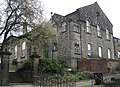
 Bradford Royal Infirmary - geograph.org.uk - 372440.jpg 640 × 477; 111 KB
-
 Brent Geese (Branta bernicla) - geograph.org.uk - 371104.jpg 640 × 480; 85 KB
-
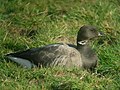 Brent Goose (Branta bernicla) - geograph.org.uk - 371075.jpg 640 × 480; 77 KB
-
 Bridge at canal junction - geograph.org.uk - 368424.jpg 640 × 480; 135 KB
-
 Bridge over disused railway at Ottinge - geograph.org.uk - 368791.jpg 640 × 480; 127 KB
-
 Bridge over Lettie River on the A839 - geograph.org.uk - 368450.jpg 640 × 480; 107 KB
-

-
 Bridge over River Fleet - geograph.org.uk - 368587.jpg 640 × 480; 84 KB
-
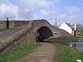
 Bridge Over the Canal - geograph.org.uk - 368908.jpg 640 × 314; 52 KB
-

-
 Bridle Path - geograph.org.uk - 368595.jpg 480 × 640; 70 KB
-
 Brim Hill, Galmpton Creek - geograph.org.uk - 368828.jpg 640 × 480; 63 KB
-

-
 Britannia Inn - geograph.org.uk - 369020.jpg 640 × 480; 61 KB
-
 Broken Wall, Grange Fell - geograph.org.uk - 370617.jpg 426 × 640; 118 KB
-
 Bryn y Wyntyll - geograph.org.uk - 413452.jpg 640 × 480; 73 KB
-
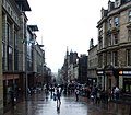 Buchanan Street - geograph.org.uk - 368990.jpg 640 × 560; 93 KB
-

-
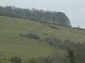
 Busy Sheep - geograph.org.uk - 369241.jpg 640 × 480; 77 KB
-
 Bwlch-y-sarnau - geograph.org.uk - 413457.jpg 640 × 480; 74 KB
-
 By Woodside Farm - geograph.org.uk - 368838.jpg 640 × 480; 121 KB
-
 Bystaple Lane Level Crossing - geograph.org.uk - 368522.jpg 640 × 386; 104 KB
-
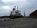 Canada Branch Dock(No.3) - geograph.org.uk - 368988.jpg 640 × 480; 45 KB
-
 Car park, Stiffkey Marshes - geograph.org.uk - 804904.jpg 640 × 427; 232 KB
-
 Carhampton - Sea Lane Crossing - geograph.org.uk - 372159.jpg 640 × 427; 153 KB
-
 Carn y Defaid - geograph.org.uk - 368514.jpg 640 × 480; 129 KB
-

-
 Carpark artwork - geograph.org.uk - 369324.jpg 640 × 480; 92 KB
-
 Carsgailoch Hill - Trig Pillar S5409 - geograph.org.uk - 851393.jpg 640 × 480; 47 KB
-
 Castle Crag - geograph.org.uk - 371149.jpg 640 × 426; 101 KB
-
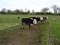 Cattle - geograph.org.uk - 374947.jpg 640 × 480; 102 KB
-
 Cellws barn - geograph.org.uk - 413598.jpg 640 × 480; 86 KB
-
 Chalk Quarry near Monkwood - geograph.org.uk - 368774.jpg 640 × 480; 141 KB
-
 Chartley Castle's Towers - geograph.org.uk - 368183.jpg 640 × 480; 113 KB
-
 Chartley viewed from through the trees - geograph.org.uk - 368192.jpg 640 × 480; 161 KB
-
 Chellow Dean Reservoir - geograph.org.uk - 371863.jpg 480 × 640; 142 KB
-
 Cherry Valley - geograph.org.uk - 373257.jpg 640 × 480; 187 KB
-
 Chimney, Lower Greenway - geograph.org.uk - 369166.jpg 640 × 480; 58 KB
-
 Church of St Maurice, Eglingham - geograph.org.uk - 368664.jpg 480 × 640; 106 KB
-
 Church Street, Grimsby - geograph.org.uk - 369984.jpg 640 × 420; 100 KB
-
 Claremont - New Street, Farsley - geograph.org.uk - 369115.jpg 637 × 334; 49 KB
-
 Clever Sheep - geograph.org.uk - 369252.jpg 640 × 480; 67 KB
-
 Close up of the Crossley oil engine - geograph.org.uk - 1574101.jpg 640 × 484; 78 KB
-
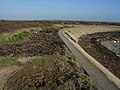
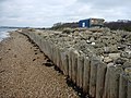 Coastal defence - geograph.org.uk - 370289.jpg 640 × 480; 88 KB
-
 Coastal defence 2 - geograph.org.uk - 370292.jpg 640 × 480; 104 KB
-
 Coastal defence 3 - geograph.org.uk - 370295.jpg 640 × 480; 116 KB
-
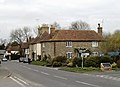
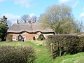 Common Cottages, Colemore Common - geograph.org.uk - 368590.jpg 640 × 480; 145 KB
-
 Thatched Cottages, Colemore Common - geograph.org.uk - 368853.jpg 640 × 480; 142 KB
-
 Collapsed bridge over the river Leadon - geograph.org.uk - 368857.jpg 640 × 426; 148 KB
-
 Common Side Farm - geograph.org.uk - 368644.jpg 640 × 480; 92 KB
-
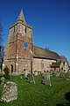
 St Peter church, Conisholme - geograph.org.uk - 372174.jpg 640 × 638; 583 KB
-
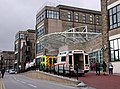
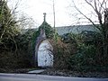
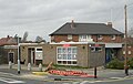
 Converted police box - geograph.org.uk - 368963.jpg 480 × 640; 113 KB
-
 Cooklands Farm - geograph.org.uk - 368663.jpg 640 × 480; 75 KB
-
 Cookridge Street - geograph.org.uk - 368441.jpg 457 × 633; 50 KB
-
 Coppenhall Church - geograph.org.uk - 368417.jpg 574 × 640; 43 KB
-
 Country lane - geograph.org.uk - 406561.jpg 640 × 480; 89 KB
-
 Country road - geograph.org.uk - 407726.jpg 640 × 480; 96 KB
-
 Course of River Thrushel - geograph.org.uk - 368996.jpg 640 × 480; 111 KB
-
 Creek, Stiffkey Marshes - geograph.org.uk - 804907.jpg 640 × 427; 217 KB
-

-
 Crowfield - geograph.org.uk - 370064.jpg 640 × 426; 118 KB
-
 Cuddy Ducks - Amble Harbour - geograph.org.uk - 368799.jpg 640 × 480; 92 KB
-
 Cwm Craf, Blorenge - geograph.org.uk - 368718.jpg 640 × 480; 150 KB
-
 Daffodil lane near Garth Fawr farm - geograph.org.uk - 405572.jpg 640 × 480; 78 KB
-
 Daffodils outside Dymock churchyard - geograph.org.uk - 370042.jpg 640 × 426; 135 KB
-
 Dale Head - geograph.org.uk - 367952.jpg 640 × 480; 113 KB
-
 Dartside Quay, Galmpton Creek - geograph.org.uk - 368685.jpg 640 × 480; 98 KB
-
 Dartside Quay, Galmpton Creek - geograph.org.uk - 368701.jpg 640 × 480; 77 KB
-

-

-
 Dinah Hoggus Camping Barn - geograph.org.uk - 370603.jpg 640 × 426; 72 KB
-
 Discussing tactics, Omagh - geograph.org.uk - 368226.jpg 640 × 479; 76 KB
-

-

-
 Dittisham and pier from Greenway Quay - geograph.org.uk - 369403.jpg 640 × 480; 56 KB
-
 Dittisham from Greenway Road - geograph.org.uk - 369270.jpg 640 × 468; 118 KB
-
 Dittisham from Greenway Road - geograph.org.uk - 369287.jpg 640 × 480; 147 KB
-
 Dittisham Pier, fron Greenway Quay - geograph.org.uk - 369424.jpg 640 × 480; 55 KB
-
 Downland near Ottinge - geograph.org.uk - 368808.jpg 640 × 475; 53 KB
-
 Downland Sheep - geograph.org.uk - 369219.jpg 640 × 480; 42 KB
-
 Dramatic entry - geograph.org.uk - 373321.jpg 640 × 480; 178 KB
-
 Driveway to New Buildings Farm - geograph.org.uk - 380314.jpg 600 × 450; 232 KB
-
 Driveway, Barton Lodge - geograph.org.uk - 370362.jpg 480 × 640; 191 KB
-
 Dry dock - geograph.org.uk - 370622.jpg 640 × 480; 99 KB
-
 Dry Stone Wall - geograph.org.uk - 369439.jpg 640 × 480; 151 KB
-
 Duck pond - geograph.org.uk - 407709.jpg 640 × 480; 77 KB
-
 Sundial, Dymock church - geograph.org.uk - 370013.jpg 640 × 426; 126 KB
-
 Dymock church - geograph.org.uk - 369995.jpg 426 × 640; 107 KB
-
 Dymock church and War Memorial - geograph.org.uk - 370028.jpg 640 × 426; 134 KB
-
 Dymock Cricket Club - geograph.org.uk - 370056.jpg 640 × 426; 125 KB
-
 East Ravendale School - geograph.org.uk - 372030.jpg 640 × 426; 354 KB
-
 Electricity Sub Station - geograph.org.uk - 368652.jpg 480 × 640; 72 KB
-
 Elham Valley Way near North Lyminge - geograph.org.uk - 368745.jpg 640 × 436; 58 KB
-
-

-
 Eroding coastline - geograph.org.uk - 370281.jpg 640 × 480; 70 KB
-
 Etchinghill - geograph.org.uk - 368602.jpg 640 × 462; 70 KB
-
 Eyarth railway no more - geograph.org.uk - 369423.jpg 640 × 480; 174 KB
-
 Eyarth Station - geograph.org.uk - 369404.jpg 640 × 426; 81 KB
-
 Fairway by the sea - geograph.org.uk - 370150.jpg 640 × 480; 55 KB
-
 Farlington Seawall - geograph.org.uk - 371097.jpg 640 × 480; 82 KB
-
 Farm by West End Lane, Horsforth - geograph.org.uk - 369436.jpg 640 × 480; 74 KB
-

-
 Farm gate, Hook Bottom, Greenway Road - geograph.org.uk - 368889.jpg 640 × 480; 105 KB
-
 Farm off Greenway, Stiffkey - geograph.org.uk - 804902.jpg 640 × 427; 221 KB
-
 Farm off Greenway, Stiffkey - geograph.org.uk - 804903.jpg 640 × 427; 175 KB
-
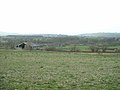
 Farmland at Pant-y-dwr - geograph.org.uk - 409355.jpg 640 × 480; 79 KB
-
 Farmland in the Afon Dulas valley - geograph.org.uk - 405564.jpg 640 × 480; 80 KB
-
 Farmland near Old Mill Cottage - geograph.org.uk - 413593.jpg 640 × 480; 72 KB
-

-
 Farsley Community Church - Back Lane - geograph.org.uk - 369092.jpg 638 × 461; 83 KB
-

-
 Farsley Liberal Club - Town Street - geograph.org.uk - 369100.jpg 636 × 540; 87 KB
-
 Farsley Library - Old Road - geograph.org.uk - 369101.jpg 636 × 404; 43 KB
-
 Fence, Galmpton Creek - geograph.org.uk - 368807.jpg 640 × 480; 117 KB
-
 Fence, Winfold Fell - geograph.org.uk - 368278.jpg 640 × 480; 87 KB
-
 Fenced off vegetation - geograph.org.uk - 1040573.jpg 640 × 480; 158 KB
-

-
 Ferry loading, Greenway Quay - geograph.org.uk - 369293.jpg 640 × 480; 64 KB
-

-
 Field slopes down sharply to Galmpton - geograph.org.uk - 368850.jpg 640 × 480; 80 KB
-

-
 Fields beside the A30 - geograph.org.uk - 368915.jpg 640 × 480; 99 KB
-

-
 Fire Plaque - Southwold - geograph.org.uk - 372031.jpg 640 × 480; 162 KB
-
 Fishing boat - geograph.org.uk - 371196.jpg 480 × 640; 92 KB
-
 Flavel Chapel Hall, Galmpton - geograph.org.uk - 368558.jpg 640 × 459; 70 KB
-
 Flavel Chapel, Galmpton - geograph.org.uk - 368589.jpg 640 × 480; 92 KB
-
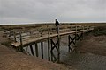 Footbridge, Stiffkey Marshes - geograph.org.uk - 804906.jpg 640 × 427; 207 KB
-

-
 Footpath up to field, Galmpton Creek - geograph.org.uk - 368746.jpg 480 × 640; 107 KB
-
 Footpath, Coombe Lane, near Galmpton - geograph.org.uk - 368460.jpg 640 × 480; 98 KB
-
 Ford on Hordron Road - geograph.org.uk - 368230.jpg 640 × 480; 135 KB
-
 Fordson tractor - geograph.org.uk - 371124.jpg 640 × 426; 139 KB
-

-
 Former chapel, Etchinghill.jpg 577 × 640; 50 KB
-
 From the Bridlepath - geograph.org.uk - 373267.jpg 640 × 480; 135 KB
-
 Galmpton Creek - geograph.org.uk - 368720.jpg 640 × 480; 137 KB
-
 Galmpton Creek - geograph.org.uk - 368738.jpg 640 × 474; 74 KB
-
 Galmpton Creek and Brim Hill - geograph.org.uk - 368760.jpg 640 × 480; 85 KB
-
 Galmpton Creek and Brim Hill - geograph.org.uk - 368789.jpg 640 × 480; 73 KB
-

-
-

-

-
 Gelliswick Bay oil pipeline and jetty - geograph.org.uk - 369636.jpg 640 × 404; 58 KB
-
 Glasgow city model - geograph.org.uk - 368984.jpg 640 × 392; 84 KB


_-_geograph.org.uk_-_371104.jpg)
_-_geograph.org.uk_-_371075.jpg)


_-_geograph.org.uk_-_368988.jpg)


