Category:United Kingdom photographs taken on 2007-04-04
Countries of Europe: Austria · Croatia · Czech Republic · Finland · France‡ · Germany · Greece · Hungary · Republic of Ireland · Italy · Latvia · Malta · Netherlands‡ · Norway · Poland · Portugal‡ · Russia‡ · Spain‡ · Sweden · Switzerland · Ukraine · United Kingdom
‡: partly located in Europe
‡: partly located in Europe
| ← | 4 April 2007 | → | ||
| ← | April 2007 | → | ||

United Kingdom photographs taken on 4 April 2007.
Image files should be categorized here automatically using {{taken on}} template. Direct categorisation is also possible, if automatic is impossible.
Subcategories
This category has the following 2 subcategories, out of 2 total.
S
Media in category "United Kingdom photographs taken on 2007-04-04"
The following 200 files are in this category, out of 1,231 total.
(previous page) (next page)-
 'Greener ' grass - geograph.org.uk - 398535.jpg 640 × 378; 245 KB
-
 'The Tally-Ho' inn, on the B1368 - geograph.org.uk - 388464.jpg 640 × 433; 66 KB
-
 (And another) boggy bit - geograph.org.uk - 392366.jpg 640 × 480; 112 KB
-
 (Another) boggy bit - geograph.org.uk - 391125.jpg 640 × 480; 121 KB
-
 1st Bilston Scouts - geograph.org.uk - 387773.jpg 640 × 480; 148 KB
-
 A contradiction in terms^ - geograph.org.uk - 527952.jpg 640 × 480; 118 KB
-

-
 A dead Tree - geograph.org.uk - 388157.jpg 372 × 640; 55 KB
-
 A lion on the footpath - geograph.org.uk - 439221.jpg 640 × 482; 187 KB
-
 A mother's predicament - geograph.org.uk - 389851.jpg 640 × 480; 82 KB
-

-
 A Tree near The Lea - geograph.org.uk - 388185.jpg 640 × 430; 81 KB
-
 A631 entering Tickhill. - geograph.org.uk - 388436.jpg 640 × 427; 122 KB
-
 A647 Stanningley Bypass - geograph.org.uk - 387866.jpg 416 × 622; 46 KB
-
 Abbey Walk, Halifax - geograph.org.uk - 391240.jpg 640 × 522; 137 KB
-
 Abbot's Tower - geograph.org.uk - 397766.jpg 640 × 480; 125 KB
-
 Above Sevensprings Cleugh - geograph.org.uk - 392381.jpg 640 × 480; 127 KB
-
 Access to South Newfield - geograph.org.uk - 387938.jpg 640 × 480; 85 KB
-
 Access to the industrial estate - geograph.org.uk - 387886.jpg 600 × 450; 190 KB
-
-
 Acton Moor - geograph.org.uk - 389672.jpg 640 × 480; 126 KB
-
 Agricultural and military - geograph.org.uk - 395612.jpg 640 × 480; 87 KB
-

-
 All Saints church - mermaid bench end - geograph.org.uk - 1555150.jpg 480 × 640; 159 KB
-
 All Saints church - rood screen - geograph.org.uk - 1555139.jpg 640 × 480; 138 KB
-
 Allendale Golf Club - geograph.org.uk - 391003.jpg 640 × 480; 87 KB
-
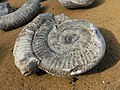 Ammonite at Port Mulgrave - geograph.org.uk - 397800.jpg 640 × 480; 131 KB
-
 An t-Aigeach - geograph.org.uk - 511653.jpg 640 × 320; 130 KB
-
 Ancient stone bridge - geograph.org.uk - 390479.jpg 640 × 480; 58 KB
-
 Ancient stone bridge - geograph.org.uk - 390482.jpg 640 × 480; 58 KB
-
 Anyone for ice-cream^ - geograph.org.uk - 776028.jpg 640 × 424; 57 KB
-
 Approach towards Raemoir - geograph.org.uk - 388001.jpg 640 × 480; 66 KB
-
 Aram Grange - geograph.org.uk - 390212.jpg 640 × 480; 83 KB
-
 Arbroath Clifftop Walk - geograph.org.uk - 648064.jpg 640 × 425; 97 KB
-

-
 St Saviours in Auckley - geograph.org.uk - 391233.jpg 640 × 480; 122 KB
-
 Aviarys At East Park Hull.jpg 480 × 640; 93 KB
-
 Ba Bridge - geograph.org.uk - 397356.jpg 640 × 620; 142 KB
-
 Babell Chapel - geograph.org.uk - 388351.jpg 640 × 480; 72 KB
-
 Back road to Sinderhope - geograph.org.uk - 389218.jpg 640 × 480; 82 KB
-
 Bales and Common - geograph.org.uk - 391239.jpg 640 × 480; 113 KB
-
 Ballykelly Clinic - geograph.org.uk - 388558.jpg 640 × 480; 150 KB
-
 Ballykelly forest - geograph.org.uk - 388567.jpg 640 × 480; 196 KB
-
 Ballykelly village.jpg 640 × 480; 153 KB
-
 Band Stand - Lister Park - geograph.org.uk - 387975.jpg 637 × 402; 39 KB
-
 Bank of a reservoir - geograph.org.uk - 507388.jpg 640 × 480; 88 KB
-
 Barbeth - geograph.org.uk - 397674.jpg 640 × 480; 116 KB
-
 Bardonside - geograph.org.uk - 388123.jpg 640 × 367; 214 KB
-
 Barrowsland Farm from Reading Sewer - geograph.org.uk - 388781.jpg 640 × 479; 152 KB
-
 Barton Bendish.jpg 640 × 480; 94 KB
-
 Reedbed with Swan - geograph.org.uk - 387896.jpg 640 × 426; 146 KB
-
 Batteries on Lingham Lane - geograph.org.uk - 391809.jpg 640 × 480; 91 KB
-
 Beach at Needs Ore Point - geograph.org.uk - 392231.jpg 640 × 480; 102 KB
-
-
 Beachamwell post office - geograph.org.uk - 507332.jpg 640 × 480; 96 KB
-
 Beacon Point - geograph.org.uk - 510484.jpg 443 × 640; 69 KB
-
 Beech and birch - geograph.org.uk - 397425.jpg 640 × 480; 143 KB
-
 Beech and conifer - geograph.org.uk - 527996.jpg 640 × 480; 165 KB
-
 Beech bark - geograph.org.uk - 527958.jpg 522 × 640; 181 KB
-
 Beech trees - early spring - geograph.org.uk - 527898.jpg 640 × 480; 153 KB
-
 Beech Wood - geograph.org.uk - 397372.jpg 640 × 480; 98 KB
-

-
 Bennetts Road Allotments - geograph.org.uk - 388105.jpg 640 × 480; 117 KB
-
 Bennetts Road Allotments - geograph.org.uk - 388121.jpg 640 × 480; 98 KB
-
 Bentley Manor - geograph.org.uk - 387908.jpg 640 × 480; 122 KB
-
 Bethel Chapel - geograph.org.uk - 407628.jpg 640 × 480; 77 KB
-
 St Oswald's Church, Bidston.jpg 640 × 480; 79 KB
-

-
 Black Water, Needs Ore Marshes - geograph.org.uk - 389756.jpg 640 × 480; 104 KB
-

-
-

-
 Bolam Lake - geograph.org.uk - 387863.jpg 427 × 640; 157 KB
-
 Booth Dean - geograph.org.uk - 388794.jpg 640 × 478; 114 KB
-
 Borestone, Morningside Road - geograph.org.uk - 1302383.jpg 480 × 640; 111 KB
-
 Boughton Fen - geograph.org.uk - 518464.jpg 640 × 480; 125 KB
-
 Bowled over - geograph.org.uk - 387935.jpg 600 × 450; 183 KB
-
 Bowling Greens - Lister Park - geograph.org.uk - 387979.jpg 636 × 453; 53 KB
-
 Church of God of Prophecy - Victor Rd - geograph.org.uk - 387999.jpg 580 × 636; 45 KB
-
 Bretton Hall - geograph.org.uk - 387769.jpg 640 × 480; 95 KB
-
 Brick Kiln Plantation and Warren Belt - geograph.org.uk - 507295.jpg 640 × 480; 92 KB
-

-
 Bridleway near Lingham Lane Farm - geograph.org.uk - 388204.jpg 640 × 480; 89 KB
-
 Bridleway on the Carrs - geograph.org.uk - 388231.jpg 640 × 480; 129 KB
-
 Bridleway to Aram Grange - geograph.org.uk - 391800.jpg 640 × 480; 111 KB
-
 Bridleway under the A168 - geograph.org.uk - 388387.jpg 640 × 480; 120 KB
-
 Brighton Terrace, Nantwich Road, Crewe - geograph.org.uk - 389811.jpg 640 × 548; 216 KB
-
 Brooksbottom Cricket Club - geograph.org.uk - 388817.jpg 640 × 480; 125 KB
-
 Brooksbottom Viaduct Summerseat - geograph.org.uk - 427777.jpg 640 × 480; 116 KB
-
 Brown sign - geograph.org.uk - 397839.jpg 640 × 480; 91 KB
-

-
 Bryn Derwen, Pontardawe - geograph.org.uk - 401348.jpg 640 × 480; 70 KB
-
 Buccleuch Street Sunset - geograph.org.uk - 401578.jpg 640 × 480; 116 KB
-
 Bud burst on Beechamwell Road - geograph.org.uk - 396033.jpg 640 × 480; 127 KB
-
 Burns Statue - geograph.org.uk - 401572.jpg 640 × 480; 94 KB
-
 Burrs Country Park.jpg 640 × 480; 109 KB
-
 Burrs Weir Summerseat.jpg 640 × 480; 108 KB
-
 Buttermere panorama - geograph.org.uk - 497432.jpg 640 × 141; 68 KB
-
 Bwlch Cwmmaria from Fairbourne - geograph.org.uk - 393340.jpg 640 × 480; 87 KB
-
 By the lane - geograph.org.uk - 396225.jpg 640 × 480; 114 KB
-
 Calder and Hebble Navigation, Long Wood - geograph.org.uk - 391340.jpg 445 × 640; 130 KB
-
-
-

-

-
 Castle Mynach Public House. - geograph.org.uk - 388158.jpg 640 × 487; 89 KB
-
 Castle Rigg stone circle - geograph.org.uk - 497462.jpg 640 × 428; 97 KB
-
 Cedar in Didlington Park - geograph.org.uk - 527295.jpg 640 × 480; 118 KB
-
 Cenarth Falls, River Teifi - geograph.org.uk - 397102.jpg 640 × 427; 128 KB
-
 Central breakwater Dover harbour - geograph.org.uk - 428380.jpg 640 × 480; 80 KB
-
 Cheddar Gorge - geograph.org.uk - 1009277.jpg 640 × 480; 266 KB
-
 Chest Wheel Farm - geograph.org.uk - 427809.jpg 640 × 480; 59 KB
-
 Church Farm, Bidston-by-Sue-Adair.jpg 640 × 480; 131 KB
-
 Church Fenton Methodist Church - geograph.org.uk - 387834.jpg 640 × 480; 108 KB
-
 Church Island Cemetery - geograph.org.uk - 439270.jpg 640 × 480; 77 KB
-
 Churchhill Theatre, Morningside - geograph.org.uk - 1302387.jpg 640 × 480; 67 KB
-
 Cistercian Sweetheart Abbey - geograph.org.uk - 397752.jpg 640 × 480; 115 KB
-

-
 Clobb Copse, Beaulieu River - geograph.org.uk - 391589.jpg 640 × 480; 76 KB
-
 Clumber Chapel - geograph.org.uk - 415698.jpg 640 × 427; 47 KB
-
 Sundial at Clumber - geograph.org.uk - 415701.jpg 427 × 640; 66 KB
-
 Clumber Park Hotel - geograph.org.uk - 415724.jpg 640 × 427; 60 KB
-
 Clumber stable block - geograph.org.uk - 415717.jpg 640 × 427; 56 KB
-
 Coed Mor - geograph.org.uk - 388428.jpg 640 × 480; 170 KB
-
 Coming ashore - St George's Pier - geograph.org.uk - 440769.jpg 640 × 480; 105 KB
-
 Commercial Street, Halifax - geograph.org.uk - 390425.jpg 483 × 640; 111 KB
-
 Concealed Stile - geograph.org.uk - 388169.jpg 574 × 640; 162 KB
-
 Concrete pump truck, Coastcraft - geograph.org.uk - 443531.jpg 480 × 640; 50 KB
-

-

-
 Copley Viaduct - geograph.org.uk - 391314.jpg 640 × 455; 137 KB
-
 Copley Viaduct - geograph.org.uk - 391323.jpg 640 × 463; 147 KB
-
 Cottage and memorial - geograph.org.uk - 396551.jpg 640 × 480; 115 KB
-
 Cottages at Ironbridge - geograph.org.uk - 690320.jpg 640 × 426; 60 KB
-
 Cottages on Ynys Faelog - geograph.org.uk - 586390.jpg 640 × 480; 87 KB
-

-
 Court Farm - geograph.org.uk - 388022.jpg 640 × 384; 98 KB
-
-
 Crypt of Thomas Ken.jpg 640 × 480; 112 KB
-
 Access Lane to Studforth Farm - geograph.org.uk - 391853.jpg 640 × 480; 110 KB
-
 Approaching Cundall - geograph.org.uk - 390160.jpg 640 × 480; 90 KB
-
 Curious deer - geograph.org.uk - 388472.jpg 640 × 437; 61 KB
-
 Curricks on Knockshield Moor - geograph.org.uk - 392374.jpg 640 × 480; 114 KB
-
 Daffodils by the A1122 - geograph.org.uk - 395613.jpg 640 × 480; 126 KB
-
 Dashing deer - geograph.org.uk - 397266.jpg 640 × 480; 82 KB
-
 Derby DMU - geograph.org.uk - 389883.jpg 640 × 480; 100 KB
-
 Derelict House, Pensnett, West Midlands - geograph.org.uk - 388283.jpg 640 × 511; 100 KB
-
 Descent close to Trollers Gill - geograph.org.uk - 724756.jpg 640 × 480; 131 KB
-
 Destroyed Stile^ - geograph.org.uk - 835849.jpg 640 × 480; 131 KB
-

-
 Devil's Bridge - Kirkby Lonsdale - geograph.org.uk - 497495.jpg 640 × 428; 188 KB
-
 Didlington left, Foulden right. - geograph.org.uk - 396523.jpg 640 × 480; 44 KB
-
 Didlington Nurseries - geograph.org.uk - 396576.jpg 640 × 480; 138 KB
-
 Dismantled Railway near Shipton Lee - geograph.org.uk - 389934.jpg 640 × 480; 129 KB
-
 Dismantled Railway near Shipton Lee - geograph.org.uk - 389943.jpg 640 × 480; 116 KB
-

-
 Disused Railway Bridge on River Ogden - geograph.org.uk - 707049.jpg 640 × 479; 148 KB
-
 Disused Slate Quarry above Friog - geograph.org.uk - 393319.jpg 640 × 480; 145 KB
-
 Dover Castle - geograph.org.uk - 428328.jpg 640 × 480; 146 KB
-
 Dover Castle - geograph.org.uk - 428333.jpg 640 × 480; 103 KB
-
 Dover Castle - geograph.org.uk - 428334.jpg 640 × 480; 139 KB
-
 Dover Castle - geograph.org.uk - 428337.jpg 640 × 480; 78 KB
-
 Dover Castle - geograph.org.uk - 428343.jpg 640 × 480; 110 KB
-
 Down by Priorslee Lakeside - geograph.org.uk - 387953.jpg 600 × 450; 203 KB
-
 Drive to Newhouse - geograph.org.uk - 388348.jpg 453 × 640; 154 KB
-
 Driveway to Foulden Hall - geograph.org.uk - 527250.jpg 640 × 480; 141 KB
-
 Duart Castle from the North - geograph.org.uk - 661888.jpg 640 × 480; 77 KB
-
 Dudmaston Hall - geograph.org.uk - 465522.jpg 640 × 480; 140 KB
-
 Dudmaston Hall and Boathouse - geograph.org.uk - 465545.jpg 640 × 480; 139 KB
-
 Dudmaston Hall and the Big Pool - geograph.org.uk - 465542.jpg 640 × 480; 143 KB
-
 Dudmaston Hall Gardens - geograph.org.uk - 465560.jpg 640 × 480; 151 KB
-
 Dudmaston Hall in Spring - geograph.org.uk - 465500.jpg 640 × 480; 157 KB
-
 Dumped^ - geograph.org.uk - 518416.jpg 640 × 480; 132 KB
-

-
 East Acton Tube Station.jpg 1,024 × 760; 827 KB
-
 East Coast Main Line at Mordon Carrs - geograph.org.uk - 389858.jpg 640 × 480; 70 KB
-
 East Park - geograph.org.uk - 388413.jpg 640 × 480; 170 KB
-
 East Park Hull.jpg 640 × 480; 130 KB
-
 Easter Pigs - geograph.org.uk - 387917.jpg 640 × 480; 126 KB
-
 Ebony - geograph.org.uk - 388587.jpg 640 × 480; 103 KB
-
 Ebony Cottages, Stone Corner, Ebony - geograph.org.uk - 388735.jpg 640 × 479; 179 KB
-
 Edge of the Quadrilateral Covert - geograph.org.uk - 397257.jpg 640 × 480; 142 KB
-
 Edward Kilner Lock - geograph.org.uk - 391799.jpg 640 × 465; 109 KB
-
 Eglington St. Beith - geograph.org.uk - 394399.jpg 640 × 480; 83 KB
-
 Eglinton near the main street.jpg 640 × 480; 152 KB
-

-
 Elden's Lane - geograph.org.uk - 388455.jpg 640 × 427; 57 KB
-
 Ellen Holme Bridge, Luddenden Foot - geograph.org.uk - 391727.jpg 640 × 459; 127 KB
-
 ELS Headland - geograph.org.uk - 396430.jpg 640 × 480; 104 KB
-
 Engine Trouble - geograph.org.uk - 389889.jpg 640 × 480; 107 KB
-
 Entrance to Grime's Graves - geograph.org.uk - 397322.jpg 640 × 480; 145 KB
-
 Entrance to Riverside Meadows - geograph.org.uk - 390725.jpg 640 × 480; 123 KB
-

-

-
 Eternity Gates at Dudmaston Hall - geograph.org.uk - 465570.jpg 640 × 480; 153 KB
-
 Fallen tree blocking Nant Gwernol - geograph.org.uk - 392963.jpg 640 × 480; 198 KB
-
 Fallow Deer at Holkham Hall - geograph.org.uk - 389172.jpg 640 × 480; 106 KB
-
 Farm building, High Offley - geograph.org.uk - 388224.jpg 560 × 640; 82 KB
-

-
 Farm buildings near Mendlesham Green - geograph.org.uk - 388451.jpg 640 × 427; 66 KB


_boggy_bit_-_geograph.org.uk_-_392366.jpg)
_boggy_bit_-_geograph.org.uk_-_391125.jpg)


_-_geograph.org.uk_-_586388.jpg)


