Category:United Kingdom photographs taken on 2007-05-31
Countries of Europe: Austria · Bosnia and Herzegovina · Croatia · Denmark · Finland · France‡ · Germany · Greece · Republic of Ireland · Italy · Netherlands‡ · Poland · Russia‡ · Slovenia · Spain‡ · Sweden · Switzerland · Turkey‡ · Ukraine · United Kingdom
‡: partly located in Europe
‡: partly located in Europe
| ← | 31 May 2007 | → | ||
| ← | May 2007 | → | ||

United Kingdom photographs taken on 31 May 2007.
Image files should be categorized here automatically using {{taken on}} template. Direct categorisation is also possible, if automatic is impossible.
Subcategories
This category has the following 3 subcategories, out of 3 total.
Media in category "United Kingdom photographs taken on 2007-05-31"
The following 200 files are in this category, out of 892 total.
(previous page) (next page)-
 "Crossroads" of tracks on Howden Rigg - geograph.org.uk - 451210.jpg 640 × 480; 83 KB
-
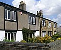 182-186 Swinnow Road - geograph.org.uk - 450862.jpg 640 × 532; 100 KB
-
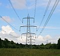 400 KV supergrid pylons in Botley Wood - geograph.org.uk - 452234.jpg 640 × 591; 135 KB
-
 A classic viewpoint - geograph.org.uk - 1719716.jpg 2,272 × 1,712; 838 KB
-

-
 A681 Bacup Todmorden Road Mileage Stone - geograph.org.uk - 450836.jpg 640 × 480; 173 KB
-
 Aberdeen - Inverness Railway Line - geograph.org.uk - 451912.jpg 480 × 640; 137 KB
-
 Access to Culthibert and Seats. - geograph.org.uk - 451051.jpg 640 × 480; 150 KB
-
 Alien invader - geograph.org.uk - 450709.jpg 640 × 480; 92 KB
-
 Allotments - Crimbles Place - geograph.org.uk - 450887.jpg 640 × 423; 118 KB
-
 Allt Coir a' Tairneilear - geograph.org.uk - 961620.jpg 427 × 640; 68 KB
-
 Ammonites - geograph.org.uk - 474674.jpg 640 × 479; 285 KB
-
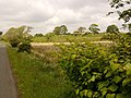
 Another field disappears - geograph.org.uk - 460504.jpg 640 × 480; 132 KB
-
 Apartments, Omagh - geograph.org.uk - 450600.jpg 640 × 479; 42 KB
-
 Approach to Tillyfourie - geograph.org.uk - 453838.jpg 640 × 480; 78 KB
-
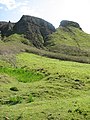
 Approaching Slemish - geograph.org.uk - 474460.jpg 640 × 427; 247 KB
-
 Approaching Worksop Town Lock - geograph.org.uk - 453354.jpg 640 × 480; 87 KB
-
 Arnold lodge &drive 31y07.JPG 2,592 × 1,944; 2.56 MB
-
 Arnold lodge 31y07.JPG 2,592 × 1,944; 2.79 MB
-
 Arnold Palmer Putting Course - geograph.org.uk - 451512.jpg 526 × 640; 116 KB
-
 Astwith Lane - geograph.org.uk - 596104.jpg 640 × 360; 94 KB
-

-

-
 Ballycoos - geograph.org.uk - 473695.jpg 640 × 427; 271 KB
-
 Ballygally - geograph.org.uk - 474677.jpg 640 × 398; 218 KB
-
 Ballygawn - geograph.org.uk - 454795.jpg 640 × 427; 99 KB
-
 Barford St Michael sewage works - geograph.org.uk - 451373.jpg 640 × 395; 77 KB
-
 Barnearnie farm. - geograph.org.uk - 451042.jpg 640 × 386; 65 KB
-
 Beinn Eighe Ruadh-stac Mor.jpg 3,347 × 2,231; 2.15 MB
-
 Beinn Eighe Sail Mhor.jpg 3,456 × 2,304; 1.69 MB
-
 Beinn Eighe.jpg 3,456 × 2,304; 3.07 MB
-
 Bent bollard, Omagh - geograph.org.uk - 450602.jpg 640 × 479; 67 KB
-

-
 Bescot Junction - geograph.org.uk - 451032.jpg 600 × 450; 221 KB
-
 Bescot Station - geograph.org.uk - 451006.jpg 600 × 450; 178 KB
-
 Bescot Station Car Park - geograph.org.uk - 451056.jpg 600 × 450; 179 KB
-
 Betws Park Boulder - geograph.org.uk - 959265.jpg 640 × 426; 106 KB
-
 Birker Force - geograph.org.uk - 456477.jpg 480 × 640; 56 KB
-
 Birker Force - geograph.org.uk - 456479.jpg 480 × 640; 67 KB
-
 Blackingrove Farm gate - geograph.org.uk - 451360.jpg 640 × 402; 83 KB
-
 Bloxham Grove post mill - geograph.org.uk - 451294.jpg 640 × 640; 97 KB
-
 Boat port, Alticry - geograph.org.uk - 450696.jpg 640 × 480; 92 KB
-
 Boreland Quarry - geograph.org.uk - 450970.jpg 640 × 480; 88 KB
-
 Borough Street, Hove - geograph.org.uk - 459482.jpg 640 × 480; 118 KB
-
 Borrowdale above Seathwaite - geograph.org.uk - 1719841.jpg 2,272 × 1,712; 1 MB
-
 Borrowdale below Seathwaite - geograph.org.uk - 1719242.jpg 2,272 × 1,712; 950 KB
-
 Bothy at Glen Garrisdale - geograph.org.uk - 1087260.jpg 640 × 480; 78 KB
-
 Bracebridge Lock, Chesterfield Canal - geograph.org.uk - 453328.jpg 640 × 480; 106 KB
-
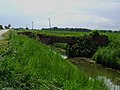
 Brenzett Sewer - geograph.org.uk - 451502.jpg 640 × 427; 87 KB
-
 Bridge - geograph.org.uk - 451370.jpg 640 × 480; 131 KB
-
 Bridge Before Bracebridge Lock - geograph.org.uk - 453316.jpg 640 × 480; 98 KB
-
 Bridge building, Omagh - geograph.org.uk - 450603.jpg 640 × 479; 80 KB
-
 Bridge building, Omagh - geograph.org.uk - 450604.jpg 640 × 479; 74 KB
-
 Bridge in Botley Wood - geograph.org.uk - 451165.jpg 640 × 427; 295 KB
-
 Bridge over North Idle Drain - geograph.org.uk - 450713.jpg 640 × 480; 97 KB
-
 Bridleway to Thoresway - geograph.org.uk - 452375.jpg 640 × 427; 72 KB
-
 Bristow Cottage - geograph.org.uk - 458283.jpg 640 × 480; 143 KB
-
 Bruichladdich Distillery - geograph.org.uk - 470718.jpg 640 × 480; 100 KB
-
 Bruichladdich Post Office - geograph.org.uk - 470208.jpg 640 × 480; 95 KB
-
 Bugs on barley - geograph.org.uk - 451403.jpg 480 × 640; 264 KB
-

-
 Canadian Geese, Osberton - geograph.org.uk - 452758.jpg 640 × 480; 78 KB
-
 Carnstroan - geograph.org.uk - 474424.jpg 640 × 427; 249 KB
-
 Causeway to an Island in Loch Beag - geograph.org.uk - 453329.jpg 640 × 384; 106 KB
-
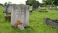
 Cemetery off Larpool Lane - geograph.org.uk - 451459.jpg 640 × 480; 102 KB
-
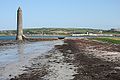 Chaine Memorial Tower - geograph.org.uk - 474644.jpg 640 × 427; 234 KB
-
 Chambered Cairn, Kilmartin - geograph.org.uk - 470131.jpg 640 × 427; 73 KB
-
 Chester City Mission, Hunter Street - geograph.org.uk - 451073.jpg 640 × 480; 167 KB
-
 Chester City Mission, Princess Street - geograph.org.uk - 451031.jpg 640 × 480; 173 KB
-
 Chester City Mission, Princess Street - geograph.org.uk - 451062.jpg 640 × 480; 152 KB
-
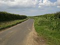 Choseley Road looking north - geograph.org.uk - 451477.jpg 640 × 480; 101 KB
-
 Choseley Road running north west - geograph.org.uk - 451479.jpg 640 × 480; 97 KB
-
 Church tower - geograph.org.uk - 451058.jpg 480 × 640; 125 KB
-
 Clachnaharry - The Lockkeeper's House - geograph.org.uk - 677818.jpg 640 × 425; 51 KB
-
 Clifton Hill, Hove - geograph.org.uk - 459475.jpg 640 × 480; 100 KB
-
 Clinton Street Bridge - geograph.org.uk - 451364.jpg 640 × 480; 100 KB
-
 Clouded Magpie (Abraxas sylvata) - geograph.org.uk - 1230027.jpg 640 × 480; 57 KB
-
 Coir' a' Tairneilear - geograph.org.uk - 1062533.jpg 640 × 427; 101 KB
-
 Common Dog Violet (Viola riviniana) - geograph.org.uk - 473679.jpg 640 × 440; 301 KB
-
 Common Lizard - geograph.org.uk - 450704.jpg 640 × 461; 143 KB
-
 Conway Street, Hove - geograph.org.uk - 461388.jpg 640 × 480; 101 KB
-
 Corinch. - geograph.org.uk - 450922.jpg 640 × 480; 85 KB
-
 Cortrystie. - geograph.org.uk - 450935.jpg 640 × 480; 80 KB
-
 Cottage at Daisy Bank - geograph.org.uk - 451392.jpg 640 × 480; 201 KB
-
 Course of old railway - geograph.org.uk - 451252.jpg 640 × 480; 97 KB
-
 Creag Mhor - geograph.org.uk - 872510.jpg 480 × 640; 110 KB
-
 Croxby view - geograph.org.uk - 451310.jpg 640 × 427; 57 KB
-
 Cwarelau Wood - geograph.org.uk - 451152.jpg 640 × 427; 238 KB
-
 Dalegarth Station - geograph.org.uk - 456451.jpg 640 × 480; 122 KB
-
 Death at Lazyfold farm - geograph.org.uk - 451354.jpg 480 × 640; 186 KB
-
 Dismantled railway by Sauchen road - geograph.org.uk - 454969.jpg 640 × 480; 130 KB
-
 Disused Quarry - geograph.org.uk - 456439.jpg 640 × 480; 141 KB
-
 Doctor Bridge - geograph.org.uk - 456465.jpg 640 × 480; 198 KB
-
 Door to the Old Custom House Building - geograph.org.uk - 831965.jpg 480 × 640; 194 KB
-
 Down the Wye towards the Welsh border - geograph.org.uk - 450966.jpg 640 × 421; 220 KB
-
 Driveway to Castle Fraser - geograph.org.uk - 458251.jpg 640 × 480; 107 KB
-
 Drumwhern. - geograph.org.uk - 451072.jpg 640 × 480; 81 KB
-
 Duke of York - geograph.org.uk - 451409.jpg 630 × 472; 155 KB
-
 Dun Beag - geograph.org.uk - 1062501.jpg 640 × 427; 62 KB
-
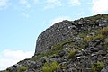 Dun Beag Broch - geograph.org.uk - 961829.jpg 640 × 427; 67 KB
-
 Dun Beag stairwell - geograph.org.uk - 1062510.jpg 427 × 640; 89 KB
-
 Duncanstone - geograph.org.uk - 451380.jpg 480 × 640; 131 KB
-
 Dunecht.jpg 640 × 480; 87 KB
-
 Dunvegan Castle and Loch Dunvegan - geograph.org.uk - 508389.jpg 640 × 480; 76 KB
-
 Easdale. - geograph.org.uk - 450893.jpg 640 × 427; 284 KB
-
 East Lodge, Cluny Castle - geograph.org.uk - 455015.jpg 640 × 480; 130 KB
-
 East side of Monymusk Square - geograph.org.uk - 454664.jpg 640 × 480; 119 KB
-
 Entrance Monymusk Church.jpg 640 × 483; 88 KB
-
 Public telephone Box - geograph.org.uk - 450707.jpg 640 × 480; 135 KB
-
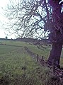
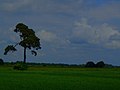 Lone Tree - geograph.org.uk - 450739.jpg 640 × 480; 44 KB
-
 Eskdale Railway Station - geograph.org.uk - 455470.jpg 640 × 480; 185 KB
-
 Euphydryas aurinia - geograph.org.uk - 483403.jpg 640 × 480; 156 KB
-

-
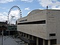 Event Horizon, RFH and London Eye - geograph.org.uk - 452991.jpg 640 × 480; 61 KB
-
 Farm building on Scawcett Lane - geograph.org.uk - 450725.jpg 640 × 480; 99 KB
-
 Fence and Wall - geograph.org.uk - 452215.jpg 476 × 640; 201 KB
-

-
 Fisherground Farm Campsite - geograph.org.uk - 456489.jpg 640 × 480; 179 KB
-
 Fisherground Halt - geograph.org.uk - 456486.jpg 640 × 480; 181 KB
-

-
 Footbridge over stream in Botley Wood - geograph.org.uk - 452219.jpg 640 × 427; 302 KB
-
 Footpath - geograph.org.uk - 451108.jpg 640 × 480; 93 KB
-
 Footpath - geograph.org.uk - 596728.jpg 640 × 360; 108 KB
-
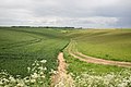
 Footpath through barley field - geograph.org.uk - 451384.jpg 640 × 480; 266 KB
-
 Ford footbridge at Lowdales - geograph.org.uk - 456808.jpg 640 × 480; 95 KB
-
 Foreshore - geograph.org.uk - 550542.jpg 640 × 480; 70 KB
-
 Former Post Office - Lowtown - geograph.org.uk - 450875.jpg 640 × 588; 110 KB
-
 Fraser Mausoleum, Cluny kirkyard. - geograph.org.uk - 458465.jpg 569 × 635; 100 KB
-
 From Coire na Creiche - geograph.org.uk - 1062525.jpg 640 × 427; 63 KB
-

-
 Garheugh Port - geograph.org.uk - 450688.jpg 640 × 480; 105 KB
-
 Gate on Coremachy. - geograph.org.uk - 451026.jpg 640 × 480; 60 KB
-
 Gate to Thorpe Satville - geograph.org.uk - 1054053.jpg 640 × 480; 124 KB
-
 Gateway to the Oast House - geograph.org.uk - 451181.jpg 640 × 480; 97 KB
-
 Memorial Stone - geograph.org.uk - 452673.jpg 2,631 × 1,481; 916 KB
-
 Gillercomb - geograph.org.uk - 1719827.jpg 2,272 × 1,712; 1.03 MB
-
 Glen Brittle Beach - geograph.org.uk - 961228.jpg 640 × 427; 60 KB
-
 Glen Brittle North beach - geograph.org.uk - 961231.jpg 640 × 427; 56 KB
-
 Glen Nevis - geograph.org.uk - 1025230.jpg 640 × 480; 157 KB
-
 Glenling Burn - geograph.org.uk - 450698.jpg 640 × 480; 114 KB
-
 The White Hart Inn - geograph.org.uk - 453908.jpg 640 × 480; 80 KB
-
 Great Chart Village Sign - geograph.org.uk - 529940.jpg 480 × 640; 123 KB
-
 Great Chart Village Sign - geograph.org.uk - 529945.jpg 480 × 640; 122 KB
-
 Great Gable from Green Gable - geograph.org.uk - 1719255.jpg 2,272 × 1,712; 1.45 MB
-

-
 Footpath towards Grimsby - geograph.org.uk - 450810.jpg 640 × 427; 65 KB
-
 Scartho farmland - geograph.org.uk - 450807.jpg 640 × 427; 66 KB
-
 Grindleton Methodist Church - geograph.org.uk - 451397.jpg 640 × 480; 167 KB
-
 Grunay.jpg 455 × 341; 40 KB
-
 Gunnerby sub-station - geograph.org.uk - 450827.jpg 640 × 427; 63 KB
-
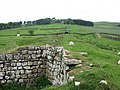
 Hadrian's Wall - geograph.org.uk - 451046.jpg 480 × 640; 106 KB
-
-
 Haltemprice Priory Farm - geograph.org.uk - 451642.jpg 640 × 455; 86 KB
-
 Hare Bells - geograph.org.uk - 458591.jpg 640 × 480; 186 KB
-
 Heath Strange Garden - geograph.org.uk - 455526.jpg 640 × 480; 119 KB
-
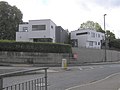
 Heathlands Veterinary Hospital - geograph.org.uk - 454242.jpg 640 × 426; 73 KB
-

-
 High Glenling farm. - geograph.org.uk - 450705.jpg 640 × 480; 129 KB
-
 Homemade vehicle^ - geograph.org.uk - 451413.jpg 480 × 640; 128 KB
-
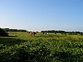 Horses grazing near Mount Ararat - geograph.org.uk - 450987.jpg 640 × 480; 91 KB
-
 Houses in Swinnow Road - geograph.org.uk - 450813.jpg 640 × 355; 75 KB
-
 Hove Lawns, Hove - geograph.org.uk - 461386.jpg 640 × 480; 112 KB
-
 I see no ships - geograph.org.uk - 451348.jpg 480 × 640; 136 KB
-
 Ilfracombe Harbour Evening - geograph.org.uk - 752817.jpg 427 × 640; 66 KB
-
 In Need of Care and Attention. - geograph.org.uk - 450732.jpg 640 × 480; 114 KB
-
 Inch Kenneth - geograph.org.uk - 869362.jpg 640 × 434; 79 KB
-
 Irton Road Station sign - geograph.org.uk - 455455.jpg 640 × 480; 182 KB
-
 Irton Road Station.jpg 640 × 480; 187 KB
-
 Jamiatul Ilm Wal Huda Mosque - geograph.org.uk - 451357.jpg 640 × 480; 184 KB
-
 Jetty, Eilean Loain - geograph.org.uk - 453012.jpg 640 × 384; 56 KB
-
 Kilton Lock - geograph.org.uk - 453302.jpg 640 × 480; 86 KB
-
 King George iv Inn, Eskdale Green - geograph.org.uk - 455474.jpg 640 × 480; 132 KB
-
 KingArthursCommunitySchool.jpg 640 × 480; 89 KB
-
 Kirton creek at low tide - geograph.org.uk - 452503.jpg 640 × 480; 66 KB
-
 LC - geograph.org.uk - 454155.jpg 640 × 426; 72 KB
-
 Levisham Station - geograph.org.uk - 659754.jpg 640 × 429; 78 KB
-
 Levisham Station - geograph.org.uk - 659755.jpg 640 × 429; 78 KB
-
 Levisham Station - geograph.org.uk - 659757.jpg 630 × 422; 104 KB
-
 Levisham Station - geograph.org.uk - 659758.jpg 640 × 429; 75 KB
-
 Levisham Station Signal Box - geograph.org.uk - 659759.jpg 409 × 610; 106 KB
-
 Levisham Station Signal Box - geograph.org.uk - 659760.jpg 570 × 382; 102 KB
-
 Levisham Station Signal Box - geograph.org.uk - 659761.jpg 640 × 429; 79 KB
-
 Linenhall Stables side entrance - geograph.org.uk - 1280204.jpg 640 × 480; 159 KB
-
 Linford Ancient Site - geograph.org.uk - 473660.jpg 640 × 427; 269 KB
-
 Linford Ancient Site - geograph.org.uk - 473661.jpg 640 × 427; 217 KB
-
 Linford Ancient Site - geograph.org.uk - 473666.jpg 640 × 427; 275 KB
-
 Loch Dunvegan from the south - geograph.org.uk - 954660.jpg 640 × 480; 90 KB
-
 Loch Suardal, near Dunvegan, Skye - geograph.org.uk - 957233.jpg 640 × 480; 61 KB
-
 Loch Suardal, near Dunvegan, Skye - geograph.org.uk - 957239.jpg 640 × 480; 76 KB
-
 Lochan a' Mhaim - geograph.org.uk - 961571.jpg 640 × 427; 44 KB
-
 Lolworth village - geograph.org.uk - 457281.jpg 640 × 480; 130 KB
-
 Lolworth village hall - geograph.org.uk - 457290.jpg 640 × 480; 167 KB
-
 Looking Towards Slemish - geograph.org.uk - 474442.jpg 640 × 427; 243 KB
-
 Love Lane, EC2 - geograph.org.uk - 827480.jpg 640 × 480; 109 KB
-
 Low Dales and Carr Lands - geograph.org.uk - 456832.jpg 640 × 480; 52 KB
-
 St Catherine, Ludham, Norfolk - geograph.org.uk - 484013.jpg 640 × 369; 79 KB
-
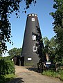 Ludham How Hill Mill.jpg 484 × 640; 127 KB
-

-
 Manton Viaduct, Chesterfield Canal - geograph.org.uk - 453275.jpg 640 × 480; 76 KB
-
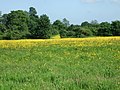 Martin's Meadow - geograph.org.uk - 670951.jpg 640 × 480; 115 KB


_-_geograph.org.uk_-_1230027.jpg)

_-_geograph.org.uk_-_473679.jpg)


_-_geograph.org.uk_-_1116526.jpg)


