Category:United Kingdom photographs taken on 2007-12-31
Countries of Europe: Austria · Bulgaria · Czech Republic · Denmark · Finland · France‡ · Georgia‡ · Germany · Italy · Kazakhstan‡ · Latvia · Lithuania · Netherlands‡ · Norway · Poland · Portugal‡ · Romania · Russia‡ · Slovakia · Spain‡ · Sweden · Ukraine · United Kingdom
‡: partly located in Europe
‡: partly located in Europe
| ← | 31 December 2007 | → | ||
| ← | December 2007 | → | ||

United Kingdom photographs taken on 31 December 2007.
Image files should be categorized here automatically using {{taken on}} template. Direct categorisation is also possible, if automatic is impossible.
Subcategories
This category has only the following subcategory.
S
Media in category "United Kingdom photographs taken on 2007-12-31"
The following 200 files are in this category, out of 554 total.
(previous page) (next page)-
 "How's the crack", Arvalee - geograph.org.uk - 644632.jpg 640 × 492; 63 KB
-

-

-

-
 A survivor - geograph.org.uk - 645055.jpg 427 × 640; 137 KB
-

-
 A401 Theobald's Road - geograph.org.uk - 653636.jpg 640 × 480; 82 KB
-
 A401 Theobald's Road - geograph.org.uk - 668731.jpg 640 × 480; 75 KB
-
 Abbey gateway.jpg 480 × 640; 201 KB
-
 Abbey Square - north side - geograph.org.uk - 668073.jpg 640 × 480; 194 KB
-
 All Saints Church, Brantingham - geograph.org.uk - 657153.jpg 640 × 425; 66 KB
-
-
 All Saints Church, Hilborough, Norfolk - geograph.org.uk - 697593.jpg 640 × 480; 128 KB
-

-

-

-
 All Saints Church, Threxton, Norfolk - geograph.org.uk - 697575.jpg 640 × 480; 64 KB
-

-

-
 Allendale Town Tar Bar'l - geograph.org.uk - 649541.jpg 640 × 480; 93 KB
-
 Allendale Town Tar Bar'l - geograph.org.uk - 649565.jpg 640 × 480; 74 KB
-

-
 Ancient ruin on Carn Mor - geograph.org.uk - 645080.jpg 640 × 426; 80 KB
-
 Anwoth Road - geograph.org.uk - 651931.jpg 640 × 480; 73 KB
-
 Approaching Beeley Hilltop - geograph.org.uk - 650136.jpg 640 × 480; 145 KB
-

-
 Barlborough 644978 7ee2f087.jpg 640 × 480; 75 KB
-
 Barn and old orchard - geograph.org.uk - 644739.jpg 640 × 480; 88 KB
-
 Base for wind turbine - geograph.org.uk - 647923.jpg 640 × 480; 58 KB
-

-
-
 Beeley Hilltop - geograph.org.uk - 650615.jpg 480 × 640; 116 KB
-
 Bend on Rossendale Way - geograph.org.uk - 646388.jpg 640 × 480; 71 KB
-
 Big bus co at speakers corner.jpg 640 × 427; 70 KB
-
 Bird's-Eye View - geograph.org.uk - 645130.jpg 480 × 640; 117 KB
-
 Blackhazel Beck - geograph.org.uk - 645797.jpg 640 × 427; 75 KB
-
 Blue Plaque in Abbey Square - geograph.org.uk - 668059.jpg 640 × 480; 219 KB
-
 Blue Plaque in Godstall Lane - geograph.org.uk - 667723.jpg 640 × 480; 187 KB
-
 Boats in Portree Bay - geograph.org.uk - 645203.jpg 640 × 480; 65 KB
-
 Boats on the Beach, Worthing, West Sussex - geograph.org.uk - 647771.jpg 1,024 × 714; 423 KB
-
 Bog at Arvalee - geograph.org.uk - 644610.jpg 640 × 290; 39 KB
-
 Bog at Arvalee - geograph.org.uk - 644649.jpg 640 × 278; 54 KB
-
 Boreland Hills - geograph.org.uk - 651897.jpg 640 × 480; 79 KB
-
 Boreland Hills - geograph.org.uk - 651921.jpg 640 × 480; 56 KB
-
 Boscobel Place - geograph.org.uk - 645614.jpg 427 × 640; 155 KB
-

-

-
 Bracken on access land near Chatsworth - geograph.org.uk - 650664.jpg 640 × 480; 120 KB
-
 Bridge House - geograph.org.uk - 650054.jpg 480 × 640; 150 KB
-
 Brighton Road, Worthing, West Sussex - geograph.org.uk - 647793.jpg 640 × 463; 130 KB
-
 Brook at Jubilee - geograph.org.uk - 645162.jpg 640 × 480; 115 KB
-
 Broomhall farm and outbuildings - geograph.org.uk - 644914.jpg 640 × 387; 49 KB
-
 Building near Will Pitts - geograph.org.uk - 645109.jpg 640 × 480; 81 KB
-
 Buildings at Former Colliery - geograph.org.uk - 645327.jpg 640 × 480; 74 KB
-
 Burn, Boreland Hills - geograph.org.uk - 651906.jpg 640 × 480; 138 KB
-
-
 Canterbury Law Courts.jpg 640 × 480; 147 KB
-
 Canterbury windmill.jpg 480 × 640; 174 KB
-
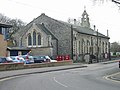 All Saints church on Military Road - geograph.org.uk - 645349.jpg 640 × 480; 158 KB
-

-
 Carving in the city walls - geograph.org.uk - 665212.jpg 640 × 480; 195 KB
-
 Cathedral Buildings - geograph.org.uk - 667706.jpg 480 × 640; 145 KB
-
 Cathedral Buildings side window - geograph.org.uk - 667715.jpg 480 × 640; 182 KB
-
 Cathedral Song School - geograph.org.uk - 667900.jpg 640 × 480; 178 KB
-
-
 Charing Cross and the Playhouse Theatre - geograph.org.uk - 646636.jpg 640 × 427; 205 KB
-
 Chatsworth Park - geograph.org.uk - 650130.jpg 480 × 640; 119 KB
-

-
 Chester Cathedral from Abbey Street - geograph.org.uk - 667967.jpg 640 × 480; 165 KB
-
 Chester Town Hall - Lord Mayoralty Gates - geograph.org.uk - 667686.jpg 480 × 640; 191 KB
-
 Chester Town Hall entrance tableau ^1 - geograph.org.uk - 667657.jpg 640 × 480; 143 KB
-
 Chester Town Hall entrance tableau ^2 - geograph.org.uk - 667662.jpg 640 × 480; 135 KB
-
 Chester Town Hall entrance tableau ^4 - geograph.org.uk - 667667.jpg 640 × 480; 148 KB
-
 Addleshaw Tower window - geograph.org.uk - 667727.jpg 480 × 640; 155 KB
-
 Christmas lights in Mousehole Harbour - geograph.org.uk - 653906.jpg 640 × 457; 76 KB
-
 Church End, Cherry Hinton - geograph.org.uk - 644770.jpg 640 × 510; 71 KB
-
 City centre Perth - geograph.org.uk - 650203.jpg 600 × 450; 114 KB
-
 City Walls above the Kaleyard Gate - geograph.org.uk - 665204.jpg 640 × 480; 215 KB
-
 City walls and blocked doorway - geograph.org.uk - 667897.jpg 640 × 480; 209 KB
-
 Clearing in the Woods - geograph.org.uk - 645768.jpg 640 × 480; 106 KB
-
 Cliff of Peat - geograph.org.uk - 645269.jpg 480 × 640; 83 KB
-
 Clock detail on Cathedral Buildings - geograph.org.uk - 667709.jpg 480 × 640; 225 KB
-

-

-
 Collapsed hoardings on Sealand Road - geograph.org.uk - 679308.jpg 640 × 480; 161 KB
-
 Colourful Guest Houses, Worthing, West Sussex - geograph.org.uk - 647762.jpg 1,440 × 929; 1.44 MB
-
 Comfy Seat - geograph.org.uk - 645399.jpg 480 × 640; 140 KB
-

-
 Cottage, Anwoth - geograph.org.uk - 651923.jpg 640 × 480; 109 KB
-
 Cromford Canal - geograph.org.uk - 680055.jpg 640 × 480; 111 KB
-
 Crossing to the Cop Park - geograph.org.uk - 679264.jpg 640 × 480; 229 KB
-
 Crown Mines 2.jpg 640 × 427; 95 KB
-

-
 Dam wall of Clunas reservoir - geograph.org.uk - 645119.jpg 640 × 426; 41 KB
-
 Deverney Road, Arvalee - geograph.org.uk - 644618.jpg 640 × 257; 29 KB
-
 Discovery - geograph.org.uk - 650195.jpg 600 × 450; 74 KB
-
 Dismantled railway line - geograph.org.uk - 700025.jpg 640 × 430; 121 KB
-
 Donaghanie Road - geograph.org.uk - 644656.jpg 640 × 300; 36 KB
-
 Dowson Garth - geograph.org.uk - 700028.jpg 640 × 430; 75 KB
-
 Dry lodge near Paradise - geograph.org.uk - 647912.jpg 640 × 480; 76 KB
-
 Dukeries Garden Centre Car Park - geograph.org.uk - 645104.jpg 640 × 480; 70 KB
-
 Dyffryn Arth - geograph.org.uk - 644789.jpg 640 × 480; 55 KB
-
 Eastnor Castle - geograph.org.uk - 644967.jpg 640 × 480; 61 KB
-
 Eaton Mews West - geograph.org.uk - 645612.jpg 427 × 640; 138 KB
-
 Eaton Terrace - geograph.org.uk - 645603.jpg 640 × 451; 159 KB
-
 Ebury Mews - geograph.org.uk - 645633.jpg 640 × 427; 159 KB
-
 Edge of Stand Wood - geograph.org.uk - 648036.jpg 485 × 640; 155 KB
-
 Eilean Donan Castle - geograph.org.uk - 654804.jpg 640 × 480; 66 KB
-
 Eller Beck - geograph.org.uk - 700005.jpg 640 × 430; 123 KB
-
 Emerald Street - geograph.org.uk - 668729.jpg 640 × 480; 74 KB
-
 East Meets West - geograph.org.uk - 645091.jpg 640 × 480; 117 KB
-
 Entrance to The Cop park - geograph.org.uk - 679268.jpg 640 × 480; 230 KB
-
 Entrance to The Cop park - geograph.org.uk - 679295.jpg 640 × 480; 215 KB
-
 Entrance to The Harley Gallery - geograph.org.uk - 645089.jpg 640 × 480; 74 KB
-

-
 Ewell East station - geograph.org.uk - 647698.jpg 640 × 427; 77 KB
-
 Feeding the Birds - geograph.org.uk - 645436.jpg 640 × 427; 144 KB
-

-
 Fence posts atop Carn Mor - geograph.org.uk - 644964.jpg 640 × 426; 47 KB
-
 First railway tunnel in the world^ - geograph.org.uk - 700013.jpg 430 × 640; 77 KB
-

-

-
 Gateway to Building - geograph.org.uk - 645117.jpg 640 × 480; 82 KB
-
 Gatwick Express - geograph.org.uk - 646501.jpg 640 × 427; 145 KB
-
 Lone tree - geograph.org.uk - 645038.jpg 640 × 427; 63 KB
-
 Sheep - geograph.org.uk - 645043.jpg 640 × 427; 101 KB
-
 Gautby village hall - geograph.org.uk - 645039.jpg 640 × 427; 94 KB
-
 Glasffrwd stream - geograph.org.uk - 644898.jpg 640 × 480; 125 KB
-
 Godstall Lane from St Werburgh Street. - geograph.org.uk - 667724.jpg 480 × 640; 185 KB
-
 Goole Moors - geograph.org.uk - 645185.jpg 640 × 480; 95 KB
-
 Graffiti in The Cop park - geograph.org.uk - 679287.jpg 640 × 480; 258 KB
-
 Grassy lane - geograph.org.uk - 651884.jpg 480 × 640; 100 KB
-
 Grosmont church - geograph.org.uk - 700008.jpg 640 × 430; 107 KB
-
 Grosmont village and railway station - geograph.org.uk - 700022.jpg 640 × 430; 78 KB
-
 Groynes on Worthing Beach, West Sussex - geograph.org.uk - 647804.jpg 640 × 424; 139 KB
-
 Hans Street - geograph.org.uk - 645595.jpg 640 × 427; 178 KB
-
 Harbour lights - geograph.org.uk - 645485.jpg 640 × 443; 51 KB
-
 Chambers Farm Wood - geograph.org.uk - 644909.jpg 640 × 427; 97 KB
-
 Hedged Hawthorn - geograph.org.uk - 645092.jpg 640 × 427; 132 KB
-
 High St. at Christmas - geograph.org.uk - 679224.jpg 640 × 480; 90 KB
-
 HillEndStationPlatform20071231.jpg 1,200 × 900; 342 KB
-
 Hogmanay 2007 in Biggar - geograph.org.uk - 645570.jpg 640 × 480; 39 KB
-
 Hollins seen across a field - geograph.org.uk - 700049.jpg 640 × 430; 53 KB
-
 Horses on Swallowcliffe Down - geograph.org.uk - 644959.jpg 640 × 480; 57 KB
-
 House on Hill in Barmouth - geograph.org.uk - 649557.jpg 640 × 427; 66 KB
-
 Hut circle on the slopes of Carn Mor - geograph.org.uk - 645010.jpg 640 × 426; 68 KB
-
 Hyde Park Barracks - geograph.org.uk - 645465.jpg 640 × 427; 181 KB
-
 Hyde Park Barracks - geograph.org.uk - 645467.jpg 427 × 640; 234 KB
-
 Information Post, Rossendale way - geograph.org.uk - 647904.jpg 480 × 640; 104 KB
-
 Junction with Bolahaul Road - geograph.org.uk - 644848.jpg 640 × 480; 70 KB
-
 Kew Gardens station - geograph.org.uk - 831381.jpg 640 × 480; 62 KB
-
 King's Road, Eaton Square - geograph.org.uk - 645606.jpg 640 × 427; 173 KB
-
 Kingsmead Leisure Centre - geograph.org.uk - 647217.jpg 640 × 480; 162 KB
-
 Farm Outbuildings - geograph.org.uk - 647265.jpg 640 × 480; 111 KB
-
 Lane approaching Funglas - geograph.org.uk - 646322.jpg 640 × 425; 70 KB
-
 Lane heading past Llethercynon - geograph.org.uk - 646309.jpg 640 × 425; 64 KB
-

-
 Lane to Garthbrengy - geograph.org.uk - 646260.jpg 640 × 425; 68 KB
-
 Lane up to Llwyncynog - geograph.org.uk - 646456.jpg 640 × 425; 90 KB
-

-
 Late Night Swans (2153551402).jpg 2,384 × 1,404; 2.31 MB
-
 Ledbury Bowling Club Green - geograph.org.uk - 644816.jpg 640 × 480; 67 KB
-
 Leg It^ - geograph.org.uk - 645149.jpg 640 × 480; 140 KB
-
 Levant steam engine - geograph.org.uk - 655154.jpg 640 × 427; 43 KB
-
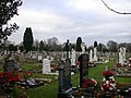
 Llangollen town Cemetery - geograph.org.uk - 645248.jpg 640 × 428; 81 KB
-
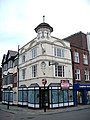
 Local shop on the outskirts of Canterbury - geograph.org.uk - 645360.jpg 640 × 480; 157 KB
-
 Loch Duich - geograph.org.uk - 654767.jpg 640 × 480; 37 KB
-
 Loch Garten - geograph.org.uk - 653866.jpg 640 × 480; 43 KB
-
 Lodge above Twine Valley Country Park - geograph.org.uk - 646230.jpg 640 × 480; 85 KB
-
 London - Krishna locations on Soho Street - panoramio.jpg 896 × 672; 198 KB
-
 London - Soho Square - panoramio.jpg 896 × 672; 295 KB
-
 London - The Tottenham on Oxford Street - panoramio.jpg 672 × 896; 213 KB
-
 London - view from the Eye towards Charing Cross Station - panoramio.jpg 896 × 672; 161 KB
-

-

-

-
 London Bus route 137.jpg 3,648 × 2,736; 4.34 MB
-
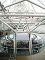 London Eye - cabin - panoramio.jpg 672 × 896; 199 KB
-
 London Eye - from Chicheley Street. - panoramio.jpg 672 × 896; 118 KB
-

-
 London Parliament seen from the London Eye - panoramio.jpg 896 × 672; 189 KB
-
 London, UK - panoramio - jeffwarder.jpg 896 × 672; 202 KB
-
 London, UK - panoramio.jpg 896 × 672; 184 KB
-
 Long plantation at Ercall Heath - geograph.org.uk - 644715.jpg 640 × 480; 33 KB
-
 Looking towards Cuckney Cricket Club - geograph.org.uk - 645126.jpg 640 × 480; 68 KB
-
 Looking up to Ty-Canol - geograph.org.uk - 646286.jpg 640 × 425; 71 KB
-
 Mallards on White Loch - geograph.org.uk - 650707.jpg 640 × 426; 39 KB
-
 Matlock Bath - A6 - geograph.org.uk - 680034.jpg 640 × 480; 160 KB
-
 Mayfair, London, UK - panoramio.jpg 672 × 896; 203 KB
-
 Mill, Gatehouse of Fleet - geograph.org.uk - 651882.jpg 640 × 480; 82 KB
-

-
 Mince Pie Special - geograph.org.uk - 645240.jpg 640 × 428; 85 KB
-

-
 Minor road near Llandegla. - geograph.org.uk - 644731.jpg 640 × 480; 122 KB
-
 Minor road near Moel y Waun. - geograph.org.uk - 644932.jpg 480 × 640; 126 KB
-
 Minor road. - geograph.org.uk - 644942.jpg 640 × 480; 62 KB
-
 Minor Road. - geograph.org.uk - 644948.jpg 640 × 480; 77 KB
-
 Leaving Minting Wood - geograph.org.uk - 644921.jpg 640 × 427; 121 KB
-
 Mist over Cowpe Moss - geograph.org.uk - 647929.jpg 640 × 480; 61 KB
-
 Monk Myre - geograph.org.uk - 650942.jpg 640 × 426; 34 KB


.jpg)


_-_panoramio.jpg)


