Category:United Kingdom photographs taken on 2008-06-06
Countries of Europe: Armenia‡ · Belarus · Belgium · Czech Republic · Denmark · Finland · France‡ · Germany · Greece · Hungary · Republic of Ireland · Italy · Latvia · Netherlands‡ · Norway · Poland · Portugal‡ · Romania · Russia‡ · Slovakia · Spain‡ · Sweden · Turkey‡ · Ukraine · United Kingdom
Specific status: Isle of Man
‡: partly located in Europe
Specific status: Isle of Man
‡: partly located in Europe
| ← | 6 June 2008 | → | ||
| ← | June 2008 | → | ||

United Kingdom photographs taken on 6 June 2008.
Image files should be categorized here automatically using {{taken on}} template. Direct categorisation is also possible, if automatic is impossible.
Subcategories
This category has the following 2 subcategories, out of 2 total.
Media in category "United Kingdom photographs taken on 2008-06-06"
The following 200 files are in this category, out of 925 total.
(previous page) (next page)-
 "The Warrior's Grave", Kilnaughton - geograph.org.uk - 865596.jpg 640 × 480; 107 KB
-
 156443 Castleton East Junction.jpg 1,024 × 768; 613 KB
-

-

-
 A complex of sheepfolds - geograph.org.uk - 836760.jpg 640 × 480; 86 KB
-
 A fairly convincing false summit - geograph.org.uk - 835433.jpg 640 × 480; 101 KB
-
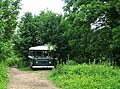 A home in a bus? - geograph.org.uk - 842000.jpg 640 × 473; 167 KB
-

-

-
 A liquid oxygen delivery completed - geograph.org.uk - 868850.jpg 427 × 640; 115 KB
-
 A view to Swift's Hill - geograph.org.uk - 841099.jpg 640 × 480; 135 KB
-
 A350 Westbury Road - geograph.org.uk - 846738.jpg 640 × 469; 68 KB
-
 A417, hamlet called Aldworth - panoramio.jpg 4,000 × 3,000; 4.35 MB
-

-

-

-

-
 Abutment of dismantled railway bridge - geograph.org.uk - 1725940.jpg 640 × 480; 342 KB
-
 Airedale Mills - Micklethwaite Lane - geograph.org.uk - 835020.jpg 640 × 434; 39 KB
-
 Aith sunset - geograph.org.uk - 834799.jpg 640 × 426; 47 KB
-
 Albany Road Allotments, Bishop's Waltham - geograph.org.uk - 842176.jpg 640 × 427; 139 KB
-

-
 Allotments - Micklethwaite Lane - geograph.org.uk - 835016.jpg 640 × 421; 56 KB
-

-

-

-
 Arcade - geograph.org.uk - 834495.jpg 640 × 480; 76 KB
-
 Arcade building, Westgate, Bradford - geograph.org.uk - 834186.jpg 640 × 455; 66 KB
-

-
 Ashford Carbonel - geograph.org.uk - 839703.jpg 640 × 480; 76 KB
-
 Auchendores Cottages - geograph.org.uk - 842526.jpg 640 × 480; 86 KB
-
 Baptist Chapel, Yarnbrook - geograph.org.uk - 834639.jpg 640 × 489; 86 KB
-
 Beck Road - Micklethwaite - geograph.org.uk - 834977.jpg 640 × 480; 69 KB
-
 Bingley By-pass - Keighley Road - geograph.org.uk - 835038.jpg 640 × 423; 40 KB
-
 Bingley By-pass - Keighley Road - geograph.org.uk - 835040.jpg 640 × 416; 44 KB
-
 Bingley By-pass from Park Road - geograph.org.uk - 835147.jpg 640 × 508; 47 KB
-
 Bingley Market - Main Street - geograph.org.uk - 835148.jpg 640 × 442; 49 KB
-

-

-
 Bishop's Waltham Railway Path - geograph.org.uk - 842748.jpg 427 × 640; 195 KB
-
 Bishop's Waltham Railway Path - geograph.org.uk - 842755.jpg 427 × 640; 186 KB
-
-
 Blea Tarn and the Langdale Pikes - geograph.org.uk - 838951.jpg 640 × 413; 128 KB
-
 Blue plaque on King George's Rest - geograph.org.uk - 833071.jpg 640 × 480; 53 KB
-
 Boat train to London Liverpool station.jpg 2,592 × 1,944; 1.37 MB
-
 Bog Cotton at Kilvaxter - geograph.org.uk - 833937.jpg 640 × 480; 96 KB
-
 Bog cotton by the Tweeddale Burn - geograph.org.uk - 834534.jpg 640 × 480; 88 KB
-
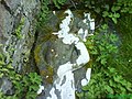
 Bogbean (Menyanthes trifoliata) - geograph.org.uk - 938834.jpg 640 × 640; 90 KB
-

-
 Boggy Hillside south of Sron Mhor - geograph.org.uk - 845150.jpg 640 × 480; 118 KB
-
 Borrowdale fields - geograph.org.uk - 878588.jpg 640 × 480; 71 KB
-
 Boundary post - geograph.org.uk - 842193.jpg 480 × 640; 110 KB
-
 Boundary post - geograph.org.uk - 842209.jpg 480 × 640; 68 KB
-
 Bournemouth , Barrack Road - geograph.org.uk - 1120193.jpg 640 × 480; 58 KB
-
 Bournemouth , Castle Parade - geograph.org.uk - 1120185.jpg 640 × 480; 69 KB
-
 Bournemouth , Deansleigh Road - geograph.org.uk - 1120150.jpg 640 × 480; 59 KB
-
 Bournemouth , East Avenue - geograph.org.uk - 1120074.jpg 640 × 480; 53 KB
-

-
 Bournemouth , Old Guardhouse - geograph.org.uk - 1120199.jpg 640 × 480; 44 KB
-
 Bournemouth , Talbot Avenue - geograph.org.uk - 1120083.jpg 640 × 480; 53 KB
-
 Bradley Road leaving North Bradley - geograph.org.uk - 846885.jpg 640 × 473; 80 KB
-
 Braidwood Farm - geograph.org.uk - 834020.jpg 640 × 480; 70 KB
-
 Bratton Road - geograph.org.uk - 834376.jpg 640 × 410; 78 KB
-
 Brickbarns Farm - pasture - geograph.org.uk - 833447.jpg 640 × 480; 63 KB
-
 Bridge at Watendlath - geograph.org.uk - 878596.jpg 640 × 480; 107 KB
-
 Bridge over Catchwater Drain - geograph.org.uk - 834295.jpg 494 × 640; 186 KB
-
 Bridge TJC3-64 - A650 - Crossflatts - geograph.org.uk - 835070.jpg 640 × 400; 35 KB
-

-
 Bridleway on slopes of Hope Mountain - geograph.org.uk - 833426.jpg 640 × 480; 99 KB
-
 Bridleway on slopes of Hope Mountain. - geograph.org.uk - 833422.jpg 480 × 640; 95 KB
-
 Bridleway through the woods - geograph.org.uk - 841989.jpg 640 × 480; 192 KB
-
 BrightonPier5808.JPG 2,048 × 1,536; 786 KB
-

-

-
 Burial Ground - Green End Road - geograph.org.uk - 834942.jpg 640 × 480; 72 KB
-
 Burlington House, Piccadilly - geograph.org.uk - 834496.jpg 640 × 559; 118 KB
-
 Bury Lane - Carr Lane, East Morton - geograph.org.uk - 834842.jpg 498 × 640; 174 KB
-
 Bus Garage and Texaco Petrol Station - geograph.org.uk - 834247.jpg 640 × 480; 73 KB
-
 Butterstor Downs - geograph.org.uk - 846731.jpg 640 × 426; 134 KB
-
 Bwlch y Gwryd - geograph.org.uk - 835157.jpg 640 × 480; 90 KB
-
 Byway near New Town, Wiltshire - geograph.org.uk - 833966.jpg 640 × 480; 148 KB
-
 Cairns in a wood near Stonethwaite - geograph.org.uk - 878686.jpg 640 × 480; 157 KB
-
 Caldrigg Fold, Staveley - geograph.org.uk - 1021665.jpg 640 × 480; 177 KB
-
 Calm waters at Gladhouse Reservoir - geograph.org.uk - 834147.jpg 640 × 480; 57 KB
-
 Carbost and the distillery - geograph.org.uk - 833476.jpg 640 × 427; 105 KB
-
 Carr Lane - geograph.org.uk - 833227.jpg 640 × 480; 77 KB
-
 Carr Lane - Micklethwaite - geograph.org.uk - 834970.jpg 640 × 524; 70 KB
-
 Carrick Du and The Island - geograph.org.uk - 835103.jpg 640 × 427; 106 KB
-
 Carwether Down - geograph.org.uk - 846772.jpg 640 × 426; 99 KB
-
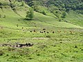 Cattle graze in Cwm Du - geograph.org.uk - 833940.jpg 640 × 480; 136 KB
-
 Cattle grid at Killantringan - geograph.org.uk - 1725840.jpg 640 × 475; 323 KB
-
 Cattle grid nr Lower Hametethy - geograph.org.uk - 846759.jpg 640 × 426; 158 KB
-
 Cefn-y-Bedd railway station in 2008.jpg 640 × 480; 100 KB
-
 Chapel Garth, Arram - geograph.org.uk - 834263.jpg 640 × 480; 181 KB
-
 Chesil beach - geograph.org.uk - 911979.jpg 640 × 480; 78 KB
-

-

-
 Christchurch, Peeks Party Store - geograph.org.uk - 1120221.jpg 640 × 480; 63 KB
-
 Church Lane, North Bradley (2) - geograph.org.uk - 846851.jpg 640 × 480; 115 KB
-
 Church Lane, North Bradley - geograph.org.uk - 834670.jpg 640 × 494; 141 KB
-
 Church Road, Heywood - geograph.org.uk - 846776.jpg 640 × 480; 63 KB
-
 Churchill Avenue, Bishop's Waltham - geograph.org.uk - 842087.jpg 640 × 427; 114 KB
-
 Circular shaped cottage - geograph.org.uk - 1725947.jpg 640 × 480; 295 KB
-
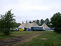 Cirque Surreal on Jesus Green - geograph.org.uk - 833813.jpg 640 × 480; 68 KB
-

-
 Clanger Wood - geograph.org.uk - 834638.jpg 640 × 447; 133 KB
-
 Clapham High Street, London SW4 - geograph.org.uk - 835410.jpg 640 × 480; 74 KB
-

-

-
 Claylands Park, Bishop's Waltham - geograph.org.uk - 841945.jpg 640 × 427; 102 KB
-
 Claylands Road, Bishop's Waltham - geograph.org.uk - 841897.jpg 640 × 427; 134 KB
-
 Clock tower at Irton Hall - geograph.org.uk - 838840.jpg 471 × 640; 189 KB
-
 Clodgy Point - geograph.org.uk - 835116.jpg 640 × 427; 97 KB
-

-
 Clyde timber ponds - geograph.org.uk - 842157.jpg 640 × 480; 103 KB
-
 Clyde timber ponds - geograph.org.uk - 842225.jpg 640 × 480; 96 KB
-
 Cnoc nan airigh Forest Walk. - geograph.org.uk - 833838.jpg 640 × 480; 93 KB
-
 Cnoc nan airigh Forest Walk. - geograph.org.uk - 833842.jpg 640 × 480; 67 KB
-
 Cnoc nan airigh Forest Walk. - geograph.org.uk - 833862.jpg 640 × 480; 68 KB
-
 Cnoc nan airigh Forest Walk. - geograph.org.uk - 834392.jpg 640 × 480; 90 KB
-
 Cnoc nan airigh Forest Walk. - geograph.org.uk - 834397.jpg 640 × 480; 74 KB
-
 Cnoc nan airigh Forest Walk. - geograph.org.uk - 834402.jpg 640 × 480; 69 KB
-
 Cnoc nan airigh Forest Walk. - geograph.org.uk - 834403.jpg 640 × 480; 87 KB
-
 Cnoc nan airigh Forest Walk. - geograph.org.uk - 834405.jpg 640 × 480; 79 KB
-
 Cnoc nan airigh Forest Walk. - geograph.org.uk - 834465.jpg 640 × 480; 122 KB
-
 Cnoc nan airigh Forest Walk. - geograph.org.uk - 834466.jpg 640 × 480; 103 KB
-
 Cnoc nan airigh Forest Walk. - geograph.org.uk - 834469.jpg 640 × 480; 102 KB
-
 Cnoc nan airigh Forest Walk. - geograph.org.uk - 834471.jpg 640 × 480; 99 KB
-
 Cnoc nan airigh Forest Walk. - geograph.org.uk - 834476.jpg 640 × 480; 94 KB
-
 Coastal Path from Lady Bay - geograph.org.uk - 835953.jpg 640 × 480; 266 KB
-
 Colourful Fields near Llanfynydd. - geograph.org.uk - 833460.jpg 640 × 480; 115 KB
-
 Communications Antenna - geograph.org.uk - 842033.jpg 640 × 426; 75 KB
-

-
 Conifers, Haldon Forest Park - geograph.org.uk - 839925.jpg 640 × 440; 110 KB
-
 Conifers, Mamhead - geograph.org.uk - 839937.jpg 640 × 480; 152 KB
-

-
 Construction site, High Street, Newent - geograph.org.uk - 833627.jpg 480 × 640; 127 KB
-
 Contented cows - geograph.org.uk - 833757.jpg 640 × 480; 91 KB
-

-
 Conwy Castle - geograph.org.uk - 834877.jpg 640 × 480; 76 KB
-
 Corner of Albemarle Street - geograph.org.uk - 834481.jpg 640 × 519; 110 KB
-
 Corner of St James's Street - geograph.org.uk - 834484.jpg 441 × 640; 90 KB
-
 Corner of St James's Street - geograph.org.uk - 834490.jpg 640 × 480; 102 KB
-
 Cottage at Hanley Castle - geograph.org.uk - 833576.jpg 640 × 480; 101 KB
-
 Cottage at the junction - geograph.org.uk - 834301.jpg 640 × 480; 97 KB
-
 Cottage, Lockeridge Dene, Lockeridge - geograph.org.uk - 834721.jpg 640 × 479; 163 KB
-
 Cottages - Main Road - geograph.org.uk - 834948.jpg 640 × 455; 53 KB
-
 Cottages at Irton Hall - geograph.org.uk - 842977.jpg 640 × 405; 128 KB
-
 Cottages at Yarnbrook - geograph.org.uk - 834650.jpg 640 × 492; 68 KB
-
 Cottages by the A595 at Holmrook - geograph.org.uk - 843034.jpg 640 × 459; 192 KB
-
 Cottages, Hanham Weir. - panoramio.jpg 2,112 × 2,816; 3.79 MB
-
 Cottages, High Street, Newent - geograph.org.uk - 833632.jpg 480 × 640; 104 KB
-
 Council House, Victoria Square - geograph.org.uk - 833916.jpg 462 × 640; 38 KB
-

-
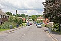
 Country road NE of Newent - geograph.org.uk - 834383.jpg 640 × 480; 160 KB
-
 Country road near Green Street - geograph.org.uk - 839649.jpg 480 × 640; 116 KB
-
 Country road to Upleadon - geograph.org.uk - 833703.jpg 640 × 480; 136 KB
-
 Countryside east of Llanbedrgoch - geograph.org.uk - 994919.jpg 640 × 480; 37 KB
-
 Countryside near Finlaystone - geograph.org.uk - 842494.jpg 640 × 480; 100 KB
-
 Cracked Peat - geograph.org.uk - 833725.jpg 640 × 480; 133 KB
-
 Crag on the slopes of Creag a' Mhill - geograph.org.uk - 833824.jpg 640 × 480; 116 KB
-
 Cramond Road South - geograph.org.uk - 840925.jpg 640 × 480; 114 KB
-

-
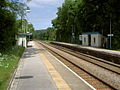
 Crossflatts Station - geograph.org.uk - 835078.jpg 640 × 480; 71 KB
-
 Cumbria Way by Stonethwaite Beck - geograph.org.uk - 878701.jpg 640 × 480; 110 KB
-

-

-
 Cwm Anafon - geograph.org.uk - 836699.jpg 640 × 480; 99 KB
-
 Cycle Lockers - Crossflatts Station - geograph.org.uk - 835082.jpg 640 × 444; 64 KB
-
 Damart Mills - Bingley - geograph.org.uk - 835137.jpg 640 × 486; 56 KB
-

-

-
 Descending Chno Dearg - geograph.org.uk - 837079.jpg 640 × 480; 79 KB
-
 Descent from Sron Mhor - geograph.org.uk - 845142.jpg 640 × 480; 103 KB
-
-

-
 Dinos Cafe Woodhall.jpg 640 × 438; 84 KB
-

-
 Dock Tarn - geograph.org.uk - 878660.jpg 640 × 480; 61 KB
-

-
 Docklands Minibuses.jpg 3,648 × 2,736; 4.39 MB
-
 Drain into the Gladhouse Reservoir - geograph.org.uk - 834155.jpg 480 × 640; 96 KB
-
 Duke Street - geograph.org.uk - 834497.jpg 640 × 475; 94 KB
-
 Dun an Sticer, North Uist - geograph.org.uk - 845837.jpg 640 × 360; 50 KB
-
 Dunstall Railway Arches - geograph.org.uk - 833543.jpg 640 × 480; 82 KB
-
 Durley Manor Farm buildings - geograph.org.uk - 842926.jpg 640 × 427; 119 KB
-
 Dusty track to Okle Clifford - geograph.org.uk - 833697.jpg 480 × 640; 231 KB
-
 Duxford Lodge Hotel - geograph.org.uk - 898365.jpg 640 × 480; 77 KB
-
 Eagle and Child, Staveley - geograph.org.uk - 1021662.jpg 640 × 480; 177 KB
-
 East coast of Sandray - geograph.org.uk - 1497646.jpg 640 × 480; 88 KB
-
 East Hook Farm and B-B - geograph.org.uk - 833531.jpg 640 × 480; 62 KB
-
-

-
 East Morton Golf Course - Carr Lane - geograph.org.uk - 834844.jpg 640 × 480; 109 KB
-

-
 East side of High Tove - geograph.org.uk - 878613.jpg 640 × 480; 32 KB
-
 Eastern end of Loch Beoraid - geograph.org.uk - 856039.jpg 640 × 480; 83 KB
-
 Eastern slopes of Glas-charn - geograph.org.uk - 856060.jpg 640 × 480; 72 KB
-
 Eastloch roadend - geograph.org.uk - 834537.jpg 640 × 480; 85 KB
-
 Elderflower by the gate - geograph.org.uk - 841073.jpg 640 × 480; 165 KB


_-_geograph.org.uk_-_938834.jpg)


_-_geograph.org.uk_-_846851.jpg)


_-_Main_Road_-_geograph.org.uk_-_834869.jpg)


