Category:United Kingdom photographs taken on 2009-05-31
Countries of Europe: Austria · Belarus · Belgium · Bosnia and Herzegovina · Czech Republic · Denmark · Estonia · Finland · France‡ · Georgia‡ · Germany · Greece · Hungary · Republic of Ireland · Italy · Latvia · Malta · Netherlands‡ · Norway · Poland · Portugal‡ · Romania · Russia‡ · Slovenia · Spain‡ · Sweden · Switzerland · Turkey‡ · Ukraine · United Kingdom
‡: partly located in Europe
‡: partly located in Europe
| ← | 31 May 2009 | → | ||
| ← | May 2009 | → | ||

United Kingdom photographs taken on 31 May 2009.
Image files should be categorized here automatically using {{taken on}} template. Direct categorisation is also possible, if automatic is impossible.
Subcategories
This category has only the following subcategory.
K
Media in category "United Kingdom photographs taken on 2009-05-31"
The following 200 files are in this category, out of 1,743 total.
(previous page) (next page)-
 "Postbox" in Reservoir Lane - geograph.org.uk - 1330243.jpg 640 × 480; 123 KB
-
 'Baron of Beef' pub - geograph.org.uk - 1336170.jpg 480 × 640; 138 KB
-
 'Dundarg' at Bangor - geograph.org.uk - 1334376.jpg 476 × 640; 429 KB
-
 'Havilah' at Bangor - geograph.org.uk - 1334437.jpg 560 × 640; 332 KB
-
 'Old Orleans' pub - geograph.org.uk - 1335153.jpg 480 × 640; 202 KB
-
 'The Anchor' - geograph.org.uk - 1335171.jpg 480 × 640; 146 KB
-
 'The Anchor' from a bridge over the Cam - geograph.org.uk - 1335173.jpg 640 × 480; 121 KB
-
 'The Castle' pub - geograph.org.uk - 1333098.jpg 640 × 480; 139 KB
-
 'The Fountain' bar - geograph.org.uk - 1333272.jpg 480 × 640; 88 KB
-
 'The Mitre' pub - geograph.org.uk - 1336181.jpg 640 × 480; 151 KB
-
 (0985) Carnation Tortrix (Cacoecimorpha pronubana) (3587603079).jpg 1,500 × 1,004; 1.27 MB
-
 162 -164 Kirkgate - geograph.org.uk - 1337416.jpg 640 × 480; 300 KB
-
 2009 Dickens Festival, Rochester - geograph.org.uk - 1339621.jpg 640 × 480; 121 KB
-
 2009 Dickens Festival, Rochester - geograph.org.uk - 1339650.jpg 640 × 480; 95 KB
-
 52.006 BF375 White-barred Clearwing, Synanthedon spheciformis (3580551373).jpg 3,524 × 2,672; 3.45 MB
-

-
 A cottage near the church - geograph.org.uk - 1332317.jpg 640 × 427; 367 KB
-
 A cricket match on Parker's Piece - geograph.org.uk - 1333315.jpg 640 × 480; 164 KB
-
 A deer exiting a pool on Meall Voirlich - geograph.org.uk - 1340082.jpg 640 × 454; 140 KB
-
 A Footbridge over The great West Road in Brentford - panoramio.jpg 3,072 × 2,304; 2.73 MB
-

-
 A lochan at the head of Glen Liver - geograph.org.uk - 1340840.jpg 640 × 427; 134 KB
-
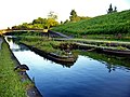
 A Mirror Image at Millbuies - geograph.org.uk - 1346854.jpg 640 × 480; 134 KB
-

-
 A red deer calf in Glen Liver - geograph.org.uk - 1340070.jpg 640 × 427; 133 KB
-
 A sign at Inverawe Forest car park - geograph.org.uk - 1342535.jpg 382 × 640; 129 KB
-
 A small burn in Glen Liver - geograph.org.uk - 1335500.jpg 427 × 640; 114 KB
-
 A small dam at the head of Glen Liver - geograph.org.uk - 1335470.jpg 640 × 427; 112 KB
-
 A small footpath leading to Claxton - geograph.org.uk - 1336350.jpg 640 × 480; 54 KB
-
 A small gully at Coire Raonuill - geograph.org.uk - 1334737.jpg 640 × 427; 146 KB
-
 A small lochan by Meall Voirlich - geograph.org.uk - 1340093.jpg 640 × 427; 152 KB
-
 A small tree in Glen Liver - geograph.org.uk - 1334742.jpg 427 × 640; 105 KB
-
 A stand of Willow trees near Barnwell - geograph.org.uk - 1339864.jpg 640 × 480; 104 KB
-
 A steep hillside in Glen Liver - geograph.org.uk - 1334744.jpg 640 × 427; 145 KB
-
 A Sunlit Tree at Millbuies - geograph.org.uk - 1346612.jpg 480 × 640; 150 KB
-
 A track by Loch Etive - geograph.org.uk - 1342049.jpg 640 × 427; 135 KB
-
 A Track by the Loch - geograph.org.uk - 1347085.jpg 640 × 480; 159 KB
-

-
 A tree in Glen Liver - geograph.org.uk - 1340338.jpg 427 × 640; 149 KB
-
 A Victim of the Storm - geograph.org.uk - 1347350.jpg 640 × 486; 151 KB
-
 A view towards North Hill - geograph.org.uk - 1335990.jpg 640 × 466; 90 KB
-
 A willow by Darwin College - geograph.org.uk - 1335166.jpg 640 × 480; 167 KB
-
 A1039 towards Flixton - geograph.org.uk - 1331060.jpg 640 × 480; 78 KB
-
-
 A41 Kings Langley Bypass - geograph.org.uk - 1340166.jpg 640 × 480; 83 KB
-
 A41 Langley Bypass - geograph.org.uk - 1345344.jpg 640 × 480; 109 KB
-
 Aa oneworld b777-200er n791an arp.jpg 2,205 × 1,597; 3.42 MB
-
 Abandoned Caravan, Aden - geograph.org.uk - 1334333.jpg 1,024 × 683; 139 KB
-

-
 Across the meadow to Oundle - geograph.org.uk - 1339926.jpg 640 × 480; 102 KB
-
 Adlingfleet Old Smithy - geograph.org.uk - 1330465.jpg 640 × 480; 88 KB
-
 Adlingfleet Old Tythe Barn - geograph.org.uk - 1330514.jpg 640 × 480; 122 KB
-

-
 Aer lingus a320-200 ei-deg lands london heathrow arp.jpg 1,600 × 1,045; 1.3 MB
-
 Aer lingus a320-200 ei-deg nosewheel arp.jpg 1,467 × 1,088; 1.31 MB
-
 Afon Fwy - geograph.org.uk - 1331091.jpg 640 × 533; 188 KB
-
 Afon Fwy - geograph.org.uk - 1572694.jpg 640 × 480; 158 KB
-
 Afon Fwy - geograph.org.uk - 1572695.jpg 480 × 640; 112 KB
-
 Afon Lledr at Roman Bridge - geograph.org.uk - 1334677.jpg 600 × 450; 160 KB
-
 Afon Llugwy at Capel Curig - geograph.org.uk - 1335203.jpg 600 × 450; 156 KB
-
 Air seychelles b767-300er s7-asy takeoff arp.jpg 2,808 × 1,897; 4 MB
-

-
 All fallen down - geograph.org.uk - 1345377.jpg 640 × 480; 125 KB
-
 All quiet for 65 years - geograph.org.uk - 1353301.jpg 640 × 480; 271 KB
-
 Allt Coire a' Chuil Droma Bhig - geograph.org.uk - 1330488.jpg 640 × 480; 252 KB
-
 Allt na Criachain - geograph.org.uk - 1336537.jpg 640 × 480; 186 KB
-
 An Dubh-sgeir - geograph.org.uk - 1700281.jpg 2,230 × 2,081; 1.4 MB
-
 An erratic boulder on Meall Voirlich - geograph.org.uk - 1335460.jpg 640 × 427; 137 KB
-
 An Island in the Loch - geograph.org.uk - 1347293.jpg 640 × 477; 97 KB
-

-
 An outcrop on Meall Inbhir - geograph.org.uk - 1340843.jpg 640 × 427; 137 KB
-
 An outcrop on Meall Voirlich - geograph.org.uk - 1340076.jpg 640 × 427; 146 KB
-
 An Stac Whiten Head - geograph.org.uk - 1700317.jpg 2,714 × 2,035; 1.86 MB
-

-
 An unnamed lochan by Meall Voirlich - geograph.org.uk - 1340828.jpg 640 × 427; 156 KB
-
 Anchor (3661090248).jpg 1,200 × 900; 267 KB
-
 And another^ - geograph.org.uk - 1334216.jpg 640 × 480; 70 KB
-

-
 Anglezarke Reservoir - geograph.org.uk - 1331348.jpg 640 × 480; 137 KB
-
 Anlaby House.jpg 640 × 405; 181 KB
-
 Anti Tank Coffin - geograph.org.uk - 1329926.jpg 480 × 640; 137 KB
-
 Apartments - geograph.org.uk - 1334012.jpg 640 × 457; 226 KB
-

-
 Approaching Claxton Corner - geograph.org.uk - 1330167.jpg 640 × 480; 106 KB
-
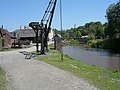
 Approaching Lowood Bridge - geograph.org.uk - 1347265.jpg 640 × 422; 101 KB
-

-

-
 Ardno House from the estate road - geograph.org.uk - 1330249.jpg 640 × 480; 96 KB
-
 Asylum Road Peckham - geograph.org.uk - 1330041.jpg 640 × 480; 99 KB
-
 Asylum Tavern, Peckham - geograph.org.uk - 1330018.jpg 640 × 480; 76 KB
-
 Attractive flint house on Church Lane - geograph.org.uk - 1329921.jpg 640 × 508; 112 KB
-
 Auchenlarie Bay - geograph.org.uk - 1362254.jpg 640 × 480; 103 KB
-
 Auchenlarie Bay - geograph.org.uk - 1362256.jpg 640 × 480; 64 KB
-
 Auchenlarie Beach - geograph.org.uk - 1362250.jpg 640 × 480; 66 KB
-
 B and B on Coxhill Road, Shepherdswell - geograph.org.uk - 1532490.jpg 640 × 480; 126 KB
-
 Baile Lòin - geograph.org.uk - 1341226.jpg 640 × 480; 275 KB
-
 Bala Lake from Castell Carndochan - geograph.org.uk - 1572879.jpg 640 × 480; 53 KB
-
 Bala Lake railway at Llanuwchllyn - geograph.org.uk - 1572895.jpg 480 × 640; 98 KB
-
 Balmavicar - geograph.org.uk - 1430550.jpg 640 × 428; 102 KB
-
 Balmavicar - geograph.org.uk - 1430553.jpg 640 × 428; 91 KB
-
 Balmavicar - geograph.org.uk - 1430562.jpg 640 × 428; 98 KB
-
 Banagher - geograph.org.uk - 1399472.jpg 640 × 480; 51 KB
-
 Bangor Marina - geograph.org.uk - 1334282.jpg 640 × 503; 393 KB
-

-

-
 Barnby Dun Bridge - geograph.org.uk - 1329451.jpg 640 × 480; 53 KB
-
 Barnwell road bridge - geograph.org.uk - 1340176.jpg 640 × 480; 135 KB
-
 Barpa Charavat - geograph.org.uk - 1341754.jpg 640 × 383; 227 KB
-
 Barpa Charavat - geograph.org.uk - 1341759.jpg 640 × 427; 288 KB
-
 Barpa Charavat - geograph.org.uk - 1341764.jpg 640 × 427; 235 KB
-
 Barpa Charavat - geograph.org.uk - 1341769.jpg 640 × 427; 236 KB
-
 Barpa Charavat - geograph.org.uk - 1341770.jpg 640 × 388; 181 KB
-
 Barpa Langass - geograph.org.uk - 1342027.jpg 640 × 427; 233 KB
-
 Barpa Langass - geograph.org.uk - 1342081.jpg 640 × 427; 241 KB
-
 Barton Haven - geograph.org.uk - 1332225.jpg 640 × 499; 82 KB
-
 Battle of Cairninis - geograph.org.uk - 1341853.jpg 640 × 427; 244 KB
-
 Beach south of Felixstowe Ferry - geograph.org.uk - 1329831.jpg 640 × 480; 70 KB
-
 Beal Sands - geograph.org.uk - 1332690.jpg 640 × 480; 46 KB
-
 Beauchamp Arms public house - geograph.org.uk - 1336364.jpg 640 × 480; 78 KB
-
 Beech trees above Prestbury - geograph.org.uk - 1335485.jpg 640 × 426; 127 KB
-
 Beinn Chreagach Summit - geograph.org.uk - 1347726.jpg 640 × 480; 96 KB
-
 Bell Tower - geograph.org.uk - 1339262.jpg 428 × 639; 65 KB
-
 Bell, Lacock school - geograph.org.uk - 1346255.jpg 640 × 519; 96 KB
-
 Bent Belisha Beacon - geograph.org.uk - 1329790.jpg 640 × 543; 161 KB
-
 Beware of leaning trunk - geograph.org.uk - 1330092.jpg 480 × 640; 115 KB
-
 Bharlais - geograph.org.uk - 1341280.jpg 520 × 640; 319 KB
-
 Bharlais - geograph.org.uk - 1341296.jpg 640 × 480; 298 KB
-
 Birkenside - geograph.org.uk - 1329848.jpg 640 × 346; 64 KB
-
 Birmingham Canal - panoramio (13).jpg 2,816 × 2,112; 2.08 MB
-
 Birmingham Canal - panoramio (14).jpg 2,816 × 2,112; 2.79 MB
-
 Birmingham Canal - panoramio (18).jpg 2,816 × 2,112; 2.3 MB
-
 Birmingham Canal - panoramio (19).jpg 2,816 × 2,112; 2.36 MB
-
 Birmingham Canal - panoramio (20).jpg 2,816 × 2,112; 2.28 MB
-
 Birmingham Canal - panoramio (21).jpg 2,816 × 2,112; 2.13 MB
-
 Birmingham Canal - panoramio (23).jpg 2,816 × 2,112; 2.29 MB
-
 Birmingham Canal - panoramio (24).jpg 2,816 × 2,112; 2.8 MB
-
 Birmingham, UK - panoramio (4).jpg 2,816 × 2,112; 2.27 MB
-
 Black House - geograph.org.uk - 1341718.jpg 640 × 442; 232 KB
-
 Blaenau Dolwyddelan, pasture land - geograph.org.uk - 1334700.jpg 600 × 450; 184 KB
-

-
 Blists Hill Museum - panoramio - PJMarriott (1).jpg 3,072 × 2,304; 1.2 MB
-
 Blists Hill Museum - panoramio - PJMarriott (2).jpg 3,072 × 2,304; 1.1 MB
-
 Blists Hill Museum - panoramio - PJMarriott.jpg 3,072 × 2,304; 2.02 MB
-
 Blists Hill Museum - panoramio.jpg 3,072 × 2,304; 1.35 MB
-
 Blois Hall Farm - geograph.org.uk - 1330984.jpg 640 × 314; 52 KB
-

-
 Boathouse - geograph.org.uk - 1341473.jpg 640 × 361; 211 KB
-
 Boats on Loch Poit na h-I - geograph.org.uk - 1373155.jpg 640 × 427; 52 KB
-
 Boggy hollow - geograph.org.uk - 1359358.jpg 640 × 480; 89 KB
-
 Boggy Pool - geograph.org.uk - 1340966.jpg 640 × 480; 311 KB
-
 Bolton Barn Farm - geograph.org.uk - 1342752.jpg 640 × 480; 105 KB
-
 Bolton Barn Farm - geograph.org.uk - 1342761.jpg 640 × 480; 84 KB
-
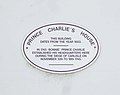 Bonnie Prince Charlie plaque - geograph.org.uk - 1363931.jpg 640 × 506; 36 KB
-
 Boots Chemist, Sidney Street - geograph.org.uk - 1333661.jpg 640 × 480; 138 KB
-
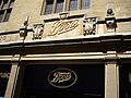
 Boots, Dispensing Chemists - geograph.org.uk - 1341573.jpg 480 × 640; 154 KB
-
 Boulders in Glen Liver - geograph.org.uk - 1418983.jpg 640 × 427; 152 KB
-
 Boulders in Glen Liver - geograph.org.uk - 1419000.jpg 640 × 427; 133 KB
-
 Bournefield Farm - geograph.org.uk - 1331788.jpg 640 × 426; 167 KB
-
 Bouverie Street - geograph.org.uk - 1331827.jpg 640 × 457; 315 KB
-
 Bouverie Street - geograph.org.uk - 1331833.jpg 640 × 457; 290 KB
-
 Bouverie Street - geograph.org.uk - 1331844.jpg 640 × 457; 313 KB
-
 Bouverie Street - geograph.org.uk - 1332448.jpg 640 × 457; 282 KB
-

-
 Bowdenmoor Farm - geograph.org.uk - 1338928.jpg 640 × 426; 95 KB
-
 Bowdenmoor Reservoir - geograph.org.uk - 1338920.jpg 640 × 466; 92 KB
-
 Letter box on Union Road - geograph.org.uk - 1331782.jpg 426 × 640; 231 KB
-
 Bradfield College - geograph.org.uk - 1331687.jpg 640 × 427; 181 KB
-
 Bradfield College - geograph.org.uk - 1331691.jpg 640 × 426; 202 KB
-
 Brampton - geograph.org.uk - 1363935.jpg 640 × 480; 63 KB
-
 Brampton - geograph.org.uk - 1363947.jpg 640 × 489; 71 KB
-

-
 Brass studs in pavement of Bridge Street - geograph.org.uk - 1336113.jpg 640 × 480; 122 KB
-
 Brean Down from Uphill. - panoramio.jpg 2,112 × 2,816; 2.52 MB
-
 Brent Knoll. - panoramio.jpg 2,816 × 2,112; 2.74 MB
-
 Bridge and Track - geograph.org.uk - 1341274.jpg 450 × 600; 96 KB
-

-
 Bridge Inn, Santon Bridge - geograph.org.uk - 1329812.jpg 600 × 450; 95 KB
-
 Bridge over Kirk Burn - geograph.org.uk - 1334751.jpg 640 × 480; 144 KB
-
 Bridge over Pollagach Burn - geograph.org.uk - 1341398.jpg 450 × 600; 91 KB
-
 Bridge over the Afon Wybrnant, Ty Mawr - geograph.org.uk - 1335744.jpg 600 × 450; 241 KB
-
 Bridge over the Allt Calder - geograph.org.uk - 1339223.jpg 640 × 480; 101 KB
-
 Bridge over the Allt Calder - geograph.org.uk - 1339226.jpg 640 × 480; 110 KB
-
 Bridge over the Allt Fionnach - geograph.org.uk - 1339246.jpg 640 × 480; 93 KB
-
 Bridge over the Cam - geograph.org.uk - 1335156.jpg 640 × 480; 144 KB
-

-
 Bridge over the Loch - geograph.org.uk - 1347220.jpg 640 × 480; 140 KB
-
 Bridge over the River Findhorn - geograph.org.uk - 1339383.jpg 640 × 480; 127 KB
-
 Bridge Street - geograph.org.uk - 1335312.jpg 640 × 457; 340 KB
-
 Bridge Street - geograph.org.uk - 1335321.jpg 640 × 457; 345 KB
-
 Bridge Street - geograph.org.uk - 1335323.jpg 640 × 457; 363 KB
-
 Bridge Street Row West - geograph.org.uk - 1335317.jpg 640 × 457; 303 KB
-
 Bridge Street Row West - geograph.org.uk - 1335325.jpg 640 × 457; 309 KB
-
 Bridge Street Row West - geograph.org.uk - 1335328.jpg 640 × 457; 315 KB
-
 Bridge Street Row West - geograph.org.uk - 1335334.jpg 640 × 457; 267 KB
-
 Bridge Street, Cambridge - geograph.org.uk - 1336203.jpg 640 × 480; 142 KB
-
 Bridleway junction - geograph.org.uk - 1341212.jpg 640 × 427; 142 KB
-
 Bridleway to Claxton - geograph.org.uk - 1330055.jpg 640 × 480; 129 KB
-
 Bridleway to Flecknoe (1) - geograph.org.uk - 1331228.jpg 640 × 426; 88 KB
-
 Bridleway to Flecknoe (2) - geograph.org.uk - 1331232.jpg 640 × 426; 114 KB
-
 Bridleway to Flecknoe (3) - geograph.org.uk - 1331237.jpg 640 × 408; 116 KB


_Carnation_Tortrix_(Cacoecimorpha_pronubana)_(3587603079).jpg)


.jpg)


.jpg)
.jpg)
.jpg)
.jpg)
.jpg)
.jpg)
.jpg)
.jpg)
.jpg)


.jpg)
.jpg)


_-_geograph.org.uk_-_1331228.jpg)
_-_geograph.org.uk_-_1331232.jpg)
_-_geograph.org.uk_-_1331237.jpg)
.jpg)