File:(Map showing neutral zones between Saudi Arabia and Iraq and between Saudi Arabia and Kuwait). LOC 91682276.jpg

Size of this preview: 699 × 600 pixels. Other resolutions: 280 × 240 pixels | 560 × 480 pixels | 895 × 768 pixels | 1,194 × 1,024 pixels | 2,388 × 2,048 pixels | 7,757 × 6,654 pixels.
Original file (7,757 × 6,654 pixels, file size: 4.48 MB, MIME type: image/jpeg)
Captions
Captions
Add a one-line explanation of what this file represents
Summary edit
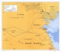
| Description |
English: "721438 (B01188) 3-91." Depths shown by gradient tints. Available also through the Library of Congress Web site as a raster image. DRM |
||
| Title | [Map showing neutral zones between Saudi Arabia and Iraq and between Saudi Arabia and Kuwait]. | ||
| Shelf ID | G7531.F2 1991 .U5 | ||
| Date | |||
| Source | https://www.loc.gov/item/91682276/ | ||
| Author | United States. Central Intelligence Agency | ||
| Permission (Reusing this file) |
|
||
| Other versions |
|
||
| Location | Kuwait · Saudi Arabia · Iraq | ||
| Part of | American Memory · General Maps · Catalog · Geography And Map Division | ||
| Subject | Boundaries · Maps · Saudi Arabia · Iraq · Kuwait |

._LOC_91682276.jpg&action=edit§ion=1)
Licensing edit
._LOC_91682276.jpg&action=edit§ion=2)
| This image is a work of a Central Intelligence Agency employee, taken or made as part of that person's official duties. As a Work of the United States Government, this image or media is in the public domain in the United States.
|

|
File history
Click on a date/time to view the file as it appeared at that time.
| Date/Time | Thumbnail | Dimensions | User | Comment | |
|---|---|---|---|---|---|
| current | 09:43, 11 June 2018 | | 7,757 × 6,654 (4.48 MB) | Fæ (talk | contribs) | LOC Maps https://www.loc.gov/item/91682276/ #11713 |
You cannot overwrite this file.
File usage on Commons
The following page uses this file:
File usage on other wikis
The following other wikis use this file:
- Usage on sh.wikipedia.org
._LOC_91682276.jpg&oldid=734037541)