File:(Survey of the original landholdings in Washington D.C. in the area bounded by The Mall, North Capitol St., Tiber Creek, N St. N.W., and Seventh St. N.W.) LOC 87694237.jpg

Size of this preview: 720 × 599 pixels. Other resolutions: 288 × 240 pixels | 577 × 480 pixels | 923 × 768 pixels | 1,230 × 1,024 pixels | 2,460 × 2,048 pixels | 8,283 × 6,896 pixels.
Original file (8,283 × 6,896 pixels, file size: 7.48 MB, MIME type: image/jpeg)
Captions
Captions
Add a one-line explanation of what this file represents
Summary edit
| Description |
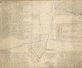
English: Cadastral map showing tracts dated 1687 thru 1794 of which 3 are named "Port Royal," "Gleanings," and "Youngsborough." "The annexed plat ... made by Order of the Hon. the Judges of the Circuit Court ... according to the instructions of Plaintiff's Counsels ..." Certified in ink by "Surveyors Office, 29th Nov. 1858." Pen-and-ink and watercolor. Includes text and statistical tables. Available also through the Library of Congress Web site as a raster image. Vault DCP |
||
| Title | [Survey of the original landholdings in Washington D.C. in the area bounded by The Mall, North Capitol St., Tiber Creek, N St. N.W., and Seventh St. N.W.] | ||
| Shelf ID | G3851.G46 1794 .C3 | ||
| Date | |||
| Source | https://www.loc.gov/item/87694237/ | ||
| Author | Carbery, Lewis; District Of Columbia. Office Of The Surveyor; United States. Court Of Appeals (District Of Columbia Circuit) | ||
| Permission (Reusing this file) |
|
||
| Other versions |
|
||
| Location | United States · Washington D.C. · District Of Columbia · Washington | ||
| Part of | American Memory · Catalog · County Landownership Maps · Geography And Map Division · Cultural Landscapes | ||
| Subject | Washington (D.C.) · Surveys · Maps, Manuscript · Washington · Land Grants · United States · Maps · Early Works To 1800 · District Of Columbia · Real Property |

_LOC_87694237.jpg&action=edit§ion=1)
Licensing edit
_LOC_87694237.jpg&action=edit§ion=2)
|
This is a faithful photographic reproduction of a two-dimensional, public domain work of art. The work of art itself is in the public domain for the following reason:
The official position taken by the Wikimedia Foundation is that "faithful reproductions of two-dimensional public domain works of art are public domain".
This photographic reproduction is therefore also considered to be in the public domain in the United States. In other jurisdictions, re-use of this content may be restricted; see Reuse of PD-Art photographs for details. | ||||
File history
Click on a date/time to view the file as it appeared at that time.
| Date/Time | Thumbnail | Dimensions | User | Comment | |
|---|---|---|---|---|---|
| current | 02:31, 7 June 2018 | | 8,283 × 6,896 (7.48 MB) | Fæ (talk | contribs) | LOC Maps https://www.loc.gov/item/87694237/ #22316 |
You cannot overwrite this file.
File usage on Commons
The following page uses this file:
_LOC_87694237.jpg&oldid=734375663)