File:1608 Grafschaft Mark, Grafschaft Limburg.png

Size of this preview: 800 × 540 pixels. Other resolutions: 320 × 216 pixels | 640 × 432 pixels | 1,109 × 749 pixels.
Original file (1,109 × 749 pixels, file size: 1.83 MB, MIME type: image/png)
Captions
Captions
Add a one-line explanation of what this file represents
Summary edit
| Description |
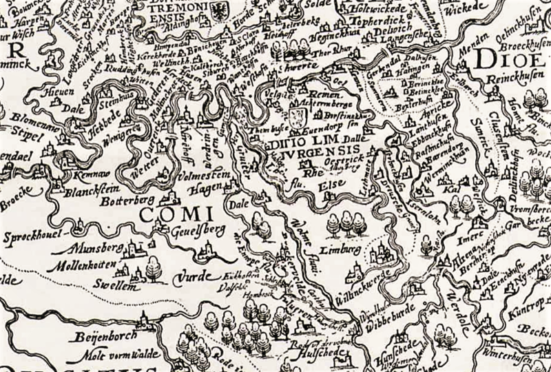
Deutsch: Grafschaft Mark, Kartenausschnitt der Territorialkarte „Nova comitatus Marckensis tabula“, 1608. Beschreibung: „3 Meilen = 7,4 cm – 20,5 x 30 – Kopie nach Druck – Detmar Mulher“. In der Kartenmitte Hagen mit Umgebung und die Grafschaft Limburg. |
| Date | |
| Source | Landesarchiv NRW Abteilung Westfalen, DFG-Viewer, Kartensammlung A Nr. 21235 |
| Author | Detmar Mulher (1567–1633) |
Licensing edit
|
This work is in the public domain in its country of origin and other countries and areas where the copyright term is the author's life plus 100 years or fewer. This work is in the public domain in the United States because it was published (or registered with the U.S. Copyright Office) before January 1, 1929. | |
| This file has been identified as being free of known restrictions under copyright law, including all related and neighboring rights. | |
File history
Click on a date/time to view the file as it appeared at that time.
| Date/Time | Thumbnail | Dimensions | User | Comment | |
|---|---|---|---|---|---|
| current | 12:06, 13 April 2019 | | 1,109 × 749 (1.83 MB) | Bärwinkel,Klaus (talk | contribs) | {{Information |Description={{de|1=Grafschaft Mark, Territorialkarte „Nova comitatus Marckensis tabula“, 1608. Beschreibung: „3 Meilen = 7,4 cm – 20,5 x 30 – Kopie nach Druck – Detmar Mulher“.}} |Source=Landesarchiv NRW Abteilung Westfalen, DFG-Viewer, Kartensammlung A Nr. 21235 |Date=1608 |Author=Detmar Mulher |Permission= |other_versions= }} == {{int:license}} == {{free screenshot|license={{GPL}} }} Category:History of Hagen Category:History of Hohenlimburg |
You cannot overwrite this file.
File usage on Commons
There are no pages that use this file.