File:1770 Karte Bauerschaft Hengstey, Haus Niedernhofen.png

Size of this preview: 754 × 600 pixels. Other resolutions: 302 × 240 pixels | 604 × 480 pixels | 923 × 734 pixels.
Original file (923 × 734 pixels, file size: 1.33 MB, MIME type: image/png)
Captions
Captions
Add a one-line explanation of what this file represents
Summary edit
| Description |
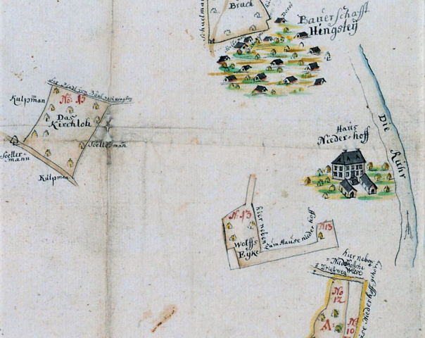
Deutsch: Ausschnitt aus der Karte „Vermessung und Teilung der Boeler Mark“ von 1770 mit Ansicht der Bauerschaft Hengstey und Haus Niedernhofen an der Ruhr. Der Adelssitz derer von Ovelacker hatte eine Größe von 169 Hektar. |
| Date | |
| Source | Landesarchiv NRW Abteilung Westfalen, DFG-Viewer, Kartensammlung A, Nr.7386 – DFG-Viewer |
| Author | Johann Heinrich Merner |
Licensing edit
|
This work is in the public domain in its country of origin and other countries and areas where the copyright term is the author's life plus 100 years or fewer. This work is in the public domain in the United States because it was published (or registered with the U.S. Copyright Office) before January 1, 1929. | |
| This file has been identified as being free of known restrictions under copyright law, including all related and neighboring rights. | |
File history
Click on a date/time to view the file as it appeared at that time.
| Date/Time | Thumbnail | Dimensions | User | Comment | |
|---|---|---|---|---|---|
| current | 09:38, 1 October 2021 | | 923 × 734 (1.33 MB) | Bärwinkel,Klaus (talk | contribs) | Veränderte Version der Datei. Selbst bearbeitet am 1.10.2021 ~~~~ |
| 12:45, 5 January 2021 |  | 929 × 686 (1.13 MB) | Bärwinkel,Klaus (talk | contribs) | {{Information |Description={{de|1=Ausscnitt aus der Karte „Boeler Markenteilung“ von 1770 mit der Ansicht der Bauerschaft Hengstey und Haus Niedernhofen.}} |Source=Landesarchiv NRW Abteilung Westfalen, DFG-Viewer, Kartensammlung A, Nr.7386 |Date=1770 |Author=Johann Heinrich Merner |Permission= |other_versions= }} Category:Hengstey |
You cannot overwrite this file.
File usage on Commons
There are no pages that use this file.
File usage on other wikis
The following other wikis use this file:
- Usage on de.wikipedia.org