File:1902 Elsey, Gemeindegrenzen.jpg

Size of this preview: 800 × 598 pixels. Other resolutions: 320 × 239 pixels | 640 × 479 pixels | 1,024 × 766 pixels | 1,151 × 861 pixels.
Original file (1,151 × 861 pixels, file size: 539 KB, MIME type: image/jpeg)
Captions
Captions
Add a one-line explanation of what this file represents
Summary edit
| Description |
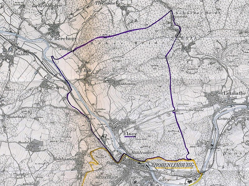
Deutsch: Eingezeichnete Gemeindegrenzen von Elsey, 1902 vor der Vereinigung mit Hohenlimburg. 1 : 25.000, 44 x 46 cm. Regierung Arnsberg Nr. 17779. |
| Date | |
| Source | Landesarchiv NRW Abteilung Westfalen, DFG-Viewer, Kartensammlung A Nr. 1607. |
| Author | Regierung Arnsberg |
Licensing edit
|
This work is in the public domain in its country of origin and other countries and areas where the copyright term is the author's life plus 100 years or fewer. This work is in the public domain in the United States because it was published (or registered with the U.S. Copyright Office) before January 1, 1929. | |
| This file has been identified as being free of known restrictions under copyright law, including all related and neighboring rights. | |
File history
Click on a date/time to view the file as it appeared at that time.
| Date/Time | Thumbnail | Dimensions | User | Comment | |
|---|---|---|---|---|---|
| current | 15:15, 7 January 2021 | | 1,151 × 861 (539 KB) | Bärwinkel,Klaus (talk | contribs) | {{Information |Description={{de|1=Eingezeichnete Gemeindegrenzen von Elsey, 1902. 1 : 25.000, 44 x 46 cm. Regierung Arnsberg Nr. 17779.}} |Source=Landesarchiv NRW Abteilung Westfalen, DFG-Viewer, Kartensammlung A Nr. 1607. |Date=1902 |Author=Regierung Arnsberg |Permission= |other_versions= }} == {{int:license}} == {{free screenshot|license={{GPL}} }} Category:Elsey (Hagen) Category:Maps of Hagen |
You cannot overwrite this file.
File usage on Commons
There are no pages that use this file.
File usage on other wikis
The following other wikis use this file:
- Usage on de.wikipedia.org