File:2016 Freedom House world map.png
Size of this preview: 800 × 405 pixels. Other resolutions: 320 × 162 pixels | 640 × 324 pixels | 1,024 × 518 pixels | 1,280 × 648 pixels | 2,560 × 1,296 pixels | 4,972 × 2,517 pixels.
Original file (4,972 × 2,517 pixels, file size: 361 KB, MIME type: image/png)
Captions
Captions
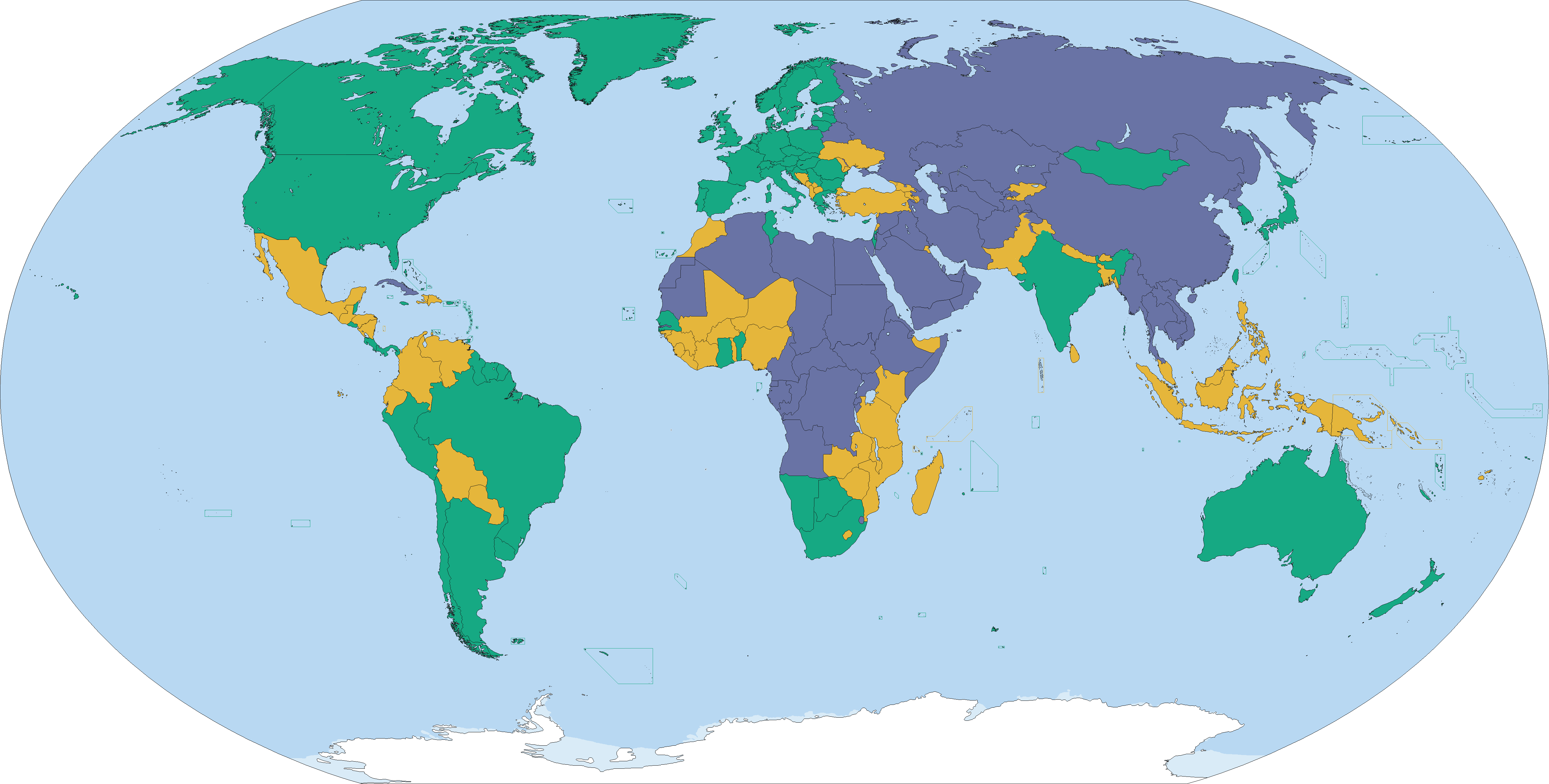
Country ratings from Freedom House's Freedom in the World 2016 survey, concerning the state of world freedom in 2015.[1]
Summary
| Description |
English: Country ratings from Freedom House's Freedom in the World 2016 survey, concerning the state of world freedom in 2015.[1]
Free (86) Partly Free (59) Not Free (50) See also: File:2015 Freedom House world map.png, File:2013_Freedom_House_world_map.svg |
| Date | |
| Source | Own work |
| Author | Abrahamic Faiths |
Licensing
I, the copyright holder of this work, hereby publish it under the following license:
This file is licensed under the Creative Commons Attribution-Share Alike 4.0 International license.
- You are free:
- to share – to copy, distribute and transmit the work
- to remix – to adapt the work
- Under the following conditions:
- attribution – You must give appropriate credit, provide a link to the license, and indicate if changes were made. You may do so in any reasonable manner, but not in any way that suggests the licensor endorses you or your use.
- share alike – If you remix, transform, or build upon the material, you must distribute your contributions under the same or compatible license as the original.
- ↑ https://freedomhouse.org/sites/default/files/FH_FITW_Report_2016.pdf Freedom in the World 2016], Freedom House. Retrieved 28 January 2016.
File history
Click on a date/time to view the file as it appeared at that time.
| Date/Time | Thumbnail | Dimensions | User | Comment | |
|---|---|---|---|---|---|
| current | 18:25, 4 May 2016 | | 4,972 × 2,517 (361 KB) | VulpesVulpes42 (talk | contribs) | Fixed some island borders. |
| 18:42, 20 April 2016 |  | 4,972 × 2,517 (361 KB) | VulpesVulpes42 (talk | contribs) | Fixed three pixels in Somaliland that were brighter for no reason, as well as an area in Ethiopia that was darker for no reason. | |
| 18:39, 9 April 2016 |  | 4,972 × 2,517 (361 KB) | VulpesVulpes42 (talk | contribs) | Isn't it weird how doing the exact same thing using gimp doesn't double the file size? | |
| 18:14, 9 April 2016 |  | 4,972 × 2,517 (361 KB) | VulpesVulpes42 (talk | contribs) | Reverted to version as of 10:02, 3 April 2016 (UTC) For some reason this file was much larger than the previous version. I expected it to become smaller. Maybe because I used paint. Lesson learned, always use gimp. | |
| 18:12, 9 April 2016 |  | 4,972 × 2,517 (622 KB) | VulpesVulpes42 (talk | contribs) | Fixed an area where the shade of green was darker and the shade of yellow lighter for no apparent reason. | |
| 10:02, 3 April 2016 |  | 4,972 × 2,517 (361 KB) | VulpesVulpes42 (talk | contribs) | Removed Tibet from the map. First off, why should this map show only Tibet but not the other autonomous regions? They have the same political status within the PRC. Secondly, as far as my understanding goes, this map should only show sovereign states,... | |
| 16:56, 27 March 2016 |  | 4,972 × 2,517 (382 KB) | Christian Ferrer (talk | contribs) | Reverted to version as of 08:54, 26 March 2016 (UTC) | |
| 15:33, 27 March 2016 |  | 4,972 × 2,517 (399 KB) | Insidema (talk | contribs) | Reverted to version as of 16:52, 25 March 2016 (UTC) | |
| 08:54, 26 March 2016 |  | 4,972 × 2,517 (382 KB) | Ankry (talk | contribs) | Reverted to version as of 16:39, 28 January 2016 (UTC) | |
| 16:52, 25 March 2016 |  | 4,972 × 2,517 (399 KB) | Hpyounes (talk | contribs) | Somaliland is not a sovereign State |
You cannot overwrite this file.
File usage on Commons
There are no pages that use this file.
File usage on other wikis
The following other wikis use this file:
- Usage on ar.wikipedia.org
- Usage on be-tarask.wikipedia.org
- Usage on bg.wikipedia.org
- Usage on ca.wikipedia.org
- Usage on de.wikipedia.org
- Usage on en.wikipedia.org
- Usage on fa.wikipedia.org
- Usage on fr.wikipedia.org
- Usage on gn.wikipedia.org
- Usage on gu.wikipedia.org
- Usage on hy.wikipedia.org
- Usage on id.wikipedia.org
- Usage on it.wikipedia.org
- Usage on ja.wikipedia.org
- Usage on ko.wikipedia.org
- Usage on pt.wikipedia.org
- Usage on ru.wikipedia.org
- Usage on simple.wikipedia.org
- Usage on th.wikipedia.org
- Usage on uk.wikipedia.org
- Usage on zh.wikipedia.org