File:ASC Leiden - F. van der Kraaij Collection - 20 - 036 - L'île de Lété sur le fleuve Niger avec deux petites colonies - Frontière Niger-Bénin, 1972.tif

Size of this JPG preview of this TIF file: 800 × 533 pixels. Other resolutions: 320 × 213 pixels | 640 × 427 pixels | 1,024 × 683 pixels | 1,280 × 853 pixels | 2,560 × 1,706 pixels | 6,505 × 4,336 pixels.

Original file (6,505 × 4,336 pixels, file size: 80.75 MB, MIME type: image/tiff, 2 pages)
Captions
Captions
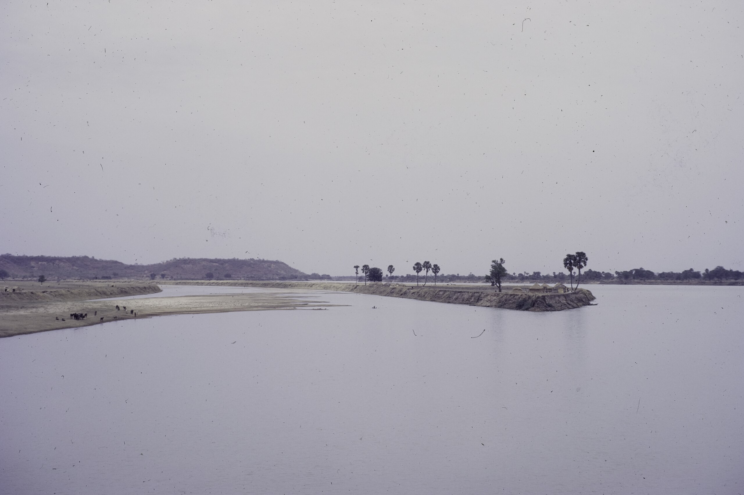
Lété Island in the Niger River with two tiny settlements on the Benin (then Dahomey)-Niger border, 1972.
Summary
edit| Photographer |
|
|||||||||||||||||||||||
| Description |
Nederlands: Lété-eiland in de rivier de Niger met twee kleine nederzettingen op de grens tussen Benin (toen Dahomey) en Niger. De betwiste eigendom van 24 riviereilanden in de rivier de Niger, die de grens vormt tussen Niger en Dahomey (omgedoopt tot Benin in 1975), leidde in 1963 bijna tot een oorlog tussen de twee landen kort na hun onafhankelijkheid in 1960. De foto toont een van deze eilanden en is gemaakt in 1972 bij het oversteken van de rivier tussen Gaya (Niger) en Malanville (Benin, voorheen Dahomey). We zien traditionele hutten op het eiland, een boot in de rivier en vee aan de oever van de rivier. Het geschil werd definitief beslecht in 2005 toen het Internationaal Gerechtshof 16 eilanden toekende aan Niger en negen aan Benin.
English: Lété Island in the Niger River with two tiny settlements on the Benin (then Dahomey)-Niger border. The disputed ownership of 24 riverine islands in the Niger River which forms the border between Niger and Dahomey (renamed Benin in 1975) triggered almost a war in 1963 between the two countries shortly after their 1960 independence. The photo shows one of these islands and was taken in 1972 when crossing the river between Gaya (Niger) and Malanville (Benin, formerly Dahomey). We see traditional huts on the island, a boat in the river, and cattle on the bank of the river. The dispute was definitely settled in 2005 when the International Court of Justice awarded 16 islands to Niger and nine to Benin.
Français : L'île de Lété sur le fleuve Niger avec deux petites colonies à la frontière entre le Bénin (alors Dahomey) et le Niger. La propriété contestée de 24 îles fluviales du fleuve Niger qui forme la frontière entre le Niger et le Dahomey (rebaptisé Bénin en 1975) a déclenché une quasi-guerre en 1963 entre les deux pays peu après leur indépendance en 1960. La photo montre l'une de ces îles et a été prise en 1972 lors de la traversée du fleuve entre Gaya (Niger) et Malanville (Bénin, ex Dahomey). Nous voyons des huttes traditionnelles sur l'île, un bateau dans la rivière et du bétail sur la rive de la rivière. Le différend a été définitivement réglé en 2005 lorsque la Cour internationale de justice a attribué 16 îles au Niger et neuf au Bénin. |
|||||||||||||||||||||||
| Depicted place |
Français : Frontière Niger / Bénin (ex-Dahomey) English: Border of Niger / Benin (formerly Dahomey) Nederlands: Grens van Niger / Benin (voorheen Dahomey) |
|||||||||||||||||||||||
| Date | 1972 | |||||||||||||||||||||||
| Source |
Fred van der Kraaij collection
|
|||||||||||||||||||||||


Licensing
editPhotographs of West Africa by the Dutch economist Fred P. M. van der Kraaij, donated to the African Studies Centre Leiden and Wikimedia Commons.
Fred P. M. van der Kraaij, the copyright holder of this work, hereby publishes it under the following licenses: This file is licensed under the Creative Commons Attribution-Share Alike 4.0 International license. Attribution: Fred P. M. van der Kraaij
You may select the license of your choice. |

File history
Click on a date/time to view the file as it appeared at that time.
| Date/Time | Thumbnail | Dimensions | User | Comment | |
|---|---|---|---|---|---|
| current | 18:01, 4 February 2022 |  | 6,505 × 4,336, 2 pages (80.75 MB) | Hansmuller (talk | contribs) | Uploaded a work by {{Creator:Fred van der Kraaij}} from Fred van der Kraaij collection{{Institution:African Studies Centre (Leiden)}} with UploadWizard |
You cannot overwrite this file.
File usage on Commons
The following 2 pages use this file:
File usage on other wikis
The following other wikis use this file:
- Usage on de.wikipedia.org
- Usage on fr.wikipedia.org
- Usage on hr.wikipedia.org