File:A Post-Medieval copper alloy buckle (FindID 186808).jpg

Size of this preview: 800 × 529 pixels. Other resolutions: 320 × 211 pixels | 640 × 423 pixels | 1,024 × 677 pixels | 1,280 × 846 pixels | 1,628 × 1,076 pixels.
Original file (1,628 × 1,076 pixels, file size: 450 KB, MIME type: image/jpeg)
Captions
Captions
Add a one-line explanation of what this file represents
Summary
edit.jpg&action=edit§ion=1)
| A Post-Medieval copper alloy buckle | |||
|---|---|---|---|
| Photographer |
Buckinghamshire County Council, Lynne Buckley, 2007-07-17 11:26:48 |
||
| Title |
A Post-Medieval copper alloy buckle |
||
| Description |
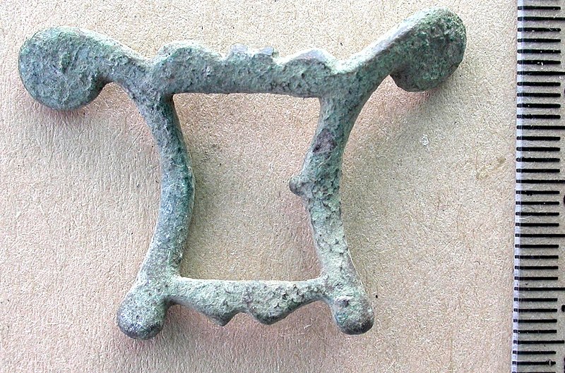
English: Post medieval cast trapezoidal double-looped buckle frame. The loops widen away form the strap bar and are symmetrical apart from their different outer sides. One has a cusped outer edge shaped into four rounded knops, two wider flanking two smaller, with very large projections from the corners. These projections curve away form the frame before ending in large circular terminals. The other loop has large rounded knops in the corners and the outer side is expanded in the centre into a pair of triangle points. The strap bar is narrowed and mostly missing to a break. The pin is also missing.
Whitehead (2003: 84) illustrates a similar example, no. 527, which he dates to c. AD 1620-1680. |
||
| Depicted place | (County of findspot) Buckinghamshire | ||
| Date | between 1620 and 1680 | ||
| Accession number |
FindID: 186808 Old ref: BUC-C98411 Filename: Dscn4543.jpg |
||
| Credit line |
|
||
| Source |
https://finds.org.uk/database/ajax/download/id/144243 Catalog: https://finds.org.uk/database/images/image/id/144243/recordtype/artefacts archive copy at the Wayback Machine Artefact: https://finds.org.uk/database/artefacts/record/id/186808 |
||
| Permission (Reusing this file) |
Attribution-ShareAlike License version 4.0 (verified 20 November 2020) | ||
| Object location | | View this and other nearby images on: OpenStreetMap |
|---|
.jpg¶ms=051.852100_N_-000.585910_E_globe:Earth_class:object_type:object__&language=en)
Licensing
edit.jpg&action=edit§ion=2)
This file is licensed under the Creative Commons Attribution-Share Alike 4.0 International license.
Attribution: The Portable Antiquities Scheme/ The Trustees of the British Museum
- You are free:
- to share – to copy, distribute and transmit the work
- to remix – to adapt the work
- Under the following conditions:
- attribution – You must give appropriate credit, provide a link to the license, and indicate if changes were made. You may do so in any reasonable manner, but not in any way that suggests the licensor endorses you or your use.
- share alike – If you remix, transform, or build upon the material, you must distribute your contributions under the same or compatible license as the original.
File history
Click on a date/time to view the file as it appeared at that time.
| Date/Time | Thumbnail | Dimensions | User | Comment | |
|---|---|---|---|---|---|
| current | 22:57, 26 January 2017 | | 1,628 × 1,076 (450 KB) | Fæ (talk | contribs) | Portable Antiquities Scheme, BUC, FindID: 186808, post medieval, page 540, batch count 1570 |
You cannot overwrite this file.
File usage on Commons
The following page uses this file:
.jpg)
.jpg&oldid=806827689)