File:A chart of Delaware Bay and River - from the original by Mr. Fisher of Philadelphia, 1776. NYPL1253194.tiff
Size of this JPG preview of this TIF file: 761 × 600 pixels. Other resolutions: 305 × 240 pixels | 609 × 480 pixels | 975 × 768 pixels | 1,280 × 1,009 pixels | 2,560 × 2,017 pixels | 4,945 × 3,897 pixels.
Original file (4,945 × 3,897 pixels, file size: 55.15 MB, MIME type: image/tiff)
Captions
Captions
Add a one-line explanation of what this file represents
Summary edit
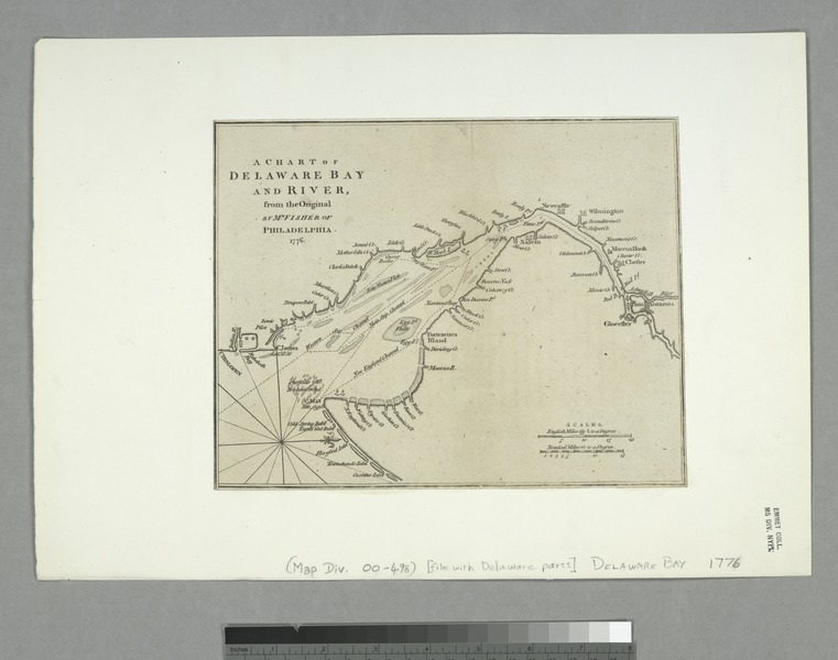
| Description | A chart of Delaware Bay and River / from the original by Mr. Fisher of Philadelphia, 1776.; Cartographic materials from the Emmet Collection of Manuscripts Etc. Relating to American History. | |||||||||||||||||||||||
| Notes | Copy in Map Div. 00-498: Emmet Collection. ''Note 2.'') Emmet Collection ; 3339. ''Note 3.'') From Gentleman's magazine, July 1779. ''Note 4.'') National Endowment for the Humanities Grant for Access to Early Maps of the Middle Atlantic Seaboard. ''Note 5.'') Oriented with north to the right. ''Note 6.'') Shows various ship channels from the mouth of Delaware Bay to Philadelphia. | |||||||||||||||||||||||
| Catalogue call number | Map Div. 00-498 [Filed with Delaware parts] | |||||||||||||||||||||||
| Standard reference | LC Maps of North America, 1750-1789, 1372; EM3339; Jolly, D.C. Maps of America in periodicals before 1800, 329 | |||||||||||||||||||||||
| Date | ||||||||||||||||||||||||
| Source |
http://digitalgallery.nypl.org/nypldigital/dgkeysearchdetail.cfm?imageID=1253194
|
|||||||||||||||||||||||
| Author | Fisher, Joshua, 1707-1783 -- Cartographer | |||||||||||||||||||||||
| Permission (Reusing this file) |
From The Lionel Pincus & Princess Firyal Map Division. http://maps.nypl.org
|
|||||||||||||||||||||||
| Location | Stephen A. Schwarzman Building / The Lionel Pincus and Princess Firyal Map Division | |||||||||||||||||||||||
| Digital item published | 12-30-2004; updated 3-25-2011 | |||||||||||||||||||||||
| Digital ID | 1253194 | |||||||||||||||||||||||

The making of this file was supported by Wikimedia UK.
To see other files made with the support of Wikimedia UK, please see the category Supported by Wikimedia UK.
|
File history
Click on a date/time to view the file as it appeared at that time.
| Date/Time | Thumbnail | Dimensions | User | Comment | |
|---|---|---|---|---|---|
| current | 07:30, 20 April 2014 |  | 4,945 × 3,897 (55.15 MB) | Fæ (talk | contribs) | GWToolset:: Creating mediafile for Fæ. Tranche 2.229 |
You cannot overwrite this file.
File usage on Commons
There are no pages that use this file.