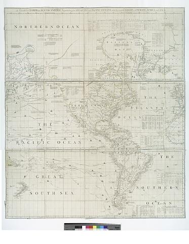
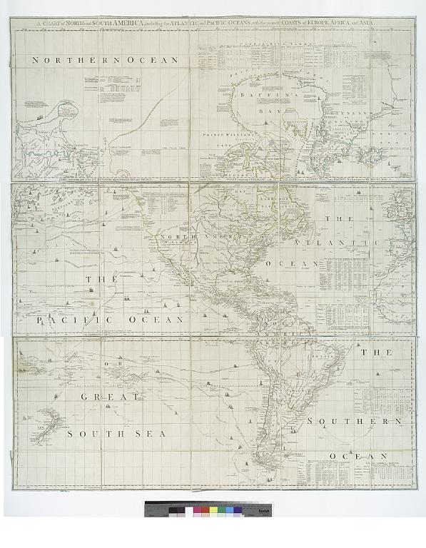
File:A chart of North and South America - including the Atlantic and Pacific Oceans, with the nearest coasts of Europe, Africa and Asia. NYPL1258749.tiff

Size of this JPG preview of this TIF file: 466 × 599 pixels. Other resolutions: 186 × 240 pixels | 373 × 480 pixels | 597 × 768 pixels | 796 × 1,024 pixels | 1,592 × 2,048 pixels | 6,241 × 8,028 pixels.
Original file (6,241 × 8,028 pixels, file size: 143.35 MB, MIME type: image/tiff)
Captions
Captions
Add a one-line explanation of what this file represents
Summary
edit| Description | A chart of North and South America : including the Atlantic and Pacific Oceans, with the nearest coasts of Europe, Africa and Asia.; Lawrence H. Slaughter Collection of English maps, charts, globes, books and atlases / Charts and maps | |||||||||||||||||||||||
| Notes | Prime meridian: London and Ferro. ''Note 2.'') Relief shown pictorially. ''Note 3.'') Shows nautical exploration routes. ''Note 4.'') "According to act of Parliament." ''Note 5.'') Includes text, historical and geographical notes, and tables of comparative astronomical observations. ''Note 6.'') Chart containing part of the Icy Sea with the adjacent coast of Asia and America and Chart comprizing Greenland with the countries and islands about Baffin's and Hudson's Bays -- [Chart containing the coasts of California, New Albion, and Russian discoveries to the north and Chart of the Atlantic Ocean, with the British, French, and Spanish settlements in North America, and the West Indies -- Chart containing the greater part of the South Sea to t .... ;''Note 7.'') National Endowment for the Humanities Grant for Access to Early Maps of the Middle Atlantic Seaboard. | |||||||||||||||||||||||
| Catalogue call number | Map Div. 97-6433 [LHS 771 (central and south sheets), LHS 772 (north sheet)] | |||||||||||||||||||||||
| Standard reference | Stevens and Tree. Comparative cartography, 4d | |||||||||||||||||||||||
| Date | ||||||||||||||||||||||||
| Source |
http://digitalgallery.nypl.org/nypldigital/dgkeysearchdetail.cfm?imageID=1950058
|
|||||||||||||||||||||||
| Author | Robert Sayer and John Bennett (Firm) -- Publisher | |||||||||||||||||||||||
| Permission (Reusing this file) |
From The Lionel Pincus & Princess Firyal Map Division. http://maps.nypl.org
|
|||||||||||||||||||||||
| Other versions |
 |
|||||||||||||||||||||||
| Location | Stephen A. Schwarzman Building / The Lionel Pincus and Princess Firyal Map Division | |||||||||||||||||||||||
| Digital item published | 1-3-2005; updated 3-25-2011 | |||||||||||||||||||||||
| Digital ID | 1258749 | |||||||||||||||||||||||

The making of this file was supported by Wikimedia UK.
To see other files made with the support of Wikimedia UK, please see the category Supported by Wikimedia UK.
|
File history
Click on a date/time to view the file as it appeared at that time.
| Date/Time | Thumbnail | Dimensions | User | Comment | |
|---|---|---|---|---|---|
| current | 07:30, 20 April 2014 |  | 6,241 × 8,028 (143.35 MB) | Fæ (talk | contribs) | GWToolset:: Creating mediafile for Fæ. Tranche 2.229 |
You cannot overwrite this file.
File usage on Commons
There are no pages that use this file.