File:A collection of plans of fortifications and battles, 1684-1709 - (Europe) LOC 2008621715-29.tif

Size of this JPG preview of this TIF file: 708 × 599 pixels. Other resolutions: 284 × 240 pixels | 567 × 480 pixels | 907 × 768 pixels | 1,210 × 1,024 pixels | 2,419 × 2,048 pixels | 9,665 × 8,182 pixels.
Original file (9,665 × 8,182 pixels, file size: 226.25 MB, MIME type: image/tiff)
Captions
Captions
Add a one-line explanation of what this file represents
Summary
edit| Warning | The original file is very high-resolution. It might not load properly or could cause your browser to freeze when opened at full size. |
|---|
| Description |
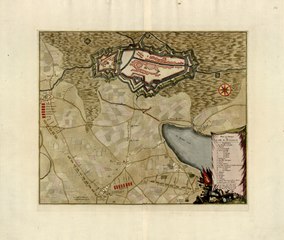
English: Relief shown by hachures and pictorially. Title from cover of composite atlas. Dates on maps range from 1684 to 1709. Beeck was the publisher of battle plans at The Hague from 1702 to 1709. Phillips, 5152 An atlas factice of 117 hand col. maps on 115 sheets. Available also through the Library of Congress Web site as a raster image. Register in French. Maps in French, Dutch, Latin, and English. Phillips register lists and describes 116 maps. Includes a typed register and a manuscript register. Copy imperfect: Lacking physical map no. 17. Bound in grey cloth covered boards with encapsulated post bindings for map sheets. |
||
| Title | A collection of plans of fortifications and battles, 1684-1709 : [Europe] | ||
| Shelf ID | G1793 .B4 1709 | ||
| Parent | https://www.loc.gov/resource/g5700m.gct00127b/ | ||
| Sheet title | Plan et attaque la ville de St. Leeuw | ||
| Date | |||
| Source | https://www.loc.gov/item/2008621715/ | ||
| Author | Beeck, Anna; Baillieu, Gaspar De. | ||
| Permission (Reusing this file) |
|
||
| Other versions |
|
||
| Location | Europe · Europe. | ||
| Part of | American Memory · General Maps · Catalog · Geography And Map Division | ||
| Subject | Europe · Atlases · Composite Atlases · Historical Geography · Fortification · Cities And Towns · Ramillies, Battle Of, Belgium · Maps · Early Works To 1800 · Spanish Succession, War Of |

_LOC_2008621715-29.jpg)
Licensing
edit|
This is a faithful photographic reproduction of a two-dimensional, public domain work of art. The work of art itself is in the public domain for the following reason:
The official position taken by the Wikimedia Foundation is that "faithful reproductions of two-dimensional public domain works of art are public domain".
This photographic reproduction is therefore also considered to be in the public domain in the United States. In other jurisdictions, re-use of this content may be restricted; see Reuse of PD-Art photographs for details. | ||||
| Annotations | This image is annotated: View the annotations at Commons |
File history
Click on a date/time to view the file as it appeared at that time.
| Date/Time | Thumbnail | Dimensions | User | Comment | |
|---|---|---|---|---|---|
| current | 01:11, 13 July 2018 |  | 9,665 × 8,182 (226.25 MB) | Fæ (talk | contribs) | LOC Maps multisheet https://www.loc.gov/item/2008621715/ sheet 29 of 42 #637 |
You cannot overwrite this file.
File usage on Commons
The following page uses this file: