File:A map, of the principal canal and rail road improvments (sic), which will connect with the Balt. & Susqa. Rail Road at York; drawn by G. F. de la Roche. C. Engr. LOC 98688595.jpg

Size of this preview: 580 × 599 pixels. Other resolutions: 232 × 240 pixels | 465 × 480 pixels | 744 × 768 pixels | 991 × 1,024 pixels | 1,983 × 2,048 pixels | 4,839 × 4,998 pixels.
Original file (4,839 × 4,998 pixels, file size: 3.47 MB, MIME type: image/jpeg)
Captions
Captions
Add a one-line explanation of what this file represents
Summary edit
| Description |
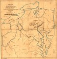
English: Outline map covering New York, Pennsylvania, New Jersey, Delaware, Maryland, Virginia, and Ohio; shows drainage, canals, important cities, and railroad connections, chartered in 1828, opened to York in 1838. |
||
| Title | A map, of the principal canal and rail road improvments [sic], which will connect with the Balt. & Susqa. Rail Road at York; drawn by G. F. de la Roche. C. Engr. | ||
| Shelf ID | G3711.P3 1835 .D3 | ||
| Date | |||
| Source | https://www.loc.gov/item/98688595/ | ||
| Author | De La Roche, G. F.; Baltimore And Susquehanna Railroad Company | ||
| Permission (Reusing this file) |
|
||
| Other versions |
|
||
| Location | Northeastern States · United States | ||
| Part of | American Memory · Catalog · Railroad Maps, 1828-1900 · Geography And Map Division · Transportation And Communication | ||
| Subject | Northeastern States · Maps · Railroads · Baltimore And Susquehanna Railroad Company · United States |

,_which_will_connect_with_the_Balt._%26_Susqa._Rail_Road_at_York;_drawn_by_G._F._de_la_Roche._C._Engr._LOC_98688595.jpg&action=edit§ion=1)
Licensing edit
,_which_will_connect_with_the_Balt._%26_Susqa._Rail_Road_at_York;_drawn_by_G._F._de_la_Roche._C._Engr._LOC_98688595.jpg&action=edit§ion=2)
|
This is a faithful photographic reproduction of a two-dimensional, public domain work of art. The work of art itself is in the public domain for the following reason:
The official position taken by the Wikimedia Foundation is that "faithful reproductions of two-dimensional public domain works of art are public domain".
This photographic reproduction is therefore also considered to be in the public domain in the United States. In other jurisdictions, re-use of this content may be restricted; see Reuse of PD-Art photographs for details. | ||||
File history
Click on a date/time to view the file as it appeared at that time.
| Date/Time | Thumbnail | Dimensions | User | Comment | |
|---|---|---|---|---|---|
| current | 10:58, 22 September 2018 | | 4,839 × 4,998 (3.47 MB) | Fæ (talk | contribs) | LOC Maps https://www.loc.gov/item/98688595/ #2491 |
You cannot overwrite this file.
File usage on Commons
The following page uses this file:
,_which_will_connect_with_the_Balt._%26_Susqa._Rail_Road_at_York;_drawn_by_G._F._de_la_Roche._C._Engr._LOC_98688595.jpg&oldid=778486398)