File:A map of America or the New World - wherein are introduced all the known parts of the Western Hemisphere, from the map of D'Anville, with the necessary alterations, and the addition of the discoveries NYPL434527.tiff

Size of this JPG preview of this TIF file: 722 × 599 pixels. Other resolutions: 289 × 240 pixels | 578 × 480 pixels | 925 × 768 pixels | 1,234 × 1,024 pixels | 2,467 × 2,048 pixels | 5,731 × 4,757 pixels.
Original file (5,731 × 4,757 pixels, file size: 78 MB, MIME type: image/tiff)
Captions
Captions
Add a one-line explanation of what this file represents
Summary edit
| Description | 1797 map. A map of America or the New World : wherein are introduced all the known parts of the Western Hemisphere, from the map of D'Anville, with the necessary alterations, and the addition of the discoveries made since the year 1761 / Wm. Palmer sculp.; Lawrence H. Slaughter Collection of English maps, charts, globes, books and atlases / Charts and maps | |||||||||||||||||||||||
| Notes | Includes notes. ''Note 2.'') National Endowment for the Humanities Grant for Access to Early Maps of the Middle Atlantic Seaboard. ''Note 3.'') Relief shown pictorially. ''Note 4.'') Lawrence H. Slaughter Collection ; 752. | |||||||||||||||||||||||
| Catalogue call number | Map Div. 97-6415 [LHS 752] | |||||||||||||||||||||||
| Standard reference | Wagner, H.R. Cartography of the northwest coast of America to the year 1800, II, 836 | |||||||||||||||||||||||
| Date | ||||||||||||||||||||||||
| Source |
http://digitalgallery.nypl.org/nypldigital/dgkeysearchdetail.cfm?imageID=434527
|
|||||||||||||||||||||||
| Author | Faden, William, 1750?-1836 -- Publisher; Palmer, W. (William), 1739-1812 -- Engraver | |||||||||||||||||||||||
| Permission (Reusing this file) |
From The Lionel Pincus and Princess Firyal Map Division. http://maps.nypl.org
|
|||||||||||||||||||||||
| Location | Stephen A. Schwarzman Building / The Lionel Pincus and Princess Firyal Map Division | |||||||||||||||||||||||
| Digital item published | 2-3-2004; updated 3-25-2011 | |||||||||||||||||||||||
| Digital ID | 434527 | |||||||||||||||||||||||

The making of this file was supported by Wikimedia UK.
To see other files made with the support of Wikimedia UK, please see the category Supported by Wikimedia UK.
|
File history
Click on a date/time to view the file as it appeared at that time.
| Date/Time | Thumbnail | Dimensions | User | Comment | |
|---|---|---|---|---|---|
| current | 07:03, 25 July 2022 |  | 5,731 × 4,757 (78 MB) | Sebastian Wallroth (talk | contribs) | Rotated 270° using CropTool with lossless mode. |
| 10:22, 20 April 2014 | 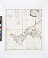 | 4,760 × 5,731 (78.05 MB) | Fæ (talk | contribs) | GWToolset:: Creating mediafile for Fæ. Tranche 2.590 |
You cannot overwrite this file.
File usage on Commons
There are no pages that use this file.