File:A map of Maryland with the Delaware counties and the southern part of New Jersey etc - by T. Kitchin, geogr. NYPL434625.tiff

Size of this JPG preview of this TIF file: 800 × 561 pixels. Other resolutions: 320 × 224 pixels | 640 × 449 pixels | 1,024 × 718 pixels | 1,280 × 897 pixels | 2,560 × 1,794 pixels | 3,343 × 2,343 pixels.
Original file (3,343 × 2,343 pixels, file size: 22.44 MB, MIME type: image/tiff)
Captions
Captions
Add a one-line explanation of what this file represents
Summary edit
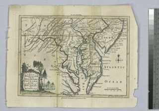
| Description | A map of Maryland with the Delaware counties and the southern part of New Jersey etc / by T. Kitchin, geogr.; Lawrence H. Slaughter Collection of English maps, charts, globes, books and atlases / Charts and maps | |||||||||||||||||||||||
| Notes | "For the Lond[on] Mag[azine]" [August 1757, v. 26]. ''Note 2.'') Copy in Map Div. 00-443: Emmet Collection. ''Note 3.'') Map Div 00-443 has been trimmed and matted with paper; lacks original margin. ''Note 4.'') National Endowment for the Humanities Grant for Access to Early Maps of the Middle Atlantic Seaboard. ''Note 5.'') Prime meridians: Philadelphia and London. ''Note 6.'') Relief shown pictorially. ''Note 7.'') Lawrence H. Slaughter Collection ; 152. | |||||||||||||||||||||||
| Catalogue call number | Map Div. 00-443 [Emmet] | |||||||||||||||||||||||
| Standard reference | LC Maps of North America, 1750-1789, 1411 | |||||||||||||||||||||||
| Date | ||||||||||||||||||||||||
| Source |
http://digitalgallery.nypl.org/nypldigital/dgkeysearchdetail.cfm?imageID=434625
|
|||||||||||||||||||||||
| Author | Baldwin, R. (Robert), 1737-1810 -- Bookseller; Kitchin, Thomas, d. 1784 -- Engraver | |||||||||||||||||||||||
| Permission (Reusing this file) |
From The Lionel Pincus and Princess Firyal Map Division. http://maps.nypl.org
|
|||||||||||||||||||||||
| Location | Stephen A. Schwarzman Building / The Lionel Pincus and Princess Firyal Map Division | |||||||||||||||||||||||
| Digital item published | 10-1-2004; updated 3-25-2011 | |||||||||||||||||||||||
| Digital ID | 434625 | |||||||||||||||||||||||

The making of this file was supported by Wikimedia UK.
To see other files made with the support of Wikimedia UK, please see the category Supported by Wikimedia UK.
|
File history
Click on a date/time to view the file as it appeared at that time.
| Date/Time | Thumbnail | Dimensions | User | Comment | |
|---|---|---|---|---|---|
| current | 10:21, 20 April 2014 |  | 3,343 × 2,343 (22.44 MB) | Fæ (talk | contribs) | GWToolset:: Creating mediafile for Fæ. Tranche 2.590 |
You cannot overwrite this file.
File usage on Commons
There are no pages that use this file.