File:A map of North America with the European settlements and whatever else is remarkable in ye West Indies from the latest and best observations - R.W. Seale delin. et sculp. NYPL434915.tiff

Size of this JPG preview of this TIF file: 683 × 599 pixels. Other resolutions: 274 × 240 pixels | 547 × 480 pixels | 875 × 768 pixels | 1,167 × 1,024 pixels | 2,334 × 2,048 pixels | 5,698 × 5,000 pixels.
Original file (5,698 × 5,000 pixels, file size: 81.52 MB, MIME type: image/tiff)
Captions
Captions
Add a one-line explanation of what this file represents
Summary edit
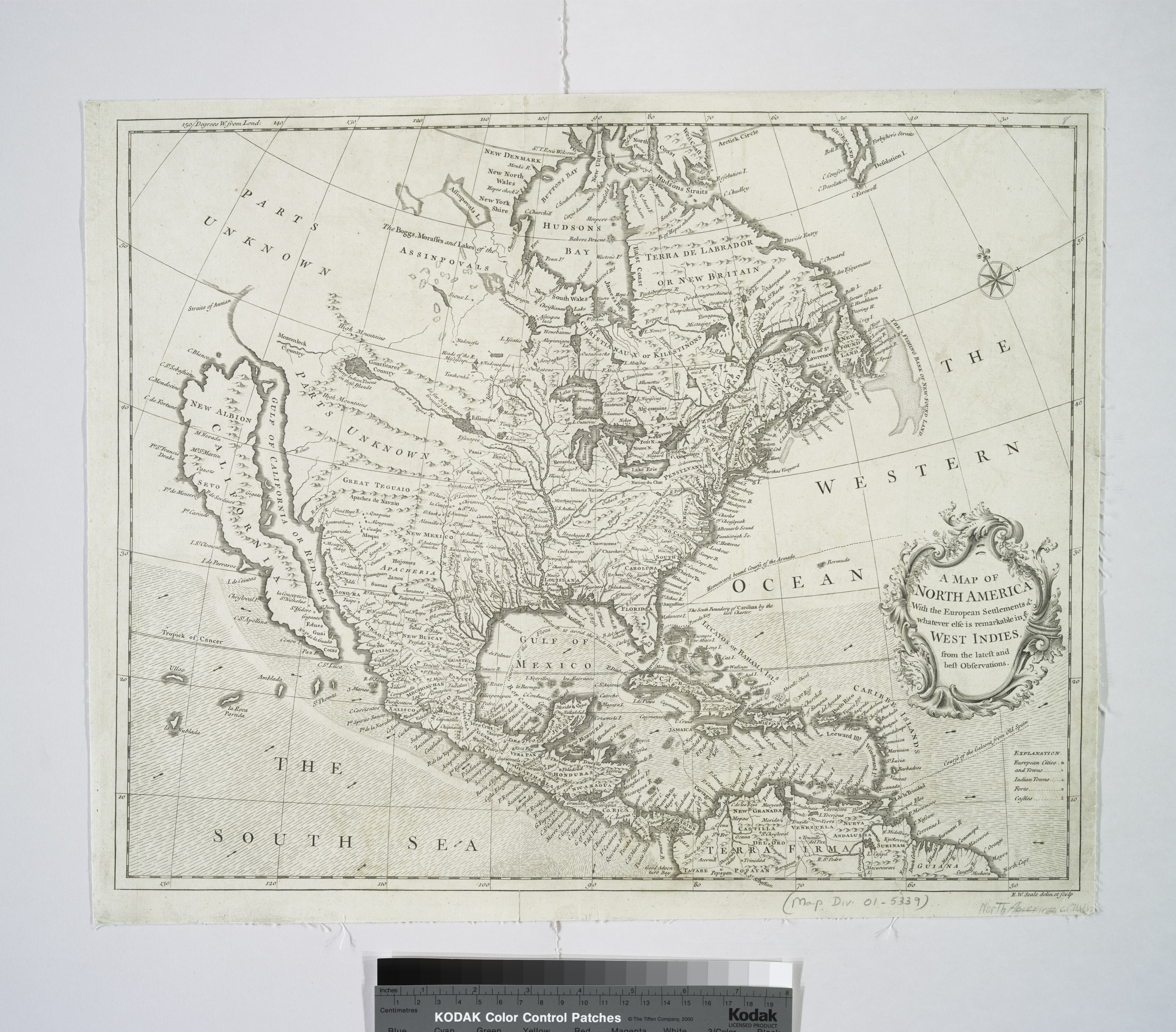
| Description | A map of North America with the European settlements and whatever else is remarkable in ye West Indies from the latest and best observations / R.W. Seale delin. et sculp.; Maps of North America. / Whole | |||||||||||||||||||||||
| Notes | Appears in: Rapin de Thoyras, Paul. The history of England, translated by N. Tindal. London, 1744. v. 3. ''Note 2.'') National Endowment for the Humanities Grant for Access to Early Maps of the Middle Atlantic Seaboard. ''Note 3.'') Prime meridian: London. ''Note 4.'') Shows California as an island. Describes western and northwestern portions of North America as "Parts Unknown." ''Note 5.'') Relief shown pictorially. | |||||||||||||||||||||||
| Catalogue call number | Map Div. 01-5339 | |||||||||||||||||||||||
| Standard reference | Phillips. Maps of America, p. 571 | |||||||||||||||||||||||
| Date | ||||||||||||||||||||||||
| Source |
http://digitalgallery.nypl.org/nypldigital/dgkeysearchdetail.cfm?imageID=434915
|
|||||||||||||||||||||||
| Author | John and Paul Knapton (Firm) -- Publisher ;Tindal, N. (Nicolas), 1687-1774 -- Translator; Seale, Richard William -- Engraver | |||||||||||||||||||||||
| Permission (Reusing this file) |
From The Lionel Pincus and Princess Firyal Map Division. http://maps.nypl.org
|
|||||||||||||||||||||||
| Location | Stephen A. Schwarzman Building / The Lionel Pincus and Princess Firyal Map Division | |||||||||||||||||||||||
| Digital item published | 10-1-2004; updated 3-25-2011 | |||||||||||||||||||||||
| Digital ID | 434915 | |||||||||||||||||||||||

The making of this file was supported by Wikimedia UK.
To see other files made with the support of Wikimedia UK, please see the category Supported by Wikimedia UK.
|
File history
Click on a date/time to view the file as it appeared at that time.
| Date/Time | Thumbnail | Dimensions | User | Comment | |
|---|---|---|---|---|---|
| current | 09:30, 19 January 2023 |  | 5,698 × 5,000 (81.52 MB) | Sebastian Wallroth (talk | contribs) | rotated 90° using CropTool with lossless mode. |
| 10:27, 20 April 2014 |  | 5,000 × 5,699 (81.53 MB) | Fæ (talk | contribs) | GWToolset:: Creating mediafile for Fæ. Tranche 2.590 |
You cannot overwrite this file.
File usage on Commons
There are no pages that use this file.