File:A map of the United States of North America LOC 2002621157.jpg

Size of this preview: 705 × 600 pixels. Other resolutions: 282 × 240 pixels | 564 × 480 pixels | 903 × 768 pixels | 1,204 × 1,024 pixels | 2,408 × 2,048 pixels | 17,743 × 15,091 pixels.
Original file (17,743 × 15,091 pixels, file size: 37.7 MB, MIME type: image/jpeg)
Captions
Captions
Add a one-line explanation of what this file represents
Summary
edit| Warning | The original file is very high-resolution. It might not load properly or could cause your browser to freeze when opened at full size. |
|---|
| Description |
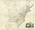
English: Relief shown by hachures. Arrowsmith moved to 10 Soho Square in 1808. In lower margins of all sheets: London. Published as the act directs by A. Arrowsmith, No. 10 Soho Square, Jan. 1st, 1796. Watermark: J Whatman 1811. This is Tooley's 1802-[1808] (e) issue of the map. R.V. Tooley, Mapping of America, 1980, 79. Available also through the Library of Congress Web site as a raster image. Includes notes, ill. of Niagara Falls, and text on Niagara Falls, as well as new place names and rivers added after the 1802 (c) issue of the map. LC copy imperfect: Brittle, creased, and with small tears and missing pieces along edges. Appears to have been bound in an atlas. Acquisitions control no. 99-32 |
||
| Title | A map of the United States of North America | ||
| Shelf ID | G3700 1808 .A6 G3700 1808 .A6 Copy 2 G3700 1808 .A6 Copy 3 G3700 1808 .A6 Copy 4 | ||
| Date | |||
| Source | https://www.loc.gov/item/2002621157/ | ||
| Author | Arrowsmith, Aaron | ||
| Permission (Reusing this file) |
|
||
| Other versions |
|
||
| Location | United States | ||
| Part of | American Memory · General Maps · Catalog · Geography And Map Division | ||
| Subject | United States · Maps |

Licensing
edit
|
This is a faithful photographic reproduction of a two-dimensional, public domain work of art. The work of art itself is in the public domain for the following reason:
The official position taken by the Wikimedia Foundation is that "faithful reproductions of two-dimensional public domain works of art are public domain".
This photographic reproduction is therefore also considered to be in the public domain in the United States. In other jurisdictions, re-use of this content may be restricted; see Reuse of PD-Art photographs for details. | ||||
File history
Click on a date/time to view the file as it appeared at that time.
| Date/Time | Thumbnail | Dimensions | User | Comment | |
|---|---|---|---|---|---|
| current | 11:28, 12 June 2018 | | 17,743 × 15,091 (37.7 MB) | Fæ (talk | contribs) | LOC Maps https://www.loc.gov/item/2002621157/ #27926 |
You cannot overwrite this file.
File usage on Commons
The following page uses this file: