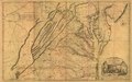
File:A map of the most inhabited part of Virginia containing the whole province of Maryland with part of Pensilvania, New Jersey and North Carolina. LOC 74693166.jpg

Size of this preview: 800 × 502 pixels. Other resolutions: 320 × 201 pixels | 640 × 402 pixels | 1,024 × 643 pixels | 1,280 × 804 pixels | 2,560 × 1,607 pixels | 15,216 × 9,552 pixels.
Original file (15,216 × 9,552 pixels, file size: 24.43 MB, MIME type: image/jpeg)
Captions
Captions
Add a one-line explanation of what this file represents
Summary edit
| Warning | The original file is very high-resolution. It might not load properly or could cause your browser to freeze when opened at full size. |
|---|
| Description |
English: Scale ca. 1:650,000. Hand colored. Prime meridian: Philadelphia and Curratuck Inlet. Relief shown pictorially. "To the Right Honourable, George Dunk Earl of Halifax ..." LC Maps of North America, 1750-1789, 1428 Includes distance chart added by "J. Dalrymple, London Jany. ye. 1st. 1755." Available also through the Library of Congress Web site as a raster image. Vault AACR2 |
||
| Title | A map of the most inhabited part of Virginia containing the whole province of Maryland with part of Pensilvania, New Jersey and North Carolina. | ||
| Shelf ID | G3880 1755 .F72 | ||
| Date | |||
| Source | https://www.loc.gov/item/74693166/ | ||
| Author | Fry, Joshua; Jefferson, Peter; Jefferys, Thomas | ||
| Permission (Reusing this file) |
|
||
| Other versions |
|
||
| Location | United States · Maryland · Middle Atlantic States · Virginia | ||
| Part of | Military Battles And Campaigns · General Maps · Catalog · American Memory · Geography And Map Division · American Revolution And Its Era: Maps And Charts Of North America And The West Indies, 1750-1789 | ||
| Subject | Virginia · United States · Maps · Early Works To 1800 · Middle Atlantic States · Maryland |

Licensing edit
|
This is a faithful photographic reproduction of a two-dimensional, public domain work of art. The work of art itself is in the public domain for the following reason:
The official position taken by the Wikimedia Foundation is that "faithful reproductions of two-dimensional public domain works of art are public domain".
This photographic reproduction is therefore also considered to be in the public domain in the United States. In other jurisdictions, re-use of this content may be restricted; see Reuse of PD-Art photographs for details. | ||||
File history
Click on a date/time to view the file as it appeared at that time.
| Date/Time | Thumbnail | Dimensions | User | Comment | |
|---|---|---|---|---|---|
| current | 15:00, 3 June 2018 | | 15,216 × 9,552 (24.43 MB) | Fæ (talk | contribs) | LOC Maps https://www.loc.gov/item/74693166/ #3491 |
You cannot overwrite this file.
File usage on Commons
The following page uses this file: