File:A new and accurate map of North Carolina in North America. LOC 2013593295.jpg

Size of this preview: 731 × 600 pixels. Other resolutions: 293 × 240 pixels | 585 × 480 pixels | 936 × 768 pixels | 1,249 × 1,024 pixels | 2,497 × 2,048 pixels | 4,328 × 3,550 pixels.
Original file (4,328 × 3,550 pixels, file size: 2.68 MB, MIME type: image/jpeg)
Captions
Captions
Add a one-line explanation of what this file represents
Summary
edit| Description |
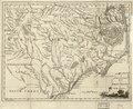
English: Shows counties, towns, courthouses, "Dobbs Parish," churches, forts, rivers, swamps, shoals, and inlets along the coast. Covers the area from Cape Hatteras to Rowen County. Relief shown by contours. Mounted on cloth. From The Universal Magazine of knowledge and Pleasure (October, 1779), vol. 65. LC Maps of North America, 1750-1789, 1501 Available also through the Library of Congress Web site as a raster image. |
||
| Title | A new and accurate map of North Carolina in North America. | ||
| Shelf ID | G3900 1779 .N4 | ||
| Date | |||
| Source | https://www.loc.gov/item/2013593295/ | ||
| Author | Unknown author | ||
| Permission (Reusing this file) |
|
||
| Other versions |
|
||
| Location | United States · North Carolina | ||
| Part of | Military Battles And Campaigns · American Memory · Catalog · Geography And Map Division · American Revolution And Its Era: Maps And Charts Of North America And The West Indies, 1750-1789 | ||
| Subject | United States · Maps · Early Works To 1800 · Early Maps · North Carolina |

Licensing
edit
|
This is a faithful photographic reproduction of a two-dimensional, public domain work of art. The work of art itself is in the public domain for the following reason:
The official position taken by the Wikimedia Foundation is that "faithful reproductions of two-dimensional public domain works of art are public domain".
This photographic reproduction is therefore also considered to be in the public domain in the United States. In other jurisdictions, re-use of this content may be restricted; see Reuse of PD-Art photographs for details. | ||||
File history
Click on a date/time to view the file as it appeared at that time.
| Date/Time | Thumbnail | Dimensions | User | Comment | |
|---|---|---|---|---|---|
| current | 04:45, 24 July 2018 | | 4,328 × 3,550 (2.68 MB) | Fæ (talk | contribs) | LOC Maps https://www.loc.gov/item/2013593295/ #10566 |
You cannot overwrite this file.
File usage on Commons
The following page uses this file: