File:A new map of Arkansas with its canals, roads & distances. LOC gm72003746.jpg

Size of this preview: 484 × 599 pixels. Other resolutions: 194 × 240 pixels | 388 × 480 pixels | 620 × 768 pixels | 827 × 1,024 pixels | 1,654 × 2,048 pixels | 7,463 × 9,239 pixels.
Original file (7,463 × 9,239 pixels, file size: 9.37 MB, MIME type: image/jpeg)
Captions
Captions
Add a one-line explanation of what this file represents
Summary edit
| Description |
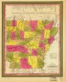
English: Scale ca. 1:1,700,000. Hand colored. Relief shown by hachures. "25" in upper right corner. Available also through the Library of Congress Web site as a raster image. Includes "Steam boat routes." AACR2 |
||
| Title | A new map of Arkansas with its canals, roads & distances. | ||
| Shelf ID | G4000 1847 .M5 | ||
| Date | |||
| Source | https://www.loc.gov/item/gm72003746/ | ||
| Author | Mitchell, S. Augustus (Samuel Augustus); Mitchell, S. Augustus | ||
| Permission (Reusing this file) |
|
||
| Other versions |
|
||
| Location | United States · Arkansas | ||
| Part of | American Memory · General Maps · Catalog · Geography And Map Division | ||
| Subject | Distances, Etc · Maps · Arkansas · United States |

Licensing edit
|
This is a faithful photographic reproduction of a two-dimensional, public domain work of art. The work of art itself is in the public domain for the following reason:
The official position taken by the Wikimedia Foundation is that "faithful reproductions of two-dimensional public domain works of art are public domain".
This photographic reproduction is therefore also considered to be in the public domain in the United States. In other jurisdictions, re-use of this content may be restricted; see Reuse of PD-Art photographs for details. | ||||
File history
Click on a date/time to view the file as it appeared at that time.
| Date/Time | Thumbnail | Dimensions | User | Comment | |
|---|---|---|---|---|---|
| current | 10:08, 4 June 2018 | | 7,463 × 9,239 (9.37 MB) | Fæ (talk | contribs) | LOC Maps https://www.loc.gov/item/gm72003746/ #4460 |
You cannot overwrite this file.
File usage on Commons
The following page uses this file: