File:A new map of the island of Jamaica divided into its parishes - including the south end of Cuba and the west end of Hispaniola with the trade winds etc. LOC 2010593350.tif

Size of this JPG preview of this TIF file: 786 × 599 pixels. Other resolutions: 315 × 240 pixels | 630 × 480 pixels | 1,007 × 768 pixels | 1,280 × 976 pixels | 2,560 × 1,952 pixels | 7,316 × 5,579 pixels.
Original file (7,316 × 5,579 pixels, file size: 116.78 MB, MIME type: image/tiff)
Captions
Captions
Add a one-line explanation of what this file represents
Summary
edit| Description |
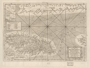
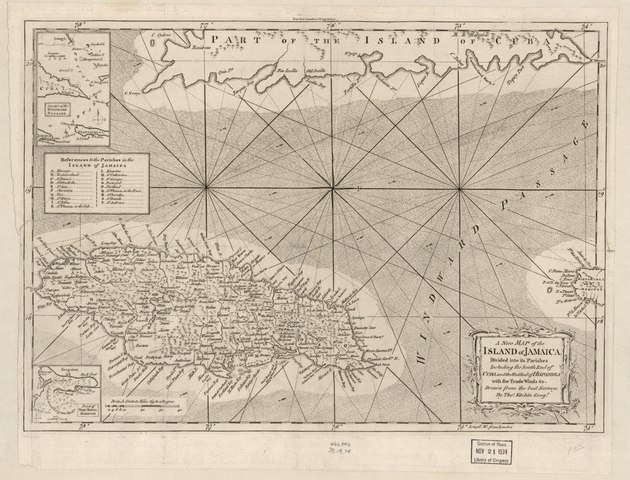
English: Relief shown pictorially. LC Maps of North America, 1750-1789, 1921 Available also through the Library of Congress Web site as a raster image. From London magazine, or, Gentleman's monthly intelligencer. July 1763, v. 32. Indexed. Insets: Chart of the Windward Passage -- Plan of Port Royal Harbour. |
||
| Title | A new map of the island of Jamaica divided into its parishes : including the south end of Cuba and the west end of Hispaniola with the trade winds &c. | ||
| Shelf ID | G4960 1765 .K5 | ||
| Date | |||
| Source | https://www.loc.gov/item/2010593350/ | ||
| Author | Kitchin, Thomas | ||
| Permission (Reusing this file) |
|
||
| Other versions |
|
||
| Location | Jamaica · Jamaica. | ||
| Part of | Military Battles And Campaigns · American Memory · Catalog · Geography And Map Division · American Revolution And Its Era: Maps And Charts Of North America And The West Indies, 1750-1789 | ||
| Subject | Jamaica · Early Works To 1800 · Maps |


Licensing
edit|
This is a faithful photographic reproduction of a two-dimensional, public domain work of art. The work of art itself is in the public domain for the following reason:
The official position taken by the Wikimedia Foundation is that "faithful reproductions of two-dimensional public domain works of art are public domain".
This photographic reproduction is therefore also considered to be in the public domain in the United States. In other jurisdictions, re-use of this content may be restricted; see Reuse of PD-Art photographs for details. | ||||
File history
Click on a date/time to view the file as it appeared at that time.
| Date/Time | Thumbnail | Dimensions | User | Comment | |
|---|---|---|---|---|---|
| current | 10:59, 31 May 2018 |  | 7,316 × 5,579 (116.78 MB) | Fæ (talk | contribs) | LOC Maps https://www.loc.gov/item/2010593350/ #761 |
You cannot overwrite this file.
File usage on Commons
The following page uses this file: