File:A plan of New York Island, with part of Long Island, Staten Island & east New Jersey - with a particular description of the engagement on the woody heights of Long Island, between Flatbush and NYPL434000.png
Size of this preview: 455 × 600 pixels. Other resolutions: 182 × 240 pixels | 364 × 480 pixels | 582 × 768 pixels | 777 × 1,024 pixels | 1,553 × 2,048 pixels | 3,666 × 4,833 pixels.
Original file (3,666 × 4,833 pixels, file size: 29.9 MB, MIME type: image/png)
Captions
Captions
Add a one-line explanation of what this file represents
Summary edit
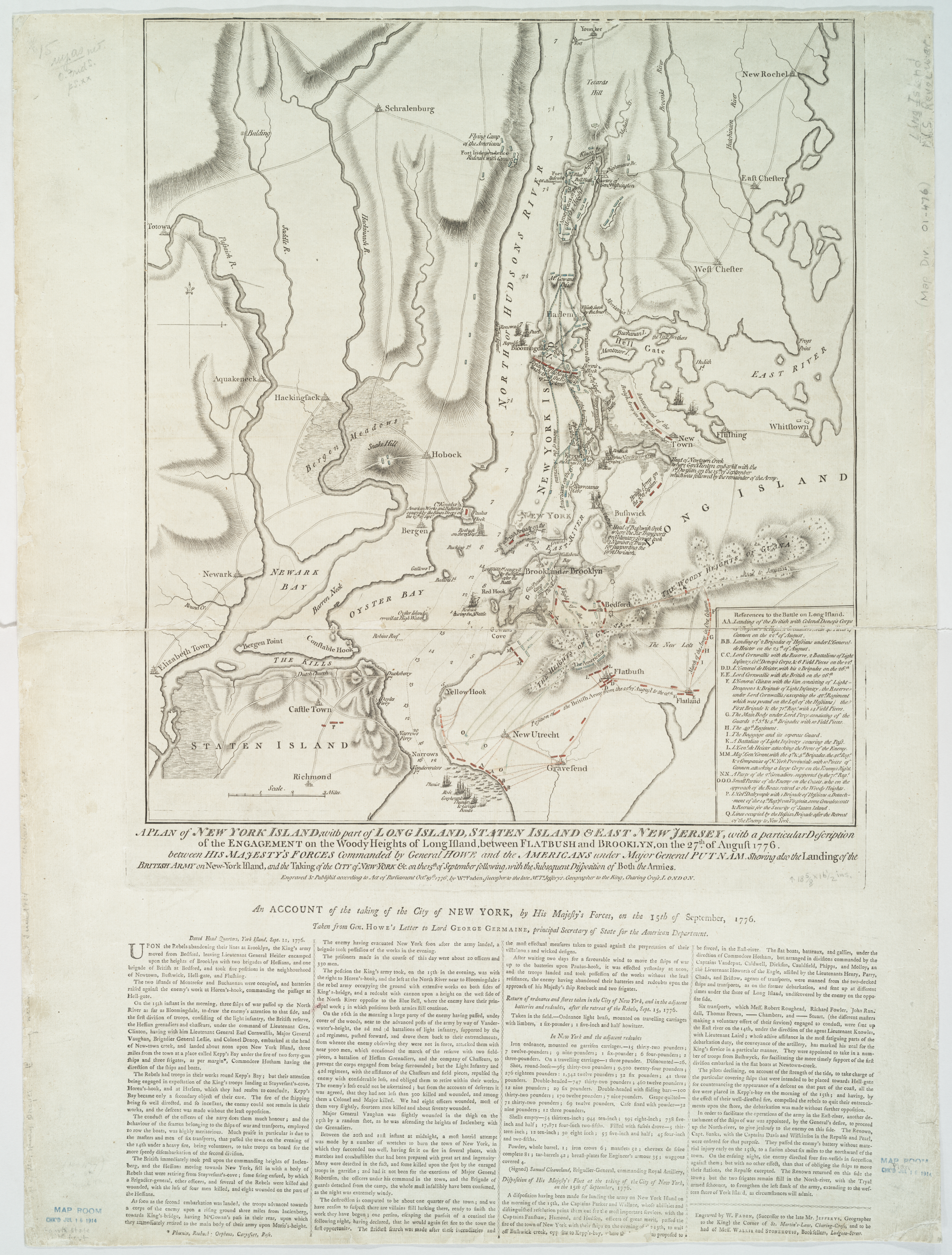
| Description | A plan of New York Island, with part of Long Island, Staten Island & east New Jersey : with a particular description of the engagement on the woody heights of Long Island, between Flatbush and Brooklyn, on the 27th of August 1776 between His Majesty's forces commanded by General Howe and the Americans under Major General Putnam, shewing also the landing of the British Army on New-York Island, and the taking of the city of New-York &c.; on the 15th of September following, with the subsequent disposition of both the armies / engraved & publish'd by ... Wm. Faden. | |||||||||||||||||||||||
| Notes | Technical note - this image is currently displaying on Wikimedia Commons with a magenta cast, this does not appear on the downloaded version. Includes "References to the battle on Long Island." and text in lower margin, "An account of the taking of the city of New York, by His Majesty's forces, on the 15th September, 1776." Note 2.) National Endowment for the Humanities Grant for Access to Early Maps of the Middle Atlantic Seaboard. Note 3.) NYPL copy annnotated in lower left corner in pencil: fourth state. Note 4.) Shows information to Sept. 26th 1776. Note 5.) Relief shown by hachures. Depths shown by soundings. | |||||||||||||||||||||||
| Standard reference | LC Maps of North America, 1750-1789, 1144; Stevens & Tree. Comparative cartography, 41d | |||||||||||||||||||||||
| Physical description | 1 map ; 48 x 43 cm. | |||||||||||||||||||||||
| Catalog Call Number | Map Div. 01-476 [Filed with N.Y.S. Revol. Maps, Long Island] | |||||||||||||||||||||||
| Date | Octr. 19th, 1776 | |||||||||||||||||||||||
| Source |
http://digitalgallery.nypl.org/nypldigital/dgkeysearchdetail.cfm?imageID=434000
|
|||||||||||||||||||||||
| Author | Faden, William, 1750?-1836 -- Engraver | |||||||||||||||||||||||
| Permission (Reusing this file) |
From The Lionel Pincus & Princess Firyal Map Division. Released on a CC0 license.[1] | |||||||||||||||||||||||
| Other versions |
 |
|||||||||||||||||||||||
| Digital ID | 434000 | |||||||||||||||||||||||
| Location | Stephen A. Schwarzman Building / The Lionel Pincus and Princess Firyal Map Division | |||||||||||||||||||||||
| NYPL digital item published | 2-3-2004; updated 3-25-2011 | |||||||||||||||||||||||

Licensing edit
| This file is made available under the Creative Commons CC0 1.0 Universal Public Domain Dedication. | |
| The person who associated a work with this deed has dedicated the work to the public domain by waiving all of their rights to the work worldwide under copyright law, including all related and neighboring rights, to the extent allowed by law. You can copy, modify, distribute and perform the work, even for commercial purposes, all without asking permission.
|
The making of this file was supported by Wikimedia UK.
To see other files made with the support of Wikimedia UK, please see the category Supported by Wikimedia UK.
|
File history
Click on a date/time to view the file as it appeared at that time.
| Date/Time | Thumbnail | Dimensions | User | Comment | |
|---|---|---|---|---|---|
| current | 00:41, 11 April 2014 | | 3,666 × 4,833 (29.9 MB) | Trlkly (talk | contribs) | Removed a buggy color profile to fix magenta tint. Also resulted in better contrast than converting. (uploaded using chunked upload script) |
| 00:32, 11 April 2014 |  | 3,666 × 4,833 (29.9 MB) | Trlkly (talk | contribs) | Removing color profile not only got rid of the purple tint, but also improved contrast. | |
| 00:21, 11 April 2014 |  | 3,666 × 4,833 (29.9 MB) | Trlkly (talk | contribs) | Removing color profile not only got rid of the purple tint, but also improved contrast. | |
| 15:54, 9 April 2014 |  | 3,666 × 4,833 (33.08 MB) | Fæ (talk | contribs) | Create png version (uploaded using chunked upload script) |
You cannot overwrite this file.
File usage on Commons
The following page uses this file: