File:Acidic substrata potential map - (Burlington County, New Jersey) LOC 89694173.jpg

Size of this preview: 492 × 600 pixels. Other resolutions: 197 × 240 pixels | 394 × 480 pixels | 630 × 768 pixels | 840 × 1,024 pixels | 1,679 × 2,048 pixels | 7,376 × 8,994 pixels.
Original file (7,376 × 8,994 pixels, file size: 10.27 MB, MIME type: image/jpeg)
Captions
Captions
Add a one-line explanation of what this file represents
Summary edit
| Description |
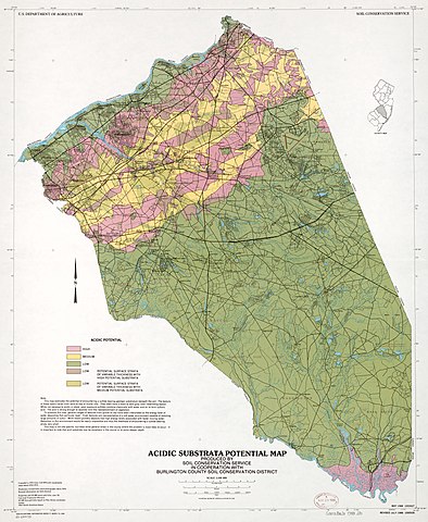
English: "This map estimates the potential of encountering a sulfide bearing geologic substratum beneath the soil." "May 1988 1003427." UTM and New Jersey coordinate grids. Includes text, notes, and location map. "1000535." Available also through the Library of Congress Web site as a raster image. |
||
| Title | Acidic substrata potential map : [Burlington County, New Jersey] | ||
| Shelf ID | G3813.B8J3 1988 .U5 | ||
| Date | |||
| Source | https://www.loc.gov/item/89694173/ | ||
| Author | United States. Soil Conservation Service; National Cartographic Center (U.S.) | ||
| Permission (Reusing this file) |
|
||
| Location | New Jersey · United States · Burlington County | ||
| Part of | American Memory · General Maps · Catalog · Geography And Map Division | ||
| Subject | United States · Burlington County · New Jersey · Soil Acidity · Maps · Sulfide Minerals |

_LOC_89694173.jpg&action=edit§ion=1)
Licensing edit
_LOC_89694173.jpg&action=edit§ion=2)
| This work is from the Library of Congress. According to the library, there are no known copyright restrictions on the use of this work. |  |
File history
Click on a date/time to view the file as it appeared at that time.
| Date/Time | Thumbnail | Dimensions | User | Comment | |
|---|---|---|---|---|---|
| current | 17:52, 24 June 2018 | | 7,376 × 8,994 (10.27 MB) | Fæ (talk | contribs) | LOC Maps https://www.loc.gov/item/89694173/ #26808 |
You cannot overwrite this file.
File usage on Commons
There are no pages that use this file.
_LOC_89694173.jpg&oldid=781300955)