File:Americae sive novi orbis, nova descriptio. NYPL1030030.tiff

Size of this JPG preview of this TIF file: 629 × 600 pixels. Other resolutions: 252 × 240 pixels | 504 × 480 pixels | 806 × 768 pixels | 1,074 × 1,024 pixels | 2,148 × 2,048 pixels | 5,379 × 5,128 pixels.
Original file (5,379 × 5,128 pixels, file size: 78.92 MB, MIME type: image/tiff)
Captions
Captions
Add a one-line explanation of what this file represents
Summary edit
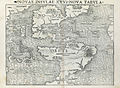
| Description | Americae sive novi orbis, nova descriptio. | |||||||||||||||||||||||
| Notes | Appears in Sebastian Münster's Cosmographey, 1614. Note 2.) On verso, with ill.: America, die newe Welt, oder Inseln so hinder Hispaniam gegen Orient bey dem Landt Indie gelegen. xxvi. | |||||||||||||||||||||||
| Standard reference | Burden, P.D. Mapping of North America, 67 | |||||||||||||||||||||||
| Physical description | 1 map ; 27 x 35 cm. | |||||||||||||||||||||||
| Catalog Call Number | Map Div. 02-333 [Filed with America,[16--], as originally cataloged in NYPL Dictionary Catalog of the Map Division] | |||||||||||||||||||||||
| Date | circa 1614 | |||||||||||||||||||||||
| Source |
http://digitalgallery.nypl.org/nypldigital/dgkeysearchdetail.cfm?imageID=1030030
|
|||||||||||||||||||||||
| Author | Henricpetri, Sebastian, 1547-1627 -- Cartographer | |||||||||||||||||||||||
| Permission (Reusing this file) |
From The Lionel Pincus & Princess Firyal Map Division. Released on a CC0 license.[1] | |||||||||||||||||||||||
| Digital ID | 1030030 | |||||||||||||||||||||||
| Location | Stephen A. Schwarzman Building / The Lionel Pincus and Princess Firyal Map Division | |||||||||||||||||||||||
| NYPL digital item published | 2-3-2004; updated 3-25-2011 | |||||||||||||||||||||||

-
 1540 tiff version
 -
 1545 book
 -
 1545 flat
 -
 1545? version
 -
 1550s version
 -
 1550s tiff version
 -
 1550s version
 -
 1556 version
 -
 1560s color
_p_123.jpg)

.jpg)


Licensing edit
| This file is made available under the Creative Commons CC0 1.0 Universal Public Domain Dedication. | |
| The person who associated a work with this deed has dedicated the work to the public domain by waiving all of their rights to the work worldwide under copyright law, including all related and neighboring rights, to the extent allowed by law. You can copy, modify, distribute and perform the work, even for commercial purposes, all without asking permission.
|
The making of this file was supported by Wikimedia UK.
To see other files made with the support of Wikimedia UK, please see the category Supported by Wikimedia UK.
|
File history
Click on a date/time to view the file as it appeared at that time.
| Date/Time | Thumbnail | Dimensions | User | Comment | |
|---|---|---|---|---|---|
| current | 08:37, 12 September 2016 |  | 5,379 × 5,128 (78.92 MB) | Finavon (talk | contribs) | rotated |
| 23:36, 4 April 2014 |  | 5,128 × 5,379 (78.92 MB) | Fæ (talk | contribs) | =={{int:filedesc}}== {{NYPL_map |digital_id = 1030030 |standard_reference = Burden, P.D. Mapping of North America, 67 |record_id = 293099 |catalog_call_number = Map Div. 02-333 [Filed with America,[16--], as originally cataloged in NYPL Dictionary Cata... |
You cannot overwrite this file.
File usage on Commons
The following 9 pages use this file:
- File:Bodleian Libraries, Sebastian Munster, La table des Isles neufues.jpg
- File:Claudius Ptolemaeus - Geographia universalis.jpg
- File:Cosmographia (Sebastian Münster) p 123.jpg
- File:Die Neuwen Inseln so hinder Hispanica gegen Orient bey dem Landt Indie ligen. NYPL434937.tiff
- File:Map of America by Sebastian Munster.JPG
- File:Novae insvlae XXVI nova tabvla. NYPL1260170.tiff
- File:Tabula nouarum insularum, quas diuersis respectibus Occidentales & Indianas uocant (NYPL b15481524-464967).jpg
- File:Tabula nouarum insularum, quas diuersis respectibus Occidentales and Indianas uocant. NYPL464967.tiff
- File:Tabula nouarum insularum, quas diuersis respectibus occidentales & indianas vocant (NYPL Hades-118524-54648).tif