File:An 1890s-vintage cemetery in Lajitas, a dusty, unincorporated town at the spot that separates Big Bend National Park and Big Bend Ranch State Park in southern Brewster County, Texas LCCN2014630629.tif
Original file (6,910 × 4,612 pixels, file size: 182.39 MB, MIME type: image/tiff)
Captions
Summary
editDescriptionAn 1890s-vintage cemetery in Lajitas, a dusty, unincorporated town at the spot that separates Big Bend National Park and Big Bend Ranch State Park in southern Brewster County, Texas LCCN2014630629.tif |
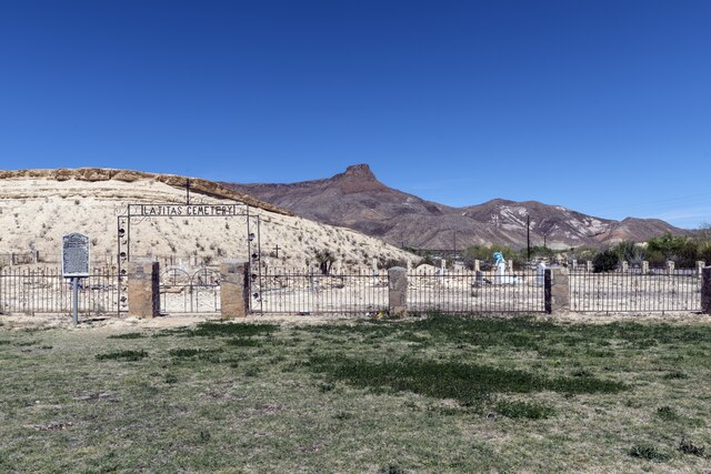
English: Title: An 1890s-vintage cemetery in Lajitas, a dusty, unincorporated town at the spot that separates Big Bend National Park and Big Bend Ranch State Park in southern Brewster County, Texas
Physical description: 1 photograph : digital, tiff file, color. Notes: Title, date, and keywords based on information provided by the photographer.; Gift; The Lyda Hill Foundation; 2014; (DLC/PP-2014:054).; Forms part of: Lyda Hill Texas Collection of Photographs in Carol M. Highsmith's America Project in the Carol M. Highsmith Archive.; Credit line: The Lyda Hill Texas Collection of Photographs in Carol M. Highsmith's America Project, Library of Congress, Prints and Photographs Division. |
||||||||||||||||||||||||||
Date | Taken on 17 March 2014, 14:16 (according to Exif data) | ||||||||||||||||||||||||||
Source |
Library of Congress
|
||||||||||||||||||||||||||
Author |
creator QS:P170,Q5044454 |
||||||||||||||||||||||||||
Permission (Reusing this file) |
No known restrictions on publication.
|
Licensing
editPublic domainPublic domainfalsefalse |
This work is from the Carol M. Highsmith Archive collection at the Library of Congress. According to the library, there are no known copyright restrictions on the use of this work. Carol M. Highsmith has stipulated that her photographs are in the public domain. Photographs of sculpture or other works of art may be restricted by the copyright of the artist; see Commons:FOP US#Artworks and sculptures for more information. |
File history
Click on a date/time to view the file as it appeared at that time.
Date/Time | Thumbnail | Dimensions | User | Comment | |
---|---|---|---|---|---|
current | 14:54, 26 September 2016 | 6,910 × 4,612 (182.39 MB) | Fæ (talk | contribs) | LOC 2014630629, Carol M. Highsmith collection. P168.21287 TIFF (182.4mb) |
You cannot overwrite this file.
File usage on Commons
There are no pages that use this file.
Metadata
This file contains additional information such as Exif metadata which may have been added by the digital camera, scanner, or software program used to create or digitize it. If the file has been modified from its original state, some details such as the timestamp may not fully reflect those of the original file. The timestamp is only as accurate as the clock in the camera, and it may be completely wrong.
Image title | An 1890s-vintage cemetery in Lajitas, a dusty, unincorporated town at the spot that separates Big Bend National Park and Big Bend Ranch State Park in southern Brewster County, Texas. According to legend, for many years the town was "governed" by Clay Henry III, a beer-drinking goat.
The name Lajitas is Spanish for "little flat rocks" and refers to the Boquillas flagstone of the area. The region was inhabited by Mexican Indians for many years. They were driven from the area by the Apaches and later by the Comanches during the eighteenth and nineteenth centuries. Anglo-Americans first arrived in the mid-1800s. In 1852 Lt. William H. Emory visited the site. In the late 1890s quicksilver was discovered near Terlingua, eleven miles from Lajitas, and a rapid influx of people followed. Farming along the narrow floodplain of the river served to bring in more families, and by 1912 the town had a store, a saloon, a school with fifty pupils, and a customhouse. The crossing, a smooth rock bottom all the way across the river, was the best between Del Rio and El Paso. According to the Texas State Historical Association, H. W. McGuirk, the leading citizen of Lajitas from 1902 to 1917, operated the store-saloon, farmed, and helped manage the Terlingua Mining Company. He also funded the construction of a church and a school. Lajitas officially had a post office as early as 1901, In 1916 the interruption of commerce by Francisco (Pancho) Villa's bandits brought Gen. John J. Pershing's troops to Lajitas, where they established a major cavalry post. In the 1980s a motel stood on the actual foundations of the post. The Lajitas property continued to change hands and in 1949 was bought by Rex Ivey, Jr., who hand-dug a well and installed a generator for the area's first electric lights. Due to the closing of the Terlingua quicksilver mines, the number of residents in Lajitas had dwindled to four. In the mid-1980s Lajitas was a resort town with fifty residents and fifteen businesses. |
---|---|
Camera manufacturer | NIKON CORPORATION |
Camera model | NIKON D800 |
Author | Photographer: Carol M. Highsmith |
Exposure time | 1/200 sec (0.005) |
F-number | f/10 |
ISO speed rating | 100 |
Date and time of data generation | 14:16, 17 March 2014 |
Lens focal length | 27 mm |
Latitude | 29° 15′ 43″ N |
Longitude | 103° 46′ 29.29″ W |
Altitude | 712 meters above sea level |
Width | 6,910 px |
Height | 4,612 px |
Bits per component |
|
Compression scheme | Uncompressed |
Pixel composition | RGB |
Image data location | 31,234 |
Orientation | Normal |
Number of components | 3 |
Number of rows per strip | 4,612 |
Bytes per compressed strip | 191,213,520 |
Horizontal resolution | 300 dpi |
Vertical resolution | 300 dpi |
Data arrangement | chunky format |
Software used | Ver.1.02 |
File change date and time | 19:37, 21 March 2014 |
Exposure Program | Manual |
Exif version | 2.21 |
Date and time of digitizing | 14:16, 17 March 2014 |
APEX shutter speed | 7.643856 |
APEX aperture | 6.643856 |
APEX exposure bias | 0 |
Maximum land aperture | 3 APEX (f/2.83) |
Metering mode | Pattern |
Light source | Unknown |
Flash | Flash did not fire, compulsory flash suppression |
DateTimeOriginal subseconds | 7 |
Color space | Uncalibrated |
Focal plane X resolution | 2,048.4022216797 |
Focal plane Y resolution | 2,048.4022216797 |
Focal plane resolution unit | 3 |
Sensing method | One-chip color area sensor |
File source | Digital still camera |
Scene type | A directly photographed image |
Custom image processing | Normal process |
Exposure mode | Manual exposure |
White balance | Auto white balance |
Digital zoom ratio | 1 |
Focal length in 35 mm film | 27 mm |
Scene capture type | Standard |
Scene control | None |
Contrast | Normal |
Saturation | Normal |
Sharpness | Normal |
Subject distance range | Unknown |
GPS time (atomic clock) | 19:16 |
Satellites used for measurement | 10 |
Reference for direction of image | Magnetic direction |
Direction of image | 327.49 |
Geodetic survey data used | WGS 84 |
GPS date | 17 March 2014 |
GPS tag version | 2.3.0.0 |