File:Angola-DRC boundary. LOC 84692090.jpg
(Redirected from File:Angola-South-West Africa boundary. LOC 84692090.jpg)
Size of this preview: 800 × 578 pixels. Other resolutions: 320 × 231 pixels | 640 × 463 pixels | 1,024 × 740 pixels | 1,280 × 925 pixels | 2,560 × 1,851 pixels | 5,721 × 4,136 pixels.
Original file (5,721 × 4,136 pixels, file size: 2.34 MB, MIME type: image/jpeg)
Captions
Captions
Add a one-line explanation of what this file represents
Summary
edit| Description |
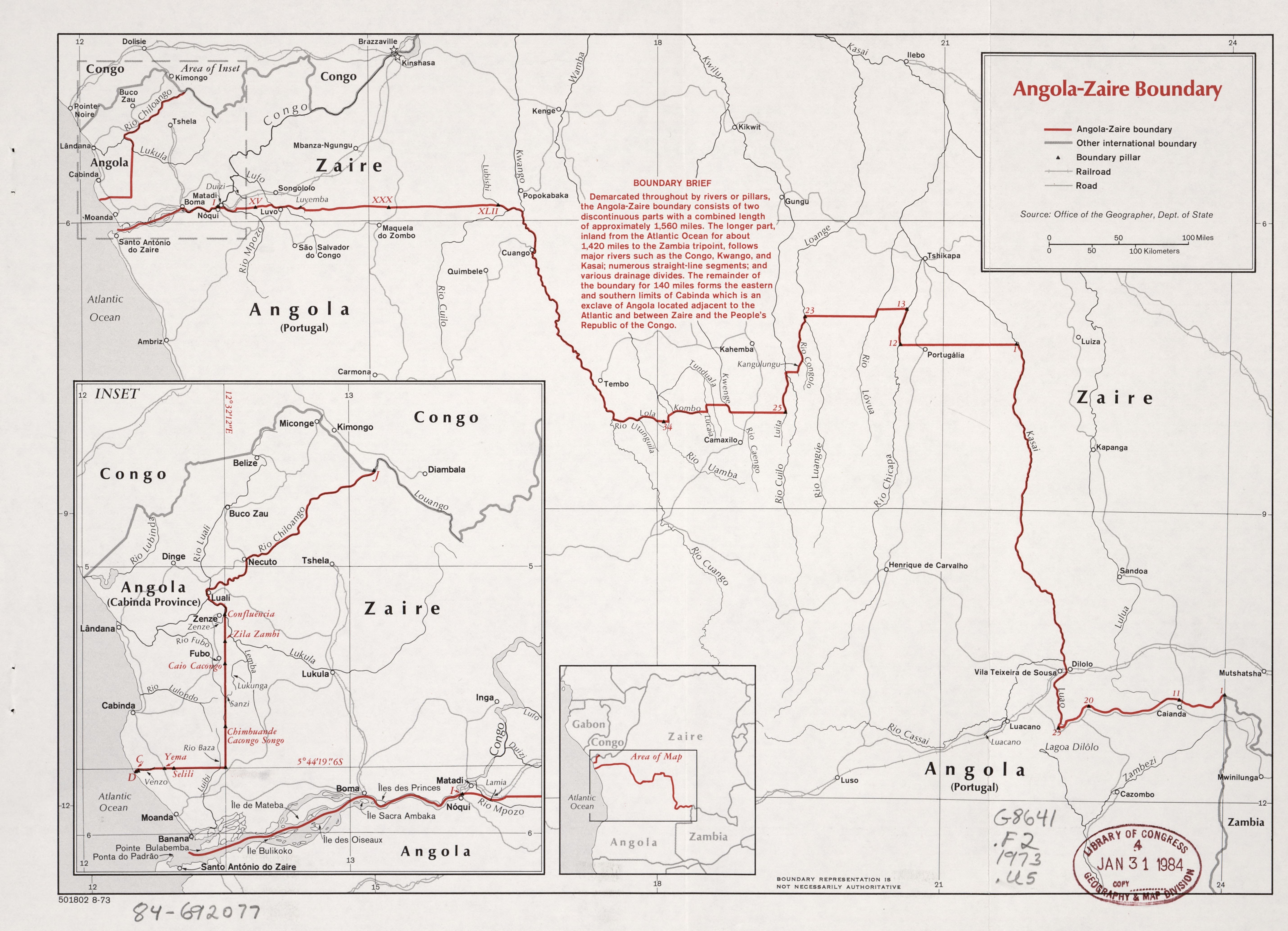
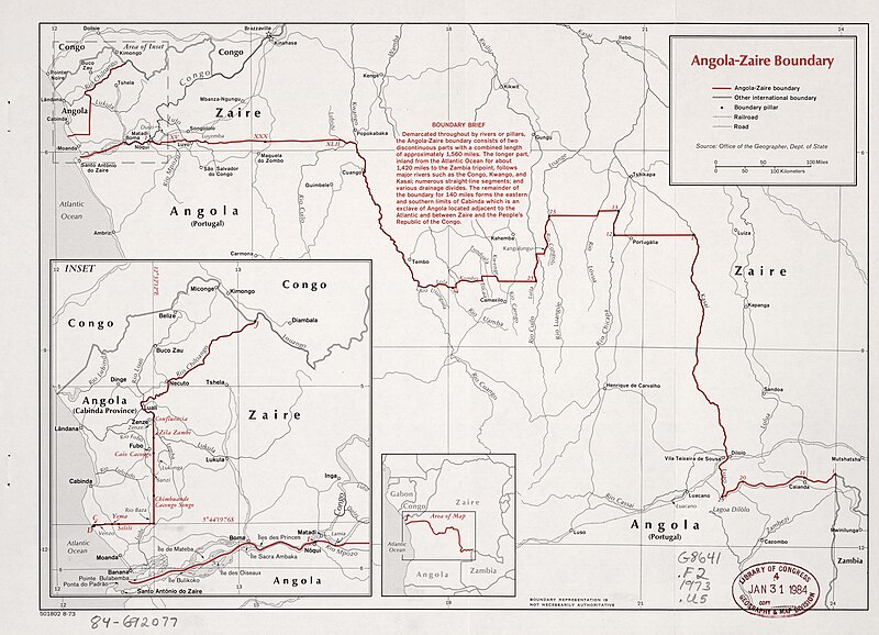
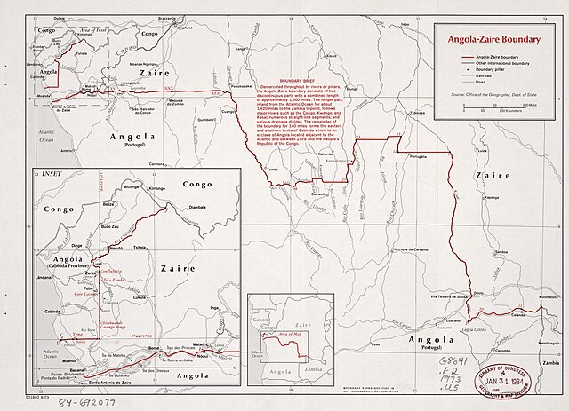
English: "501802 8-73" "Source: Office of the Geographer, Dept. of State." Includes note and key map. Available also through the Library of Congress Web site as a raster image. |
||
| Title | Angola--Zaire boundary. | ||
| Shelf ID | G8641.F2 1973 .U5 | ||
| Date | |||
| Source | https://www.loc.gov/item/84692090/ | ||
| Author | United States. Central Intelligence Agency; United States. Department Of State. Office Of The Geographer | ||
| Permission (Reusing this file) |
|
||
| Other versions |
|
||
| Location | Democratic Republic of the Congo · Angola | ||
| Part of | American Memory · General Maps · Catalog · Geography And Map Division | ||
| Subject | Boundaries · Democratic Republic of the Congo · Angola · Maps |


Licensing
edit
| This image is a work of a Central Intelligence Agency employee, taken or made as part of that person's official duties. As a Work of the United States Government, this image or media is in the public domain in the United States.
|

|
File history
Click on a date/time to view the file as it appeared at that time.
| Date/Time | Thumbnail | Dimensions | User | Comment | |
|---|---|---|---|---|---|
| current | 17:37, 15 May 2018 | | 5,721 × 4,136 (2.34 MB) | Fæ (talk | contribs) | LOC Maps https://www.loc.gov/item/84692090/ #9078 |
You cannot overwrite this file.
File usage on Commons
The following 6 pages use this file:
- User:Jcornelius/Angola/2018 May 11-20
- File:"BOUNDARY BRIEF" in 1973 map by Office of the Geographer, Dept. of State (US), from- Angola-South-West Africa boundary. LOC 84692090 (cropped).jpg
- File:Angola-South-West Africa boundary. LOC 84692090.jpg (file redirect)
- File:Angola-South-West Africa boundary. LOC 84692090.tif
- File:Kasia River (Kasai Luao) in 1973 detail, from- Angola-South-West Africa boundary. LOC 84692090 (cropped).jpg
- File:Zaire boundary (west-side) with Angola and Congo inset map in 1973, from- Angola-South-West Africa boundary. LOC 84692090 (cropped).jpg
,_from-_Angola-South-West_Africa_boundary._LOC_84692090_(cropped).jpg)
_in_1973_detail,_from-_Angola-South-West_Africa_boundary._LOC_84692090_(cropped).jpg)
_with_Angola_and_Congo_inset_map_in_1973,_from-_Angola-South-West_Africa_boundary._LOC_84692090_(cropped).jpg)
File usage on other wikis
The following other wikis use this file:
- Usage on en.wikipedia.org
- Usage on es.wikipedia.org
- Usage on id.wikipedia.org
- Usage on pt.wikipedia.org