File:Appalachian Trail LOC 83694254.tif

Size of this JPG preview of this TIF file: 397 × 600 pixels. Other resolutions: 159 × 240 pixels | 318 × 480 pixels | 508 × 768 pixels | 678 × 1,024 pixels | 1,355 × 2,048 pixels | 8,868 × 13,397 pixels.
Original file (8,868 × 13,397 pixels, file size: 339.9 MB, MIME type: image/tiff)
Captions
Captions
Add a one-line explanation of what this file represents
Summary
edit| Warning | The original file is very high-resolution. It might not load properly or could cause your browser to freeze when opened at full size. |
|---|
| Description |
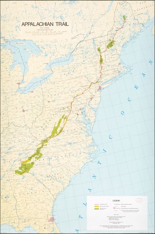
English: "March 1981." Cover title of accompanying text: Comprehensive plan. Spine title of accompanying text: Appalachian Trail comprehensive plan. "Source Data: Map base is Geological Survey 1:2,500,000 scale map, dated 1972." Accompanied by text: Comprehensive plan for the protection, management, development, and use of the Appalachian National Scenic Trail, Sept. 1981 (43, [97] p. : ill., maps (1 folded) ; 28 cm.) Notes, ill., and 3 strip maps of "Appalachian Trail" (scale 1:600,000) on verso. Available also through the Library of Congress Web site as a raster image. |
||
| Title | Appalachian Trail | ||
| Shelf ID | G3709.32.A6 1981 .U52 | ||
| Date | |||
| Source | https://www.loc.gov/item/83694254/ | ||
| Author | United States. National Park Service. Appalachian Trail Project Office; Cartography, Inc | ||
| Permission (Reusing this file) |
|
||
| Other versions |
|
||
| Location | United States · Appalachian Trail | ||
| Part of | American Memory · General Maps · Catalog · Geography And Map Division | ||
| Subject | Planning · Maps · Appalachian Trail · United States |


Licensing
edit| This image or media file contains material based on a work of a National Park Service employee, created as part of that person's official duties. As a work of the U.S. federal government, such work is in the public domain in the United States. See the NPS website and NPS copyright policy for more information. |
File history
Click on a date/time to view the file as it appeared at that time.
| Date/Time | Thumbnail | Dimensions | User | Comment | |
|---|---|---|---|---|---|
| current | 15:54, 24 May 2018 |  | 8,868 × 13,397 (339.9 MB) | Fæ (talk | contribs) | LOC Maps https://www.loc.gov/item/83694254/ #315 |
You cannot overwrite this file.
File usage on Commons
The following page uses this file: